Property Record
3346 N Main St, Spanish Fork, UT 84660
NEARBY LISTINGS FOR SALE OR LEASE
Property Detail
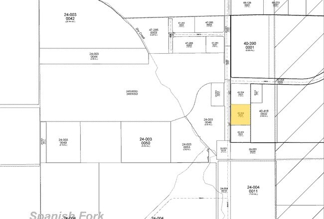
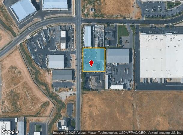
3346 N Main St
Salt Lake City
Gateway Commerce Park Subdv
Provo-Orem, UT
LOT 2, PLAT A, GATEWAY COMMERCE PARK SUBDV. AREA 1.180 AC.
40-304-0002
Utah
Officebuilding
Utah
2024
2
2025
1.18 AC
010503
Utah County
19,587 SF
DEMOGRAPHICS near 3346 N Main St
1 Mile
3 Mile
5 Mile
2024 Total Population
3,628
34,544
109,057
2029 Population
4,208
40,391
127,595
Pop Growth 2024-2029
+ 15.99%
+ 16.93%
+ 17.00%
Average Age
33
31
32
2024 Total Households
1,151
10,289
30,680
HH Growth 2024-2029
+ 16.42%
+ 17.20%
+ 17.31%
Median Household Inc
$67,997
$73,572
$87,759
Avg Household Size
2.90
3.30
3.50
2024 Avg HH Vehicles
2.00
2.00
2.00
Median Home Value
$454,294
$375,607
$429,537
Median Year Built
2006
1998
1998
Nearby Places
Map Layers
Map Styles
 Street
 Aerial
- Restaurants
- Banks
- Shops
- Fitness
- Groceries
PUBLIC TRANSPORTATION
COMMUTER RAIL
Provo Central Station (FrontRunner - Utah Transit Authority (UTA))
DRIVE
WALK
Distance
Provo Central Station (FrontRunner - Utah Transit Authority (UTA))
9 min
6.1 mi
Provo Amtrak (California Zephyr - Amtrak)
DRIVE
WALK
Distance
Provo Amtrak (California Zephyr - Amtrak)
9 min
6.1 mi
AIRPORT
Provo Municipal
DRIVE
WALK
Distance
Provo Municipal
13 min
8.1 mi
Freight Ports
Port of Stockton
DRIVE
WALK
Distance
Port of Stockton
762 min
744.6 mi
Nearby Properties
Address
Land Use
TOTAL SIZE
Lot Size
Zoning
Address
Land Use
TOTAL SIZE
Lot Size
Zoning
44,552 SF
29.78 AC
Address
Land Use
TOTAL SIZE
Lot Size
Zoning
69,236 SF
30.28 AC
Address
Land Use
TOTAL SIZE
Lot Size
Zoning
565,605 SF
20 AC
Address
Land Use
TOTAL SIZE
Lot Size
Zoning
263,859 SF
12.80 AC
Address
Land Use
TOTAL SIZE
Lot Size
Zoning
281,008 SF
16.65 AC
Address
Land Use
TOTAL SIZE
Lot Size
Zoning
370,735 SF
18.54 AC
Address
Land Use
TOTAL SIZE
Lot Size
Zoning
281,008 SF
14.84 AC
Address
Land Use
TOTAL SIZE
Lot Size
Zoning
204,890 SF
15.28 AC
Address
Land Use
TOTAL SIZE
Lot Size
Zoning
271,536 SF
11.80 AC
Address
Land Use
TOTAL SIZE
Lot Size
Zoning
301,852 SF
20.24 AC
Address
Land Use
TOTAL SIZE
Lot Size
Zoning
170,774 SF
9.70 AC
Address
Land Use
TOTAL SIZE
Lot Size
Zoning
243,888 SF
32.23 AC
Address
Land Use
TOTAL SIZE
Lot Size
Zoning
159,679 SF
12.91 AC
Address
Land Use
TOTAL SIZE
Lot Size
Zoning
322,432 SF
29.36 AC
Address
Land Use
TOTAL SIZE
Lot Size
Zoning
210,644 SF
19.55 AC
Address
Land Use
TOTAL SIZE
Lot Size
Zoning
125,729 SF
12.84 AC
Address
Land Use
TOTAL SIZE
Lot Size
Zoning
29,819 SF
13.51 AC
Address
Land Use
TOTAL SIZE
Lot Size
Zoning
240,674 SF
19.41 AC
Address
Land Use
TOTAL SIZE
Lot Size
Zoning
238,651 SF
14.45 AC
Address
Land Use
TOTAL SIZE
Lot Size
Zoning
45,976 SF
39.98 AC
Address
Land Use
TOTAL SIZE
Lot Size
Zoning
184,079 SF
11.47 AC
Address
Land Use
TOTAL SIZE
Lot Size
Zoning
149,046 SF
12.10 AC
Address
Land Use
TOTAL SIZE
Lot Size
Zoning
141,566 SF
7.89 AC
Address
Land Use
TOTAL SIZE
Lot Size
Zoning
231,991 SF
13.76 AC
Address
Land Use
TOTAL SIZE
Lot Size
Zoning
79,260 SF
5.24 AC
Address
Land Use
TOTAL SIZE
Lot Size
Zoning
134,564 SF
8.03 AC
Address
Land Use
TOTAL SIZE
Lot Size
Zoning
70.92 AC
Address
Land Use
TOTAL SIZE
Lot Size
Zoning
124,255 SF
9.87 AC
Address
Land Use
TOTAL SIZE
Lot Size
Zoning
112,094 SF
10.34 AC
Address
Land Use
TOTAL SIZE
Lot Size
Zoning
120,613 SF
5.13 AC
The World's #1 Commercial Real Estate Marketplace
Connect with us
© 2025 CoStar Group
The information above has been obtained from sources believed reliable. While we do not doubt its accuracy we have not verified it and make no guarantee, warranty or representation about it. It is your responsibility to independently confirm its accuracy and completeness. Any projections, opinions, assumptions, or estimates used are for example only and do not represent the current or future performance of the property. The value of this transaction to you depends on tax and other factors which should be evaluated by your tax, financial, and legal advisors. You and your advisors should conduct a careful, independent investigation of the property to determine to your satisfaction the suitability of the property for your needs.