Property Record
3347 N Clark St, Chicago, IL 60657
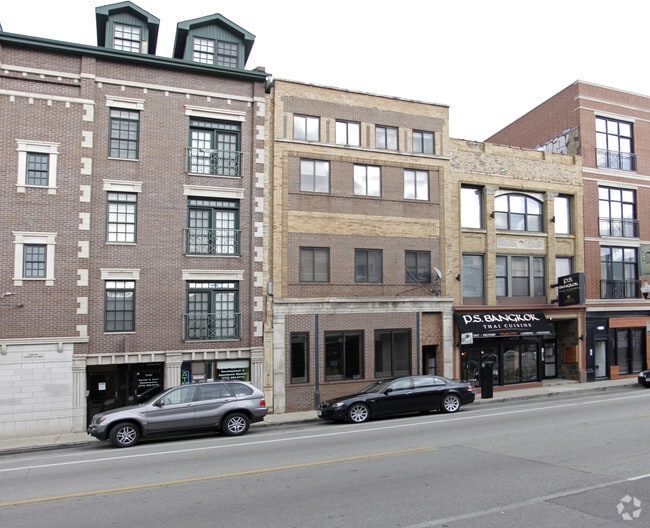
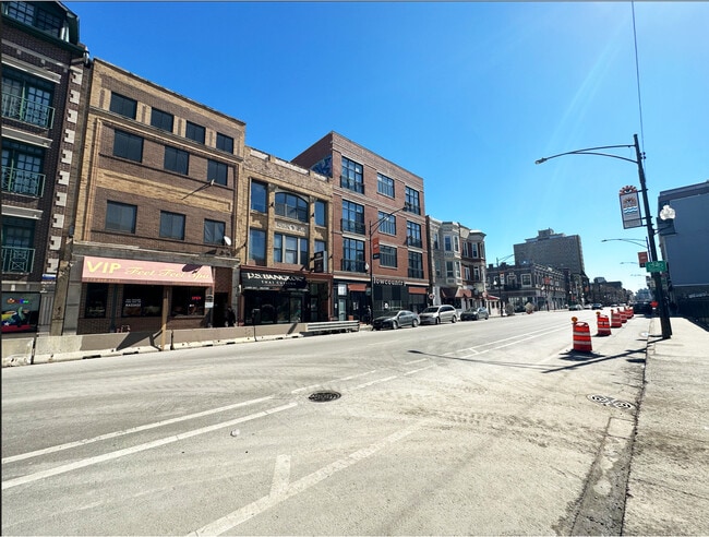
This Property Is For Sale
NEARBY LISTINGS FOR SALE OR LEASE
Property Detail
3347 N Clark St
Chicago-Naperville-Elgin, IL-IN-WI
3347 Clark St Lofts Condo
14-20-419-102-1004
Cook
Condominium
Illinois
X
0.07 AC
17031C0409K
Lincoln Park
1,100 SF
Chicago
DEMOGRAPHICS near 3347 N Clark St
1 Mile
3 Mile
5 Mile
2024 Total Population
105,131
438,488
1,016,706
2029 Population
102,371
425,528
983,546
Pop Growth 2024-2029
(2.63%)
(2.96%)
(3.26%)
Average Age
35
37
37
2024 Total Households
59,282
227,379
493,914
HH Growth 2024-2029
(2.85%)
(3.11%)
(3.17%)
Median Household Inc
$94,954
$97,278
$90,953
Avg Household Size
1.70
1.90
2.00
2024 Avg HH Vehicles
1.00
1.00
1.00
Median Home Value
$471,500
$507,710
$453,534
Median Year Built
1961
1958
1959
Nearby Places
- Restaurants
- Banks
- Shops
- Fitness
- Groceries
PUBLIC TRANSPORTATION
TRANSIT/SUBWAY
Addison Station (Red Line) (Red Line - Chicago Transit Authority "L" Trains (The "L"))
DRIVE
WALK
Distance
Addison Station (Red Line) (Red Line - Chicago Transit Authority "L" Trains (The "L"))
1 min
6 min
0.4 mi
Belmont Station (Brown, Purple, Red Lines) (Brown Line - Chicago Transit Authority "L" Trains (The "L"), Purple Line - Chicago Transit Authority "L" Trains (The "L"), Red Line - Chicago Transit Authority "L" Trains (The "L"))
DRIVE
WALK
Distance
Belmont Station (Brown, Purple, Red Lines) (Brown Line - Chicago Transit Authority "L" Trains (The "L"), Purple Line - Chicago Transit Authority "L" Trains (The "L"), Red Line - Chicago Transit Authority "L" Trains (The "L"))
1 min
7 min
0.4 mi
Southport Station (Brown Line - Chicago Transit Authority "L" Trains (The "L"))
DRIVE
WALK
Distance
Southport Station (Brown Line - Chicago Transit Authority "L" Trains (The "L"))
2 min
11 min
0.6 mi
Wellington Station (Brown Line - Chicago Transit Authority "L" Trains (The "L"), Purple Line - Chicago Transit Authority "L" Trains (The "L"))
DRIVE
WALK
Distance
Wellington Station (Brown Line - Chicago Transit Authority "L" Trains (The "L"), Purple Line - Chicago Transit Authority "L" Trains (The "L"))
2 min
11 min
0.6 mi
Diversey Station (Brown Line - Chicago Transit Authority "L" Trains (The "L"), Purple Line - Chicago Transit Authority "L" Trains (The "L"))
DRIVE
WALK
Distance
Diversey Station (Brown Line - Chicago Transit Authority "L" Trains (The "L"), Purple Line - Chicago Transit Authority "L" Trains (The "L"))
2 min
16 min
0.9 mi
COMMUTER RAIL
Ravenswood Station (Union Pacific North Line - Northeast Illinois Regional Commuter Railroad (Metra))
DRIVE
WALK
Distance
Ravenswood Station (Union Pacific North Line - Northeast Illinois Regional Commuter Railroad (Metra))
5 min
2.3 mi
Clybourn Station (Union Pacific North Line - Northeast Illinois Regional Commuter Railroad (Metra), Union Pacific Northwest Line - Northeast Illinois Regional Commuter Railroad (Metra))
DRIVE
WALK
Distance
Clybourn Station (Union Pacific North Line - Northeast Illinois Regional Commuter Railroad (Metra), Union Pacific Northwest Line - Northeast Illinois Regional Commuter Railroad (Metra))
6 min
2.9 mi
AIRPORT
Chicago O'Hare International
DRIVE
WALK
Distance
Chicago O'Hare International
24 min
14.5 mi
Chicago Midway International
DRIVE
WALK
Distance
Chicago Midway International
26 min
14.7 mi
Freight Ports
Port Milwaukee
DRIVE
WALK
Distance
Port Milwaukee
102 min
82.8 mi
Nearby Properties
Address
Land Use
TOTAL SIZE
Lot Size
Zoning
Address
Land Use
TOTAL SIZE
Lot Size
Zoning
1.09 AC
B1-3
Address
Land Use
TOTAL SIZE
Lot Size
Zoning
228,018 SF
8.72 AC
PD 958
Address
Land Use
TOTAL SIZE
Lot Size
Zoning
222,240 SF
2.45 AC
PD 1439
Address
Land Use
TOTAL SIZE
Lot Size
Zoning
266,248 SF
Address
Land Use
TOTAL SIZE
Lot Size
Zoning
602,197 SF
Address
Land Use
TOTAL SIZE
Lot Size
Zoning
623,912 SF
Address
Land Use
TOTAL SIZE
Lot Size
Zoning
61,300 SF
0.30 AC
B3-5
Address
Land Use
TOTAL SIZE
Lot Size
Zoning
652,620 SF
Address
Land Use
TOTAL SIZE
Lot Size
Zoning
1,426,524 SF
2.15 AC
RM-6.5
Address
Land Use
TOTAL SIZE
Lot Size
Zoning
0.96 AC
PD 958
Address
Land Use
TOTAL SIZE
Lot Size
Zoning
24,296 SF
0.25 AC
RM-5
Address
Land Use
TOTAL SIZE
Lot Size
Zoning
16.93 AC
POS-1,PD 1
Address
Land Use
TOTAL SIZE
Lot Size
Zoning
19,500 SF
12.06 AC
PD 367
Address
Land Use
TOTAL SIZE
Lot Size
Zoning
0.21 AC
B1-3
Address
Land Use
TOTAL SIZE
Lot Size
Zoning
376,302 SF
PD 1019
Address
Land Use
TOTAL SIZE
Lot Size
Zoning
434,320 SF
1.16 AC
C3-5
Address
Land Use
TOTAL SIZE
Lot Size
Zoning
268,778 SF
0.59 AC
RM-6.5
Address
Land Use
TOTAL SIZE
Lot Size
Zoning
301,100 SF
2.20 AC
PD 37
Address
Land Use
TOTAL SIZE
Lot Size
Zoning
1 AC
RS-3
Address
Land Use
TOTAL SIZE
Lot Size
Zoning
1.06 AC
PD 157
Address
Land Use
TOTAL SIZE
Lot Size
Zoning
0.64 AC
PD 158
Address
Land Use
TOTAL SIZE
Lot Size
Zoning
0.81 AC
PD 158
Address
Land Use
TOTAL SIZE
Lot Size
Zoning
1.32 AC
PD 1398
Address
Land Use
TOTAL SIZE
Lot Size
Zoning
82,000 SF
9.68 AC
PD 437
Address
Land Use
TOTAL SIZE
Lot Size
Zoning
277,195 SF
1.78 AC
PD 1094
Address
Land Use
TOTAL SIZE
Lot Size
Zoning
255,926 SF
0.73 AC
RM-6.5
Address
Land Use
TOTAL SIZE
Lot Size
Zoning
190,011 SF
5.90 AC
PD 353
Address
Land Use
TOTAL SIZE
Lot Size
Zoning
1,184,800 SF
3.74 AC
PMD 2,PD 1
Address
Land Use
TOTAL SIZE
Lot Size
Zoning
16,600 SF
3.67 AC
PMD 2,PD 1
Address
Land Use
TOTAL SIZE
Lot Size
Zoning
147,835 SF
1.03 AC
PD 37
The World's #1 Commercial Real Estate Marketplace
Connect with us
© 2025 CoStar Group
The information above has been obtained from sources believed reliable. While we do not doubt its accuracy we have not verified it and make no guarantee, warranty or representation about it. It is your responsibility to independently confirm its accuracy and completeness. Any projections, opinions, assumptions, or estimates used are for example only and do not represent the current or future performance of the property. The value of this transaction to you depends on tax and other factors which should be evaluated by your tax, financial, and legal advisors. You and your advisors should conduct a careful, independent investigation of the property to determine to your satisfaction the suitability of the property for your needs.