Property Record
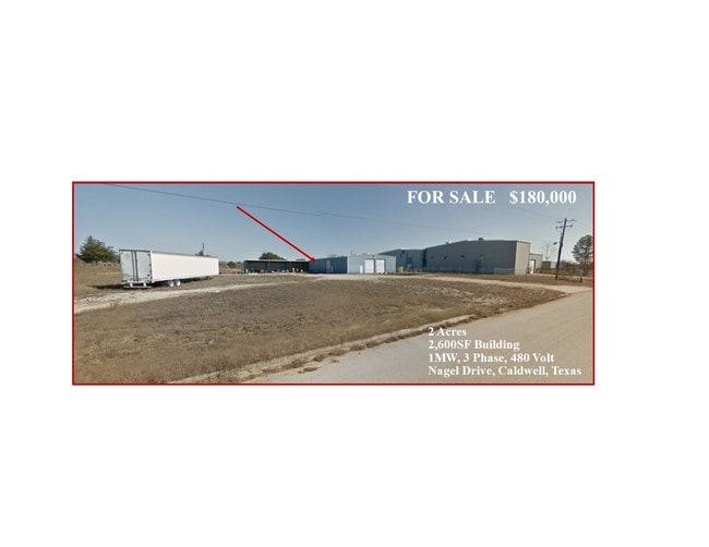
229 Nagel Dr, Caldwell, TX 77836

Property Detail
229 Nagel Dr
16411
S1522 NAGEL INDUSTRIAL PARK 5.109 ACRES
Industrialgeneral
Burleson
B and X Area of moderate flood hazard, usually the area between the limits of the 100-year and 500-year floods.
Texas
2025
5.11 AC
2025
Bryan & College Station
970300
Other Market Areas
39,860 SF
College Station-Bryan, TX
NEARBY LISTINGS FOR SALE OR LEASE
DEMOGRAPHICS near 229 Nagel Dr
1 mile
3 mile
5 mile
2025 Total Population
3,095
5,451
6,823
2030 Population
3,514
6,195
7,759
Pop Growth 2025-2030
+ 13.54%
+ 13.65%
+ 13.72%
Average Age
39
41
42
2025 Total Households
1,208
2,150
2,699
HH Growth 2025-2030
+ 13.99%
+ 14.23%
+ 14.30%
Median Household Inc
$59,374
$76,949
$78,650
Avg Household Size
2.50
2.50
2.50
2025 Avg HH Vehicles
2.00
2.00
2.00
Median Home Value
$196,218
$233,385
$242,801
Median Year Built
1987
1988
1989
Nearby Places
Map Layers
Map Styles
 Street
 Aerial
Layers
 Traffic
 Biking
Places
Listings with unknown addresses are not visible on the map
- Restaurants
- Banks
- Shops
- Fitness
- Groceries
PUBLIC TRANSPORTATION
AIRPORT
Easterwood Field
Drive
Walk
Distance
Easterwood Field
41 min
29.1 mi
Freight Ports
Port of Houston
Drive
Walk
Distance
Port of Houston
153 min
116.9 mi
SALE & LEASE HISTORY
LISTING DATE
SALE/LEASE

Feb 03, 2019
For Sale
Nearby Properties
Address
Land Use
TOTAL SIZE
Lot Size
Zoning
Address
Land Use
TOTAL SIZE
Lot Size
Zoning
50,000 SF
23.49 AC
Address
Land Use
TOTAL SIZE
Lot Size
Zoning
95,892 SF
10.45 AC
Address
Land Use
TOTAL SIZE
Lot Size
Zoning
20,648 SF
1 AC
Address
Land Use
TOTAL SIZE
Lot Size
Zoning
16,611 SF
0.52 AC
Address
Land Use
TOTAL SIZE
Lot Size
Zoning
53,134 SF
5.83 AC
Address
Land Use
TOTAL SIZE
Lot Size
Zoning
4,000 SF
18.08 AC
Address
Land Use
TOTAL SIZE
Lot Size
Zoning
12,424 SF
10.45 AC
Address
Land Use
TOTAL SIZE
Lot Size
Zoning
11,178 SF
1.58 AC
Address
Land Use
TOTAL SIZE
Lot Size
Zoning
11,196 SF
0.24 AC
Address
Land Use
TOTAL SIZE
Lot Size
Zoning
13,779 SF
3.65 AC
Address
Land Use
TOTAL SIZE
Lot Size
Zoning
14,400 SF
5.04 AC
Address
Land Use
TOTAL SIZE
Lot Size
Zoning
9,822 SF
65.14 AC
Address
Land Use
TOTAL SIZE
Lot Size
Zoning
774.81 AC
Address
Land Use
TOTAL SIZE
Lot Size
Zoning
32,046 SF
1.55 AC
Address
Land Use
TOTAL SIZE
Lot Size
Zoning
952 SF
331.36 AC
Address
Land Use
TOTAL SIZE
Lot Size
Zoning
26,430 SF
1.58 AC
Address
Land Use
TOTAL SIZE
Lot Size
Zoning
25,032 SF
2.07 AC
Address
Land Use
TOTAL SIZE
Lot Size
Zoning
14,584 SF
29.33 AC
Address
Land Use
TOTAL SIZE
Lot Size
Zoning
5,890 SF
2 AC
Address
Land Use
TOTAL SIZE
Lot Size
Zoning
390.85 AC
Address
Land Use
TOTAL SIZE
Lot Size
Zoning
16,728 SF
371.85 AC
Address
Land Use
TOTAL SIZE
Lot Size
Zoning
2,955 SF
359.44 AC
Address
Land Use
TOTAL SIZE
Lot Size
Zoning
1,140 SF
290 AC
Address
Land Use
TOTAL SIZE
Lot Size
Zoning
12,546 SF
0.65 AC
Address
Land Use
TOTAL SIZE
Lot Size
Zoning
17,567 SF
0.83 AC
Address
Land Use
TOTAL SIZE
Lot Size
Zoning
22,301 SF
4.17 AC
Address
Land Use
TOTAL SIZE
Lot Size
Zoning
29,200 SF
4.03 AC
Address
Land Use
TOTAL SIZE
Lot Size
Zoning
71,505 SF
90.99 AC
Address
Land Use
TOTAL SIZE
Lot Size
Zoning
57.19 AC
Address
Land Use
TOTAL SIZE
Lot Size
Zoning
18,090 SF
9.38 AC
The World's #1 Commercial Real Estate Marketplace
Connect with us
© 2026 CoStar Group
The information above has been obtained from sources believed reliable. While we do not doubt its accuracy we have not verified it and make no guarantee, warranty or representation about it. It is your responsibility to independently confirm its accuracy and completeness. Any projections, opinions, assumptions, or estimates used are for example only and do not represent the current or future performance of the property. The value of this transaction to you depends on tax and other factors which should be evaluated by your tax, financial, and legal advisors. You and your advisors should conduct a careful, independent investigation of the property to determine to your satisfaction the suitability of the property for your needs.