Property Record
335 Oxford St, Dover, OH 44622


Property Detail
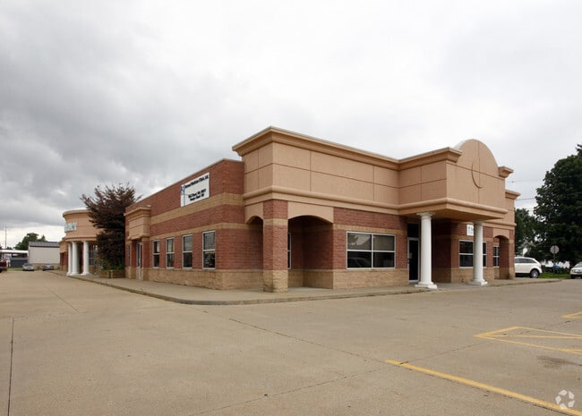
335 Oxford St
1500812000
2 9 3-2 94 1.415A
Medicalbuilding
Tuscarawas
C and X Area of minimal flood hazard, usually depicted on FIRMs as above the 500-year flood level.
Ohio
2025
1.42 AC
2025
Ohio North Area
021100
Other Market Areas
14,378 SF
New Philadelphia-Dover, OH
NEARBY LISTINGS FOR SALE OR LEASE
-
-
View all Dover listings for sale on LoopNet.com
DEMOGRAPHICS near 335 Oxford St
1 mile
3 mile
5 mile
2025 Total Population
6,899
29,407
38,967
2030 Population
6,866
29,479
38,943
Pop Growth 2025-2030
(0.48%)
+ 0.24%
(0.06%)
Average Age
40
42
42
2025 Total Households
2,779
12,181
16,226
HH Growth 2025-2030
(0.47%)
+ 0.20%
(0.10%)
Median Household Inc
$54,633
$58,568
$61,319
Avg Household Size
2.30
2.30
2.30
2025 Avg HH Vehicles
2.00
2.00
2.00
Median Home Value
$160,237
$184,279
$194,745
Median Year Built
1952
1960
1966
Nearby Places
Map Layers
Map Styles
 Street
 Aerial
Layers
 Traffic
 Biking
Places
Listings with unknown addresses are not visible on the map
- Restaurants
- Banks
- Shops
- Fitness
- Groceries
PUBLIC TRANSPORTATION
AIRPORT
Akron-Canton Regional
Drive
Walk
Distance
Akron-Canton Regional
40 min
33.3 mi
SALE & LEASE HISTORY
LISTING DATE
SALE/LEASE

Mar 26, 2024
For Sale
Nearby Properties
Address
Land Use
TOTAL SIZE
Lot Size
Zoning
Address
Land Use
TOTAL SIZE
Lot Size
Zoning
100,419 SF
3.59 AC
Address
Land Use
TOTAL SIZE
Lot Size
Zoning
132,702 SF
8.56 AC
Address
Land Use
TOTAL SIZE
Lot Size
Zoning
6.57 AC
Address
Land Use
TOTAL SIZE
Lot Size
Zoning
184,849 SF
28.36 AC
Address
Land Use
TOTAL SIZE
Lot Size
Zoning
173,870 SF
41.49 AC
Address
Land Use
TOTAL SIZE
Lot Size
Zoning
432,396 SF
39.33 AC
Address
Land Use
TOTAL SIZE
Lot Size
Zoning
196,289 SF
22.57 AC
Address
Land Use
TOTAL SIZE
Lot Size
Zoning
143,819 SF
6.57 AC
Address
Land Use
TOTAL SIZE
Lot Size
Zoning
38,869 SF
2.98 AC
Address
Land Use
TOTAL SIZE
Lot Size
Zoning
4,021,013 SF
12 AC
Address
Land Use
TOTAL SIZE
Lot Size
Zoning
15,620 SF
3.04 AC
Address
Land Use
TOTAL SIZE
Lot Size
Zoning
22,049 SF
2.70 AC
Address
Land Use
TOTAL SIZE
Lot Size
Zoning
47,650 SF
1.60 AC
Address
Land Use
TOTAL SIZE
Lot Size
Zoning
56,820 SF
8 AC
Address
Land Use
TOTAL SIZE
Lot Size
Zoning
36,350 SF
3.04 AC
Address
Land Use
TOTAL SIZE
Lot Size
Zoning
19,808 SF
0.80 AC
Address
Land Use
TOTAL SIZE
Lot Size
Zoning
70,357 SF
1.61 AC
Address
Land Use
TOTAL SIZE
Lot Size
Zoning
4,513,504 SF
2.04 AC
Address
Land Use
TOTAL SIZE
Lot Size
Zoning
68,337 SF
6.31 AC
Address
Land Use
TOTAL SIZE
Lot Size
Zoning
10.01 AC
Address
Land Use
TOTAL SIZE
Lot Size
Zoning
87,559 SF
11.85 AC
Address
Land Use
TOTAL SIZE
Lot Size
Zoning
80,960 SF
10.34 AC
Address
Land Use
TOTAL SIZE
Lot Size
Zoning
2 SF
12.34 AC
Address
Land Use
TOTAL SIZE
Lot Size
Zoning
86,410 SF
10.85 AC
Address
Land Use
TOTAL SIZE
Lot Size
Zoning
89,184 SF
7.21 AC
Address
Land Use
TOTAL SIZE
Lot Size
Zoning
12,425 SF
2.53 AC
Address
Land Use
TOTAL SIZE
Lot Size
Zoning
85,257 SF
12.28 AC
Address
Land Use
TOTAL SIZE
Lot Size
Zoning
46,624 SF
8.32 AC
Address
Land Use
TOTAL SIZE
Lot Size
Zoning
42,760 SF
7.11 AC
Address
Land Use
TOTAL SIZE
Lot Size
Zoning
14,078 SF
2.30 AC
The World's #1 Commercial Real Estate Marketplace
Connect with us
© 2026 CoStar Group
The information above has been obtained from sources believed reliable. While we do not doubt its accuracy we have not verified it and make no guarantee, warranty or representation about it. It is your responsibility to independently confirm its accuracy and completeness. Any projections, opinions, assumptions, or estimates used are for example only and do not represent the current or future performance of the property. The value of this transaction to you depends on tax and other factors which should be evaluated by your tax, financial, and legal advisors. You and your advisors should conduct a careful, independent investigation of the property to determine to your satisfaction the suitability of the property for your needs.