Property Record
335 Route 202, Chalfont, PA 18914


Save to a Folder
{{folder.Name}}
{{folder.ListingIds.length}} Properties
{{folder.ListingIds.length}} Property
Create a New Folder
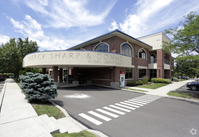
Property Detail
335 Route 202
26-005-033
3.585A NW COR US202 & T33 4
Officebuilding
BUCKS
C1
Pennsylvania
B and X Area of moderate flood hazard, usually the area between the limits of the 100-year and 500-year floods.
3.59 AC
2025
Upper Bucks County
2026
Philadelphia
101900
Philadelphia-Camden-Wilmington, PA-NJ-DE-MD
27,178 SF
NEARBY LISTINGS FOR SALE OR LEASE
DEMOGRAPHICS near 335 Route 202
1 mile
3 mile
5 mile
2025 Total Population
7,905
49,404
139,041
2030 Population
7,954
50,172
142,392
Pop Growth 2025-2030
+ 0.62%
+ 1.55%
+ 2.41%
Average Age
43
43
43
2025 Total Households
3,070
18,023
51,218
HH Growth 2025-2030
+ 0.68%
+ 1.63%
+ 2.32%
Median Household Inc
$117,054
$127,353
$113,088
Avg Household Size
2.50
2.70
2.60
2025 Avg HH Vehicles
2.00
2.00
2.00
Median Home Value
$441,435
$482,345
$481,431
Median Year Built
1982
1985
1983
Nearby Places
Map Layers
Map Styles
 Street
 Aerial
Layers
 Traffic
 Biking
Places
Listings with unknown addresses are not visible on the map
- Restaurants
- Banks
- Shops
- Fitness
- Groceries
PUBLIC TRANSPORTATION
COMMUTER RAIL
Chalfont (R5 - Southeastern Pennsylvania Transportation Authority Regional Rail (SEPTA Regional Rail))
Drive
Walk
Distance
Chalfont (R5 - Southeastern Pennsylvania Transportation Authority Regional Rail (SEPTA Regional Rail))
4 min
1.4 mi
Link Belt (R5 - Southeastern Pennsylvania Transportation Authority Regional Rail (SEPTA Regional Rail))
Drive
Walk
Distance
Link Belt (R5 - Southeastern Pennsylvania Transportation Authority Regional Rail (SEPTA Regional Rail))
4 min
2.0 mi
AIRPORT
Trenton Mercer
Drive
Walk
Distance
Trenton Mercer
49 min
28.7 mi
Lehigh Valley International
Drive
Walk
Distance
Lehigh Valley International
57 min
34.9 mi
Philadelphia International
Drive
Walk
Distance
Philadelphia International
62 min
36.6 mi
Freight Ports
Port of Philadelphia
Drive
Walk
Distance
Port of Philadelphia
41 min
25.1 mi
Nearby Properties
Address
Land Use
TOTAL SIZE
Lot Size
Zoning
Address
Land Use
TOTAL SIZE
Lot Size
Zoning
301,431 SF
41.90 AC
S
Address
Land Use
TOTAL SIZE
Lot Size
Zoning
517,834 SF
31.33 AC
GA
Address
Land Use
TOTAL SIZE
Lot Size
Zoning
245,104 SF
31.21 AC
C
Address
Land Use
TOTAL SIZE
Lot Size
Zoning
334,450 SF
18.86 AC
GA
Address
Land Use
TOTAL SIZE
Lot Size
Zoning
142,336 SF
3.17 AC
RS
Address
Land Use
TOTAL SIZE
Lot Size
Zoning
89,349 SF
18.11 AC
R1
Address
Land Use
TOTAL SIZE
Lot Size
Zoning
87,819 SF
1.82 AC
S
Address
Land Use
TOTAL SIZE
Lot Size
Zoning
119,740 SF
9.80 AC
BP
Address
Land Use
TOTAL SIZE
Lot Size
Zoning
136,473 SF
9.44 AC
LI
Address
Land Use
TOTAL SIZE
Lot Size
Zoning
88,060 SF
20.74 AC
R1
Address
Land Use
TOTAL SIZE
Lot Size
Zoning
77,805 SF
21.18 AC
R2
Address
Land Use
TOTAL SIZE
Lot Size
Zoning
148,670 SF
4.63 AC
C
Address
Land Use
TOTAL SIZE
Lot Size
Zoning
134,272 SF
3.11 AC
S
Address
Land Use
TOTAL SIZE
Lot Size
Zoning
38,713 SF
12.89 AC
LI
Address
Land Use
TOTAL SIZE
Lot Size
Zoning
164,376 SF
12.87 AC
LI
Address
Land Use
TOTAL SIZE
Lot Size
Zoning
380,875 SF
40.10 AC
LI
Address
Land Use
TOTAL SIZE
Lot Size
Zoning
63,646 SF
6.05 AC
RSA
Address
Land Use
TOTAL SIZE
Lot Size
Zoning
36,451 SF
22.94 AC
R2
Address
Land Use
TOTAL SIZE
Lot Size
Zoning
82,592 SF
11.50 AC
LI
Address
Land Use
TOTAL SIZE
Lot Size
Zoning
45,457 SF
6.32 AC
C
Address
Land Use
TOTAL SIZE
Lot Size
Zoning
56,522 SF
5.01 AC
C
Address
Land Use
TOTAL SIZE
Lot Size
Zoning
361,858 SF
27.82 AC
LI
Address
Land Use
TOTAL SIZE
Lot Size
Zoning
68,854 SF
7.24 AC
C
Address
Land Use
TOTAL SIZE
Lot Size
Zoning
86,930 SF
1.76 AC
LI
Address
Land Use
TOTAL SIZE
Lot Size
Zoning
42,528 SF
4.43 AC
LI
Address
Land Use
TOTAL SIZE
Lot Size
Zoning
37,637 SF
4.60 AC
C
Address
Land Use
TOTAL SIZE
Lot Size
Zoning
5,856 SF
2.37 AC
LI
Address
Land Use
TOTAL SIZE
Lot Size
Zoning
134,704 SF
34.23 AC
PC1
Address
Land Use
TOTAL SIZE
Lot Size
Zoning
6,152 SF
122.14 AC
R1
Address
Land Use
TOTAL SIZE
Lot Size
Zoning
42,494 SF
11.19 AC
C
The World's #1 Commercial Real Estate Marketplace
Connect with us
© 2026 CoStar Group
The information above has been obtained from sources believed reliable. While we do not doubt its accuracy we have not verified it and make no guarantee, warranty or representation about it. It is your responsibility to independently confirm its accuracy and completeness. Any projections, opinions, assumptions, or estimates used are for example only and do not represent the current or future performance of the property. The value of this transaction to you depends on tax and other factors which should be evaluated by your tax, financial, and legal advisors. You and your advisors should conduct a careful, independent investigation of the property to determine to your satisfaction the suitability of the property for your needs.