Property Record
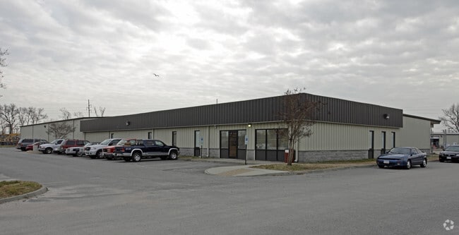
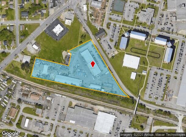
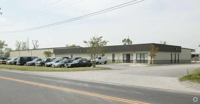
3350 Elm Ave, Portsmouth, VA 23704
NEARBY LISTINGS FOR SALE OR LEASE
Property Detail
3350 Elm Ave
0399-0140
Commercial District 3
Taxexempt
PAR Z MIN SUB OF 3209 GEO WASH HWY
AE
Portsmouth
5101040058H
Virginia
2024
7.03 AC
2025
Portsmouth
212300
Hampton Roads
36,646 SF
Virginia Beach-Norfolk-Newport News, VA-NC
DEMOGRAPHICS near 3350 Elm Ave
1 Mile
3 Mile
5 Mile
2024 Total Population
12,654
88,949
231,382
2029 Population
12,729
89,730
233,306
Pop Growth 2024-2029
+ 0.59%
+ 0.88%
+ 0.83%
Average Age
34
37
37
2024 Total Households
4,403
36,020
92,283
HH Growth 2024-2029
+ 0.57%
+ 0.65%
+ 0.64%
Median Household Inc
$38,759
$51,083
$55,939
Avg Household Size
2.70
2.40
2.40
2024 Avg HH Vehicles
1.00
2.00
2.00
Median Home Value
$158,784
$187,009
$221,085
Median Year Built
1957
1963
1971
Nearby Places
Map Layers
Map Styles
 Street
 Aerial
- Restaurants
- Banks
- Shops
- Fitness
- Groceries
PUBLIC TRANSPORTATION
COMMUTER RAIL
DRIVE
WALK
Distance
8 min
3.8 mi
AIRPORT
Norfolk International
DRIVE
WALK
Distance
Norfolk International
21 min
10.2 mi
Newport News/Williamsburg International
DRIVE
WALK
Distance
Newport News/Williamsburg International
48 min
33.6 mi
Freight Ports
Virginia Port Authority - Portsmouth
DRIVE
WALK
Distance
Virginia Port Authority - Portsmouth
11 min
4.4 mi
Nearby Properties
Address
Land Use
TOTAL SIZE
Lot Size
Zoning
Address
Land Use
TOTAL SIZE
Lot Size
Zoning
5,704 SF
4.67 AC
D2
Address
Land Use
TOTAL SIZE
Lot Size
Zoning
250,000 SF
38 AC
MUH
Address
Land Use
TOTAL SIZE
Lot Size
Zoning
300,829 SF
38.40 AC
IL
Address
Land Use
TOTAL SIZE
Lot Size
Zoning
482.38 AC
MULTI: MUL
Address
Land Use
TOTAL SIZE
Lot Size
Zoning
250,766 SF
31.14 AC
NMU
Address
Land Use
TOTAL SIZE
Lot Size
Zoning
421,856 SF
2.64 AC
D1
Address
Land Use
TOTAL SIZE
Lot Size
Zoning
971,654 SF
6.01 AC
D2
Address
Land Use
TOTAL SIZE
Lot Size
Zoning
473,072 SF
9.72 AC
SD
Address
Land Use
TOTAL SIZE
Lot Size
Zoning
258,000 SF
1.38 AC
M2: GENERA
Address
Land Use
TOTAL SIZE
Lot Size
Zoning
192,270 SF
1.99 AC
D2
Address
Land Use
TOTAL SIZE
Lot Size
Zoning
363,974 SF
1.49 AC
Address
Land Use
TOTAL SIZE
Lot Size
Zoning
66,718 SF
4.09 AC
D5
Address
Land Use
TOTAL SIZE
Lot Size
Zoning
356,598 SF
1.84 AC
D2
Address
Land Use
TOTAL SIZE
Lot Size
Zoning
50,384 SF
0.74 AC
Address
Land Use
TOTAL SIZE
Lot Size
Zoning
252,524 SF
20 AC
R8S: RESID
Address
Land Use
TOTAL SIZE
Lot Size
Zoning
406,344 SF
8.45 AC
GMU
Address
Land Use
TOTAL SIZE
Lot Size
Zoning
35,091 SF
0.71 AC
Address
Land Use
TOTAL SIZE
Lot Size
Zoning
197,074 SF
6.69 AC
Address
Land Use
TOTAL SIZE
Lot Size
Zoning
640,920 SF
3.67 AC
HCEF
Address
Land Use
TOTAL SIZE
Lot Size
Zoning
608,074 SF
0.60 AC
Address
Land Use
TOTAL SIZE
Lot Size
Zoning
254,194 SF
1.93 AC
D3
Address
Land Use
TOTAL SIZE
Lot Size
Zoning
56,217 SF
1.31 AC
Address
Land Use
TOTAL SIZE
Lot Size
Zoning
251,984 SF
0.40 AC
D2
Address
Land Use
TOTAL SIZE
Lot Size
Zoning
128,596 SF
16.91 AC
M2: GENERA
Address
Land Use
TOTAL SIZE
Lot Size
Zoning
5 AC
D1
Address
Land Use
TOTAL SIZE
Lot Size
Zoning
563,325 SF
0.72 AC
D2
Address
Land Use
TOTAL SIZE
Lot Size
Zoning
186,138 SF
0.26 AC
Address
Land Use
TOTAL SIZE
Lot Size
Zoning
20.11 AC
Address
Land Use
TOTAL SIZE
Lot Size
Zoning
237,629 SF
2.65 AC
T6
Address
Land Use
TOTAL SIZE
Lot Size
Zoning
19.66 AC
The World's #1 Commercial Real Estate Marketplace
Connect with us
© 2025 CoStar Group
The information above has been obtained from sources believed reliable. While we do not doubt its accuracy we have not verified it and make no guarantee, warranty or representation about it. It is your responsibility to independently confirm its accuracy and completeness. Any projections, opinions, assumptions, or estimates used are for example only and do not represent the current or future performance of the property. The value of this transaction to you depends on tax and other factors which should be evaluated by your tax, financial, and legal advisors. You and your advisors should conduct a careful, independent investigation of the property to determine to your satisfaction the suitability of the property for your needs.