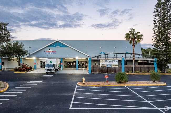
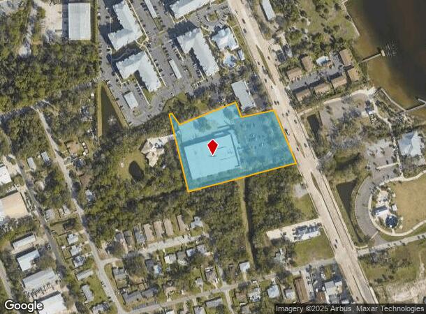
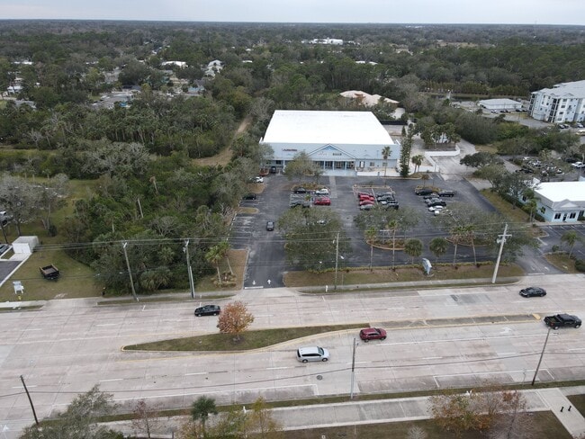
Property Record
3350 S Ridgewood Ave, Port Orange, FL 32129

NEARBY LISTINGS FOR SALE OR LEASE
Property Detail
3350 S Ridgewood Ave
Deltona-Daytona Beach-Ormond Beach, FL
Parcel
6303-00-00-0010
03 16 33 LOT 1 W OF RIDGEWOOD AVE & N OF CANAL EXC IRREG PARCEL BEING N 409.1 FT AS MEAS ON THE W/L & BEING 867.3 FT MEAS ON THE S/L & EXC IRREG PARCEL BEING 466.19 FT ON N/L & MEAS 200 FT ON THE W/L OF US HWY 1 & EXC THE W 1/2 OF THIS PARCEL MEAS 31
Storemultistory
Volusia
AE
Florida
12127C0388J
1
2025
3.61 AC
2025
South Daytona Beach
082511
Deltona/Daytona Beach
41,060 SF
DEMOGRAPHICS near 3350 S Ridgewood Ave
1 Mile
3 Mile
5 Mile
2024 Total Population
6,473
62,542
118,676
2029 Population
7,201
69,989
132,097
Pop Growth 2024-2029
+ 11.25%
+ 11.91%
+ 11.31%
Average Age
43
48
46
2024 Total Households
2,886
30,051
53,872
HH Growth 2024-2029
+ 11.37%
+ 12.26%
+ 11.83%
Median Household Inc
$42,500
$48,502
$52,018
Avg Household Size
2.20
2.00
2.10
2024 Avg HH Vehicles
2.00
2.00
2.00
Median Home Value
$182,926
$207,892
$233,960
Median Year Built
1979
1981
1982
Nearby Places
Map Layers
Map Styles
 Street
 Aerial
- Restaurants
- Banks
- Shops
- Fitness
- Groceries
PUBLIC TRANSPORTATION
AIRPORT
Daytona Beach International
DRIVE
WALK
Distance
Daytona Beach International
15 min
7.2 mi
Orlando Sanford International
DRIVE
WALK
Distance
Orlando Sanford International
58 min
39.7 mi
SALE & LEASE HISTORY
LISTING DATE
SALE/LEASE

Mar 24, 2017
For Lease
Mar 24, 2017
For Sale
Jan 20, 2025
For Lease
Apr 26, 2021
For Sale
Nearby Properties
Address
Land Use
TOTAL SIZE
Lot Size
Zoning
Address
Land Use
TOTAL SIZE
Lot Size
Zoning
490,775 SF
34.26 AC
01MH1
Address
Land Use
TOTAL SIZE
Lot Size
Zoning
396,385 SF
10 AC
01A2
Address
Land Use
TOTAL SIZE
Lot Size
Zoning
13,965 SF
0.70 AC
MH1
Address
Land Use
TOTAL SIZE
Lot Size
Zoning
330,883 SF
19.59 AC
Address
Land Use
TOTAL SIZE
Lot Size
Zoning
325,744 SF
12.23 AC
Address
Land Use
TOTAL SIZE
Lot Size
Zoning
269,133 SF
6.33 AC
Address
Land Use
TOTAL SIZE
Lot Size
Zoning
300,516 SF
70 AC
A2
Address
Land Use
TOTAL SIZE
Lot Size
Zoning
379,591 SF
21.62 AC
MH1
Address
Land Use
TOTAL SIZE
Lot Size
Zoning
306,467 SF
20.76 AC
Address
Land Use
TOTAL SIZE
Lot Size
Zoning
10,360 SF
1.56 AC
Address
Land Use
TOTAL SIZE
Lot Size
Zoning
5,774 SF
0.94 AC
B4
Address
Land Use
TOTAL SIZE
Lot Size
Zoning
150,197 SF
16.07 AC
Address
Land Use
TOTAL SIZE
Lot Size
Zoning
94,338 SF
7.39 AC
Address
Land Use
TOTAL SIZE
Lot Size
Zoning
184,242 SF
14.43 AC
Address
Land Use
TOTAL SIZE
Lot Size
Zoning
9,952 SF
9.30 AC
16RMH
Address
Land Use
TOTAL SIZE
Lot Size
Zoning
201,947 SF
0.23 AC
Address
Land Use
TOTAL SIZE
Lot Size
Zoning
156,994 SF
47.82 AC
16A
Address
Land Use
TOTAL SIZE
Lot Size
Zoning
155,590 SF
11.08 AC
16R3H
Address
Land Use
TOTAL SIZE
Lot Size
Zoning
8,355 SF
1 AC
MH1
Address
Land Use
TOTAL SIZE
Lot Size
Zoning
9,061 SF
0.23 AC
16RMH
Address
Land Use
TOTAL SIZE
Lot Size
Zoning
3,886 SF
3.99 AC
16RMH
Address
Land Use
TOTAL SIZE
Lot Size
Zoning
Address
Land Use
TOTAL SIZE
Lot Size
Zoning
229,029 SF
0.43 AC
16PUD
Address
Land Use
TOTAL SIZE
Lot Size
Zoning
173,765 SF
0.32 AC
Address
Land Use
TOTAL SIZE
Lot Size
Zoning
9,833 SF
52.38 AC
16RMH
Address
Land Use
TOTAL SIZE
Lot Size
Zoning
131,376 SF
1.88 AC
03T
Address
Land Use
TOTAL SIZE
Lot Size
Zoning
212,782 SF
0.71 AC
Address
Land Use
TOTAL SIZE
Lot Size
Zoning
154,753 SF
14.66 AC
Address
Land Use
TOTAL SIZE
Lot Size
Zoning
4,166 SF
51.05 AC
Address
Land Use
TOTAL SIZE
Lot Size
Zoning
157,147 SF
47.79 AC
16A
The World's #1 Commercial Real Estate Marketplace
Connect with us
© 2025 CoStar Group
The information above has been obtained from sources believed reliable. While we do not doubt its accuracy we have not verified it and make no guarantee, warranty or representation about it. It is your responsibility to independently confirm its accuracy and completeness. Any projections, opinions, assumptions, or estimates used are for example only and do not represent the current or future performance of the property. The value of this transaction to you depends on tax and other factors which should be evaluated by your tax, financial, and legal advisors. You and your advisors should conduct a careful, independent investigation of the property to determine to your satisfaction the suitability of the property for your needs.