Property Record
3351 Brecksville Rd, Richfield, OH 44286

Save to a Folder
{{folder.Name}}
{{folder.ListingIds.length}} Properties
{{folder.ListingIds.length}} Property
Create a New Folder
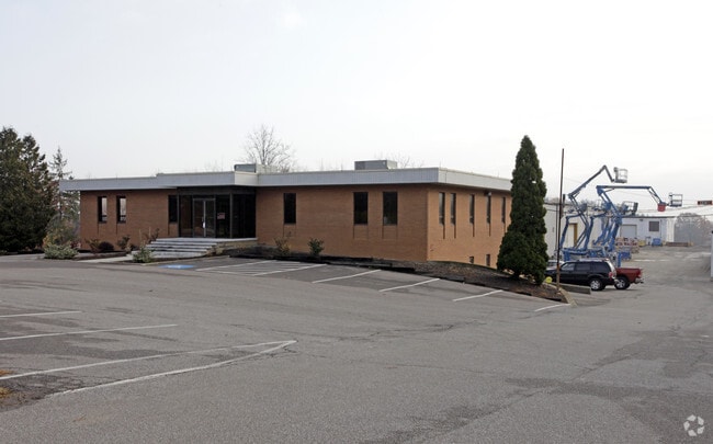
Property Detail
3351 Brecksville Rd
Akron, OH
3 LOT 1 E OF CLEVE MASS RD .230A
50-00501
Summit
Parkingstructure
Ohio
B and X Area of moderate flood hazard, usually the area between the limits of the 100-year and 500-year floods.
1
2025
0.21 AC
2026
Akron
532502
Cleveland
18,882 SF
NEARBY LISTINGS FOR SALE OR LEASE
DEMOGRAPHICS near 3351 Brecksville Rd
1 mile
3 mile
5 mile
2025 Total Population
1,057
7,157
22,595
2030 Population
1,066
7,144
22,484
Pop Growth 2025-2030
+ 0.85%
(0.18%)
(0.49%)
Average Age
46
46
45
2025 Total Households
415
2,711
8,565
HH Growth 2025-2030
+ 0.96%
(0.18%)
(0.57%)
Median Household Inc
$99,264
$141,749
$145,227
Avg Household Size
2.50
2.60
2.60
2025 Avg HH Vehicles
2.00
2.00
2.00
Median Home Value
$437,500
$503,601
$443,739
Median Year Built
1974
1977
1983
Nearby Places
Map Layers
Map Styles
 Street
 Aerial
Layers
 Traffic
 Biking
Places
Listings with unknown addresses are not visible on the map
- Restaurants
- Banks
- Shops
- Fitness
- Groceries
PUBLIC TRANSPORTATION
COMMUTER RAIL
Indigo Lake (National Park Scenic Railway - Cuyahoga Valley Scenic Railroad)
Drive
Walk
Distance
Indigo Lake (National Park Scenic Railway - Cuyahoga Valley Scenic Railroad)
12 min
5.5 mi
Boston Mill (National Park Scenic Railway - Cuyahoga Valley Scenic Railroad)
Drive
Walk
Distance
Boston Mill (National Park Scenic Railway - Cuyahoga Valley Scenic Railroad)
13 min
6.5 mi
AIRPORT
Cleveland-Hopkins International
Drive
Walk
Distance
Cleveland-Hopkins International
37 min
24.4 mi
Akron-Canton Regional
Drive
Walk
Distance
Akron-Canton Regional
40 min
30.4 mi
Freight Ports
Port of Toledo
Drive
Walk
Distance
Port of Toledo
140 min
118.9 mi
Nearby Properties
Address
Land Use
TOTAL SIZE
Lot Size
Zoning
Address
Land Use
TOTAL SIZE
Lot Size
Zoning
255,048 SF
38.60 AC
Address
Land Use
TOTAL SIZE
Lot Size
Zoning
Address
Land Use
TOTAL SIZE
Lot Size
Zoning
49,530 SF
8.28 AC
Address
Land Use
TOTAL SIZE
Lot Size
Zoning
225,990 SF
16.89 AC
Address
Land Use
TOTAL SIZE
Lot Size
Zoning
72,796 SF
11.49 AC
Address
Land Use
TOTAL SIZE
Lot Size
Zoning
105,120 SF
8.34 AC
Address
Land Use
TOTAL SIZE
Lot Size
Zoning
Address
Land Use
TOTAL SIZE
Lot Size
Zoning
99,468 SF
10.04 AC
Address
Land Use
TOTAL SIZE
Lot Size
Zoning
59,852 SF
7 AC
Address
Land Use
TOTAL SIZE
Lot Size
Zoning
69,030 SF
8.23 AC
Address
Land Use
TOTAL SIZE
Lot Size
Zoning
Address
Land Use
TOTAL SIZE
Lot Size
Zoning
54,750 SF
8.88 AC
Address
Land Use
TOTAL SIZE
Lot Size
Zoning
81,134 SF
61.23 AC
Address
Land Use
TOTAL SIZE
Lot Size
Zoning
Address
Land Use
TOTAL SIZE
Lot Size
Zoning
36,127 SF
7.03 AC
Address
Land Use
TOTAL SIZE
Lot Size
Zoning
Address
Land Use
TOTAL SIZE
Lot Size
Zoning
87,704 SF
10.02 AC
Address
Land Use
TOTAL SIZE
Lot Size
Zoning
Address
Land Use
TOTAL SIZE
Lot Size
Zoning
157,225 SF
13.26 AC
Address
Land Use
TOTAL SIZE
Lot Size
Zoning
48,928 SF
5.33 AC
Address
Land Use
TOTAL SIZE
Lot Size
Zoning
58,977 SF
2.19 AC
Address
Land Use
TOTAL SIZE
Lot Size
Zoning
42,306 SF
2.82 AC
Address
Land Use
TOTAL SIZE
Lot Size
Zoning
Address
Land Use
TOTAL SIZE
Lot Size
Zoning
22,676 SF
184.46 AC
Address
Land Use
TOTAL SIZE
Lot Size
Zoning
53,967 SF
7 AC
Address
Land Use
TOTAL SIZE
Lot Size
Zoning
Address
Land Use
TOTAL SIZE
Lot Size
Zoning
Address
Land Use
TOTAL SIZE
Lot Size
Zoning
44,728 SF
5.09 AC
Address
Land Use
TOTAL SIZE
Lot Size
Zoning
Address
Land Use
TOTAL SIZE
Lot Size
Zoning
45,231 SF
11.93 AC
The World's #1 Commercial Real Estate Marketplace
Connect with us
© 2026 CoStar Group
The information above has been obtained from sources believed reliable. While we do not doubt its accuracy we have not verified it and make no guarantee, warranty or representation about it. It is your responsibility to independently confirm its accuracy and completeness. Any projections, opinions, assumptions, or estimates used are for example only and do not represent the current or future performance of the property. The value of this transaction to you depends on tax and other factors which should be evaluated by your tax, financial, and legal advisors. You and your advisors should conduct a careful, independent investigation of the property to determine to your satisfaction the suitability of the property for your needs.