Property Record
3351 N Freeway, Tucson, AZ 85705
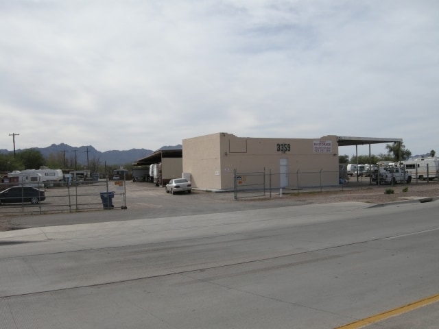
Property Detail
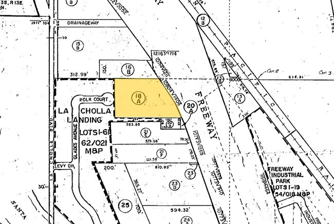
3351 N Freeway
106-11-018A
E150 W1009.8 S89.39 N394.56 SW4 SW4 .30 AC SEC 27-13-13
Commercialnec
PIMA
C2
Arizona
B and X Area of moderate flood hazard, usually the area between the limits of the 100-year and 500-year floods.
5
2025
3.03 AC
2026
West Tucson
004515
Tucson
16,014 SF
Tucson, AZ
NEARBY LISTINGS FOR SALE OR LEASE
DEMOGRAPHICS near 3351 N Freeway
1 mile
3 mile
5 mile
2025 Total Population
9,123
85,372
208,359
2030 Population
9,599
87,999
214,672
Pop Growth 2025-2030
+ 5.22%
+ 3.08%
+ 3.03%
Average Age
38
39
39
2025 Total Households
3,908
37,310
91,943
HH Growth 2025-2030
+ 5.32%
+ 3.14%
+ 3.18%
Median Household Inc
$39,664
$45,632
$52,970
Avg Household Size
2.30
2.20
2.10
2025 Avg HH Vehicles
2.00
2.00
2.00
Median Home Value
$78,311
$227,108
$312,490
Median Year Built
1985
1982
1980
Nearby Places
Map Layers
Map Styles
 Street
 Aerial
Layers
 Traffic
 Biking
Places
Listings with unknown addresses are not visible on the map
- Restaurants
- Banks
- Shops
- Fitness
- Groceries
PUBLIC TRANSPORTATION
COMMUTER RAIL
Drive
Walk
Distance
8 min
4.9 mi
AIRPORT
Tucson International
Drive
Walk
Distance
Tucson International
21 min
12.4 mi
Nearby Properties
Address
Land Use
TOTAL SIZE
Lot Size
Zoning
Address
Land Use
TOTAL SIZE
Lot Size
Zoning
134,710 SF
9.59 AC
I1
Address
Land Use
TOTAL SIZE
Lot Size
Zoning
106,852 SF
19.50 AC
I1
Address
Land Use
TOTAL SIZE
Lot Size
Zoning
866,763 SF
17.17 AC
O3
Address
Land Use
TOTAL SIZE
Lot Size
Zoning
451,596 SF
18.92 AC
C3
Address
Land Use
TOTAL SIZE
Lot Size
Zoning
652,898 SF
233.08 AC
RX2
Address
Land Use
TOTAL SIZE
Lot Size
Zoning
39,508 SF
7.29 AC
MU
Address
Land Use
TOTAL SIZE
Lot Size
Zoning
251,043 SF
14.96 AC
Address
Land Use
TOTAL SIZE
Lot Size
Zoning
119,165 SF
21.85 AC
I1
Address
Land Use
TOTAL SIZE
Lot Size
Zoning
139,733 SF
9.80 AC
C3
Address
Land Use
TOTAL SIZE
Lot Size
Zoning
290,039 SF
1.98 AC
C3
Address
Land Use
TOTAL SIZE
Lot Size
Zoning
177,018 SF
16.78 AC
C2
Address
Land Use
TOTAL SIZE
Lot Size
Zoning
36,100 SF
2.42 AC
I1
Address
Land Use
TOTAL SIZE
Lot Size
Zoning
312,586 SF
28.73 AC
Address
Land Use
TOTAL SIZE
Lot Size
Zoning
24,100 SF
4.96 AC
MU
Address
Land Use
TOTAL SIZE
Lot Size
Zoning
21,000 SF
9.34 AC
Address
Land Use
TOTAL SIZE
Lot Size
Zoning
209,967 SF
14.19 AC
Address
Land Use
TOTAL SIZE
Lot Size
Zoning
19,892 SF
3.36 AC
CB1
Address
Land Use
TOTAL SIZE
Lot Size
Zoning
309,905 SF
13.09 AC
SP
Address
Land Use
TOTAL SIZE
Lot Size
Zoning
324,571 SF
7.80 AC
C3
Address
Land Use
TOTAL SIZE
Lot Size
Zoning
4,712 SF
13.08 AC
Address
Land Use
TOTAL SIZE
Lot Size
Zoning
251,672 SF
13.88 AC
TR
Address
Land Use
TOTAL SIZE
Lot Size
Zoning
230,676 SF
14.99 AC
Address
Land Use
TOTAL SIZE
Lot Size
Zoning
93,449 SF
7.04 AC
C3
Address
Land Use
TOTAL SIZE
Lot Size
Zoning
55,016 SF
3.63 AC
O3
Address
Land Use
TOTAL SIZE
Lot Size
Zoning
199,949 SF
20.27 AC
Address
Land Use
TOTAL SIZE
Lot Size
Zoning
193,681 SF
20.31 AC
Address
Land Use
TOTAL SIZE
Lot Size
Zoning
7,079 SF
3.79 AC
C1
Address
Land Use
TOTAL SIZE
Lot Size
Zoning
135,653 SF
8.15 AC
C3
Address
Land Use
TOTAL SIZE
Lot Size
Zoning
46,934 SF
6.99 AC
C2
Address
Land Use
TOTAL SIZE
Lot Size
Zoning
96,380 SF
9.32 AC
CR4
The World's #1 Commercial Real Estate Marketplace
Connect with us
© 2026 CoStar Group
The information above has been obtained from sources believed reliable. While we do not doubt its accuracy we have not verified it and make no guarantee, warranty or representation about it. It is your responsibility to independently confirm its accuracy and completeness. Any projections, opinions, assumptions, or estimates used are for example only and do not represent the current or future performance of the property. The value of this transaction to you depends on tax and other factors which should be evaluated by your tax, financial, and legal advisors. You and your advisors should conduct a careful, independent investigation of the property to determine to your satisfaction the suitability of the property for your needs.