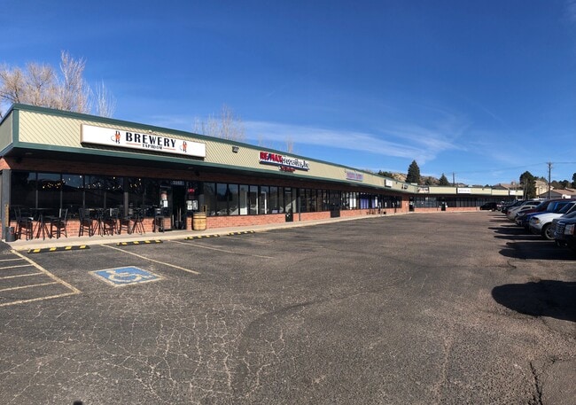
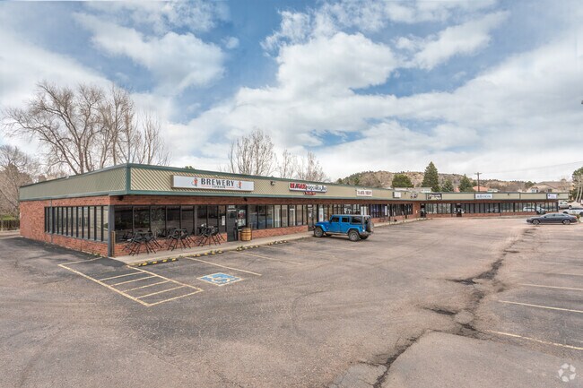
Property Record
3352 N Templeton Gap Rd, Colorado Springs, CO 80907

Current Lease Availabilities
NEARBY LISTINGS FOR SALE OR LEASE
-
-
-
-
-
-
-
-
-
2712 E Boulder St - Redevelopment Opportunity!
Colorado Springs, CO 80909
Rent Upon Request
1,015 SF
Retail
-
-
-
-
-
-
-
-
View all Colorado Springs listings for lease on LoopNet.com
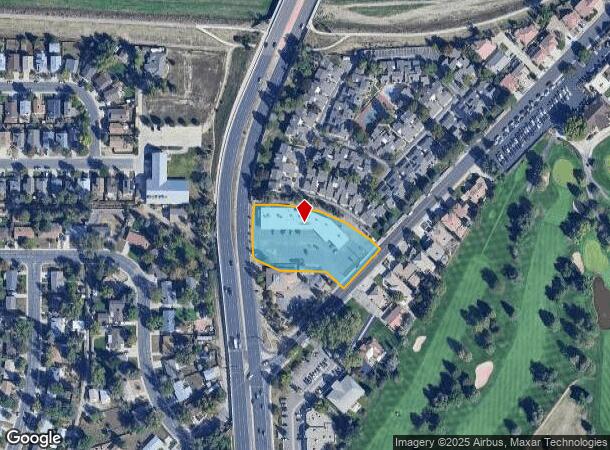
Property Detail
3352 N Templeton Gap Rd
Colorado Springs
One-M Corner Sub
Colorado Springs, CO
LOT 2 ONE-M CORNER SUB TOG WITH A TRACT OF LAND IN R/W OF TEMPLETON GAP RD WHICH IS 162.97 LONG AND 20.0 FT WIDE AND IMMEDIATELY ADJ TO E BDRY LN OF LOT 2
63321-08-004
El Paso
Commercialbuilding
Colorado
2024
2
2025
1.47 AC
000301
North
14,360 SF
DEMOGRAPHICS near 3352 N Templeton Gap Rd
1 Mile
3 Mile
5 Mile
2024 Total Population
10,605
105,506
284,959
2029 Population
10,909
109,630
297,499
Pop Growth 2024-2029
+ 2.87%
+ 3.91%
+ 4.40%
Average Age
42
40
39
2024 Total Households
4,512
46,081
121,009
HH Growth 2024-2029
+ 3.01%
+ 4.14%
+ 4.66%
Median Household Inc
$65,095
$61,575
$66,222
Avg Household Size
2.20
2.20
2.30
2024 Avg HH Vehicles
2.00
2.00
2.00
Median Home Value
$340,057
$356,988
$366,517
Median Year Built
1964
1972
1979
Nearby Places
Map Layers
Map Styles
 Street
 Aerial
- Restaurants
- Banks
- Shops
- Fitness
- Groceries
PUBLIC TRANSPORTATION
AIRPORT
City of Colorado Springs Municipal
DRIVE
WALK
Distance
City of Colorado Springs Municipal
21 min
9.7 mi
Nearby Properties
Address
Land Use
TOTAL SIZE
Lot Size
Zoning
Address
Land Use
TOTAL SIZE
Lot Size
Zoning
1,072,186 SF
15.14 AC
MX-N HR CU
Address
Land Use
TOTAL SIZE
Lot Size
Zoning
586,419 SF
17.77 AC
R-5 CU
Address
Land Use
TOTAL SIZE
Lot Size
Zoning
604,992 SF
28.95 AC
MX-T CU
Address
Land Use
TOTAL SIZE
Lot Size
Zoning
326,035 SF
33.75 AC
PCR UV
Address
Land Use
TOTAL SIZE
Lot Size
Zoning
271,048 SF
3.67 AC
FBZ-T2A
Address
Land Use
TOTAL SIZE
Lot Size
Zoning
62,201 SF
5.68 AC
MX-N
Address
Land Use
TOTAL SIZE
Lot Size
Zoning
167,120 SF
10.59 AC
MX-L/CR CU
Address
Land Use
TOTAL SIZE
Lot Size
Zoning
197,578 SF
7.98 AC
PDZ
Address
Land Use
TOTAL SIZE
Lot Size
Zoning
109,808 SF
8.11 AC
MX-M
Address
Land Use
TOTAL SIZE
Lot Size
Zoning
75,831 SF
3.37 AC
R-5 P
Address
Land Use
TOTAL SIZE
Lot Size
Zoning
131,545 SF
12.46 AC
R-5/CR CU
Address
Land Use
TOTAL SIZE
Lot Size
Zoning
138,773 SF
4.45 AC
R-5
Address
Land Use
TOTAL SIZE
Lot Size
Zoning
80,802 SF
14.45 AC
PF NNA
Address
Land Use
TOTAL SIZE
Lot Size
Zoning
198,916 SF
31.69 AC
PF/CR SS
Address
Land Use
TOTAL SIZE
Lot Size
Zoning
80,110 SF
2.61 AC
OR CU
Address
Land Use
TOTAL SIZE
Lot Size
Zoning
1,223 SF
725.94 AC
PF PK SS
Address
Land Use
TOTAL SIZE
Lot Size
Zoning
74,258 SF
4.60 AC
MX-T CU
Address
Land Use
TOTAL SIZE
Lot Size
Zoning
33,830 SF
1.09 AC
FBZ-T2A
Address
Land Use
TOTAL SIZE
Lot Size
Zoning
89,592 SF
7.60 AC
R-E CU
Address
Land Use
TOTAL SIZE
Lot Size
Zoning
71,542 SF
10.11 AC
PF
Address
Land Use
TOTAL SIZE
Lot Size
Zoning
134,592 SF
10.09 AC
MX-L LI CU
Address
Land Use
TOTAL SIZE
Lot Size
Zoning
39,627 SF
1.61 AC
R-5 SS
Address
Land Use
TOTAL SIZE
Lot Size
Zoning
131,696 SF
9.24 AC
MX-M
Address
Land Use
TOTAL SIZE
Lot Size
Zoning
76,203 SF
8.15 AC
PF
Address
Land Use
TOTAL SIZE
Lot Size
Zoning
55,432 SF
4.78 AC
R-5
Address
Land Use
TOTAL SIZE
Lot Size
Zoning
99,488 SF
13.01 AC
PDZ
Address
Land Use
TOTAL SIZE
Lot Size
Zoning
45,044 SF
2 AC
R-1 6
Address
Land Use
TOTAL SIZE
Lot Size
Zoning
60,324 SF
1.72 AC
R-5
Address
Land Use
TOTAL SIZE
Lot Size
Zoning
48,117 SF
2.96 AC
MX-M CU
Address
Land Use
TOTAL SIZE
Lot Size
Zoning
34,443 SF
5.14 AC
PF
The World's #1 Commercial Real Estate Marketplace
Connect with us
© 2025 CoStar Group
The information above has been obtained from sources believed reliable. While we do not doubt its accuracy we have not verified it and make no guarantee, warranty or representation about it. It is your responsibility to independently confirm its accuracy and completeness. Any projections, opinions, assumptions, or estimates used are for example only and do not represent the current or future performance of the property. The value of this transaction to you depends on tax and other factors which should be evaluated by your tax, financial, and legal advisors. You and your advisors should conduct a careful, independent investigation of the property to determine to your satisfaction the suitability of the property for your needs.