Property Record
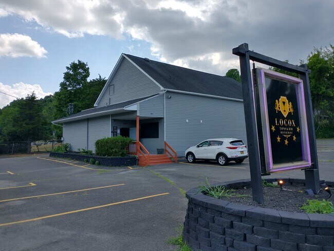
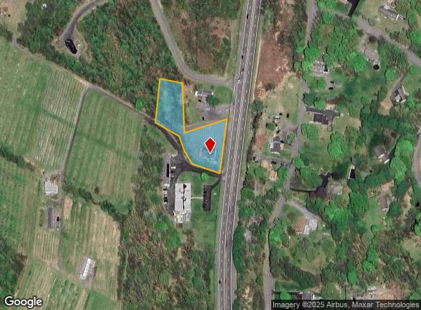
3353 Us Highway 9W, Highland, NY 12528
NEARBY LISTINGS FOR SALE OR LEASE
Property Detail
3353 Us Highway 9W
3200-088.001-0001-009.000-0000
Ulster
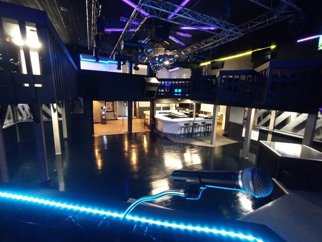
Bartavern
New York
X
9.000
36027C0352E
1.20 AC
2025
Newburgh/Kingston
2024
Other Market Areas
953700
Kingston, NY
4,372 SF
DEMOGRAPHICS near 3353 Us Highway 9W
1 Mile
3 Mile
5 Mile
2024 Total Population
709
18,490
69,865
2029 Population
705
18,492
69,793
Pop Growth 2024-2029
(0.56%)
+ 0.01%
(0.10%)
Average Age
43
37
40
2024 Total Households
278
5,679
26,780
HH Growth 2024-2029
(0.72%)
+ 0.02%
(0.03%)
Median Household Inc
$88,124
$82,380
$63,135
Avg Household Size
2.40
2.30
2.30
2024 Avg HH Vehicles
2.00
2.00
2.00
Median Home Value
$289,999
$275,729
$262,717
Median Year Built
1964
1968
1963
Nearby Places
- Restaurants
- Banks
- Shops
- Fitness
- Groceries
PUBLIC TRANSPORTATION
COMMUTER RAIL
Poughkeepsie Station (Hudson Line - Metro-North Commuter Railroad Company (Metro-North))
DRIVE
WALK
Distance
Poughkeepsie Station (Hudson Line - Metro-North Commuter Railroad Company (Metro-North))
11 min
5.5 mi
AIRPORT
New York Stewart International
DRIVE
WALK
Distance
New York Stewart International
33 min
24.0 mi
Freight Ports
Albany, NY Port
DRIVE
WALK
Distance
Albany, NY Port
85 min
67.2 mi
SALE & LEASE HISTORY
LISTING DATE
SALE/LEASE

Sep 24, 2016
For Sale
Oct 24, 2017
For Sale
Mar 21, 2023
For Sale
Nearby Properties
Address
Land Use
TOTAL SIZE
Lot Size
Zoning
Address
Land Use
TOTAL SIZE
Lot Size
Zoning
314,927 SF
24.59 AC
IN
Address
Land Use
TOTAL SIZE
Lot Size
Zoning
4.99 AC
R2A
Address
Land Use
TOTAL SIZE
Lot Size
Zoning
246,913 SF
43.93 AC
IN
Address
Land Use
TOTAL SIZE
Lot Size
Zoning
181,295 SF
20.48 AC
IN
Address
Land Use
TOTAL SIZE
Lot Size
Zoning
2.11 AC
IN
Address
Land Use
TOTAL SIZE
Lot Size
Zoning
4.49 AC
IH
Address
Land Use
TOTAL SIZE
Lot Size
Zoning
317,644 SF
35.25 AC
CIA
Address
Land Use
TOTAL SIZE
Lot Size
Zoning
12,638 SF
159.73 AC
R2A
Address
Land Use
TOTAL SIZE
Lot Size
Zoning
5.29 AC
I-2
Address
Land Use
TOTAL SIZE
Lot Size
Zoning
218,118 SF
13.15 AC
FC
Address
Land Use
TOTAL SIZE
Lot Size
Zoning
102,798 SF
16.71 AC
IN
Address
Land Use
TOTAL SIZE
Lot Size
Zoning
103,108 SF
24.31 AC
HRDD
Address
Land Use
TOTAL SIZE
Lot Size
Zoning
162.70 AC
R20
Address
Land Use
TOTAL SIZE
Lot Size
Zoning
82,739 SF
6.16 AC
IN
Address
Land Use
TOTAL SIZE
Lot Size
Zoning
59,499 SF
0.97 AC
IN
Address
Land Use
TOTAL SIZE
Lot Size
Zoning
82,000 SF
1.27 AC
IN
Address
Land Use
TOTAL SIZE
Lot Size
Zoning
15.50 AC
N
Address
Land Use
TOTAL SIZE
Lot Size
Zoning
146,420 SF
1.16 AC
IN
Address
Land Use
TOTAL SIZE
Lot Size
Zoning
123,218 SF
15.07 AC
FC
Address
Land Use
TOTAL SIZE
Lot Size
Zoning
79,712 SF
0.67 AC
IN
Address
Land Use
TOTAL SIZE
Lot Size
Zoning
89.30 AC
R2
Address
Land Use
TOTAL SIZE
Lot Size
Zoning
33,614 SF
3.99 AC
IN
Address
Land Use
TOTAL SIZE
Lot Size
Zoning
26,461 SF
6.12 AC
IH
Address
Land Use
TOTAL SIZE
Lot Size
Zoning
61,987 SF
3.80 AC
IN
Address
Land Use
TOTAL SIZE
Lot Size
Zoning
1.37 AC
R-1
Address
Land Use
TOTAL SIZE
Lot Size
Zoning
830,000 SF
3.49 AC
Address
Land Use
TOTAL SIZE
Lot Size
Zoning
77,190 SF
9.71 AC
FC
Address
Land Use
TOTAL SIZE
Lot Size
Zoning
Address
Land Use
TOTAL SIZE
Lot Size
Zoning
Address
Land Use
TOTAL SIZE
Lot Size
Zoning
124,668 SF
29.60 AC
The World's #1 Commercial Real Estate Marketplace
Connect with us
© 2025 CoStar Group
The information above has been obtained from sources believed reliable. While we do not doubt its accuracy we have not verified it and make no guarantee, warranty or representation about it. It is your responsibility to independently confirm its accuracy and completeness. Any projections, opinions, assumptions, or estimates used are for example only and do not represent the current or future performance of the property. The value of this transaction to you depends on tax and other factors which should be evaluated by your tax, financial, and legal advisors. You and your advisors should conduct a careful, independent investigation of the property to determine to your satisfaction the suitability of the property for your needs.