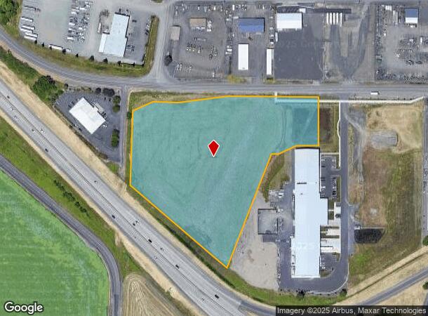
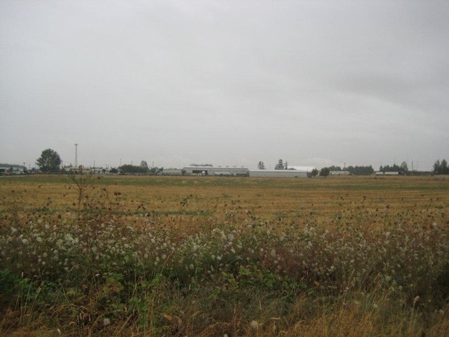
Property Record
33559 Highway 99E, Tangent, OR 97389

NEARBY LISTINGS FOR SALE OR LEASE
Property Detail
33559 Highway 99E
Albany, OR
Partition Plat 2019-050
0894742
12S04W0100
Industrialacreage
Linn
A
Oregon
41043C0536G
1
2025
7.12 AC
2025
Linn County
0304013034
Portland
DEMOGRAPHICS near 33559 Highway 99E
1 Mile
3 Mile
5 Mile
2024 Total Population
710
5,259
35,876
2029 Population
734
5,474
37,379
Pop Growth 2024-2029
+ 3.38%
+ 4.09%
+ 4.19%
Average Age
42
40
40
2024 Total Households
280
2,056
14,221
HH Growth 2024-2029
+ 3.57%
+ 4.28%
+ 4.34%
Median Household Inc
$75,510
$76,567
$68,419
Avg Household Size
2.50
2.50
2.40
2024 Avg HH Vehicles
2.00
2.00
2.00
Median Home Value
$363,491
$353,462
$304,273
Median Year Built
1987
1991
1978
Nearby Places
Map Layers
Map Styles
 Street
 Aerial
- Restaurants
- Banks
- Shops
- Fitness
- Groceries
PUBLIC TRANSPORTATION
COMMUTER RAIL
Albany Amtrak Station (Amtrak Cascades - Amtrak, Coast Starlight - Amtrak)
DRIVE
WALK
Distance
Albany Amtrak Station (Amtrak Cascades - Amtrak, Coast Starlight - Amtrak)
8 min
5.5 mi
Freight Ports
Port of Portland
DRIVE
WALK
Distance
Port of Portland
99 min
77.5 mi
Nearby Properties
Address
Land Use
TOTAL SIZE
Lot Size
Zoning
Address
Land Use
TOTAL SIZE
Lot Size
Zoning
8,842 SF
73.88 AC
RS-6.5
Address
Land Use
TOTAL SIZE
Lot Size
Zoning
104.75 AC
LI
Address
Land Use
TOTAL SIZE
Lot Size
Zoning
29.90 AC
HI
Address
Land Use
TOTAL SIZE
Lot Size
Zoning
9.32 AC
LI
Address
Land Use
TOTAL SIZE
Lot Size
Zoning
11.43 AC
HC/I
Address
Land Use
TOTAL SIZE
Lot Size
Zoning
8.70 AC
IND
Address
Land Use
TOTAL SIZE
Lot Size
Zoning
13,600 SF
11.89 AC
LI
Address
Land Use
TOTAL SIZE
Lot Size
Zoning
69,760 SF
2.80 AC
RMA
Address
Land Use
TOTAL SIZE
Lot Size
Zoning
10.56 AC
HC/I
Address
Land Use
TOTAL SIZE
Lot Size
Zoning
64,046 SF
5.22 AC
HC/I
Address
Land Use
TOTAL SIZE
Lot Size
Zoning
36,574 SF
5.10 AC
IP
Address
Land Use
TOTAL SIZE
Lot Size
Zoning
55,725 SF
5.98 AC
HC/I
Address
Land Use
TOTAL SIZE
Lot Size
Zoning
4.64 AC
IND
Address
Land Use
TOTAL SIZE
Lot Size
Zoning
7.33 AC
IND
Address
Land Use
TOTAL SIZE
Lot Size
Zoning
105 SF
33.79 AC
EFU
Address
Land Use
TOTAL SIZE
Lot Size
Zoning
32,800 SF
3.51 AC
CC
Address
Land Use
TOTAL SIZE
Lot Size
Zoning
8.09 AC
CC
Address
Land Use
TOTAL SIZE
Lot Size
Zoning
7.61 AC
IP
Address
Land Use
TOTAL SIZE
Lot Size
Zoning
40,416 SF
2.20 AC
RMA
Address
Land Use
TOTAL SIZE
Lot Size
Zoning
50.07 AC
IP
Address
Land Use
TOTAL SIZE
Lot Size
Zoning
23,000 SF
8.03 AC
EFU
Address
Land Use
TOTAL SIZE
Lot Size
Zoning
22,622 SF
1.97 AC
MUC
Address
Land Use
TOTAL SIZE
Lot Size
Zoning
54,000 SF
3.17 AC
IND
Address
Land Use
TOTAL SIZE
Lot Size
Zoning
50,000 SF
3.13 AC
IND
Address
Land Use
TOTAL SIZE
Lot Size
Zoning
51,840 SF
3.08 AC
IND
Address
Land Use
TOTAL SIZE
Lot Size
Zoning
2,520 SF
10.88 AC
IND
Address
Land Use
TOTAL SIZE
Lot Size
Zoning
40,800 SF
8 AC
RR-5
The World's #1 Commercial Real Estate Marketplace
Connect with us
© 2025 CoStar Group
The information above has been obtained from sources believed reliable. While we do not doubt its accuracy we have not verified it and make no guarantee, warranty or representation about it. It is your responsibility to independently confirm its accuracy and completeness. Any projections, opinions, assumptions, or estimates used are for example only and do not represent the current or future performance of the property. The value of this transaction to you depends on tax and other factors which should be evaluated by your tax, financial, and legal advisors. You and your advisors should conduct a careful, independent investigation of the property to determine to your satisfaction the suitability of the property for your needs.