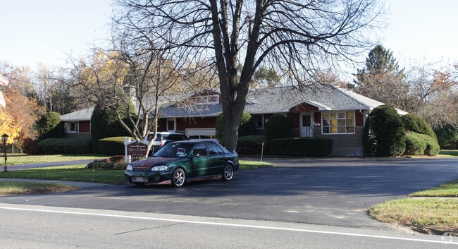
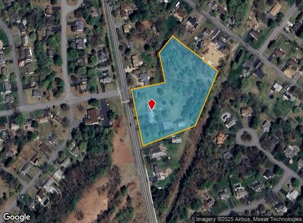
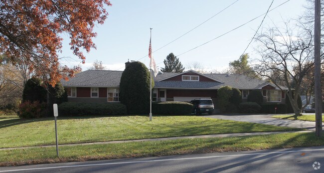
Property Record
3357 Carman Rd, Schenectady, NY 12303
NEARBY LISTINGS FOR SALE OR LEASE
Property Detail
3357 Carman Rd
013089-015-014-0004-038-000-0000
Albany
Commercialofficeresidentialmixeduse
New York
X
38.000
36001C0039D
3.50 AC
2025
W Outer Albany County
2024
Albany/Schenectady/Troy
014616
Albany-Schenectady-Troy, NY
3,150 SF
DEMOGRAPHICS near 3357 Carman Rd
1 Mile
3 Mile
5 Mile
2024 Total Population
5,508
47,160
132,813
2029 Population
5,505
48,724
137,875
Pop Growth 2024-2029
(0.05%)
+ 3.32%
+ 3.81%
Average Age
43
42
41
2024 Total Households
2,293
19,578
54,584
HH Growth 2024-2029
+ 0.26%
+ 3.61%
+ 3.99%
Median Household Inc
$91,106
$79,163
$72,701
Avg Household Size
2.40
2.40
2.30
2024 Avg HH Vehicles
2.00
2.00
2.00
Median Home Value
$287,299
$193,633
$195,737
Median Year Built
1982
1960
1956
Nearby Places
- Restaurants
- Banks
- Shops
- Fitness
- Groceries
PUBLIC TRANSPORTATION
COMMUTER RAIL
DRIVE
WALK
Distance
12 min
6.7 mi
AIRPORT
Albany International
DRIVE
WALK
Distance
Albany International
22 min
12.0 mi
Freight Ports
Albany, NY Port
DRIVE
WALK
Distance
Albany, NY Port
23 min
15.9 mi
Nearby Properties
Address
Land Use
TOTAL SIZE
Lot Size
Zoning
Address
Land Use
TOTAL SIZE
Lot Size
Zoning
102,862 SF
32.45 AC
CS
Address
Land Use
TOTAL SIZE
Lot Size
Zoning
120,755 SF
33.88 AC
R1
Address
Land Use
TOTAL SIZE
Lot Size
Zoning
382,858 SF
70.33 AC
R-1
Address
Land Use
TOTAL SIZE
Lot Size
Zoning
9,000 SF
10.32 AC
GB
Address
Land Use
TOTAL SIZE
Lot Size
Zoning
4,680 SF
11.39 AC
CH
Address
Land Use
TOTAL SIZE
Lot Size
Zoning
19,968 SF
12 AC
MR
Address
Land Use
TOTAL SIZE
Lot Size
Zoning
78,326 SF
27.47 AC
R40
Address
Land Use
TOTAL SIZE
Lot Size
Zoning
21,791 SF
4.93 AC
B-1, B-2
Address
Land Use
TOTAL SIZE
Lot Size
Zoning
21,791 SF
4.86 AC
B-1, B-2
Address
Land Use
TOTAL SIZE
Lot Size
Zoning
Address
Land Use
TOTAL SIZE
Lot Size
Zoning
86,049 SF
17.10 AC
RO30
Address
Land Use
TOTAL SIZE
Lot Size
Zoning
202,050 SF
20.75 AC
B-2
Address
Land Use
TOTAL SIZE
Lot Size
Zoning
79,041 SF
13.20 AC
CN
Address
Land Use
TOTAL SIZE
Lot Size
Zoning
7,216 SF
15.90 AC
03 - MULTI
Address
Land Use
TOTAL SIZE
Lot Size
Zoning
20,630 SF
12.99 AC
MR*
Address
Land Use
TOTAL SIZE
Lot Size
Zoning
97,440 SF
8.15 AC
B-2
Address
Land Use
TOTAL SIZE
Lot Size
Zoning
111,915 SF
15.04 AC
05 - COMME
Address
Land Use
TOTAL SIZE
Lot Size
Zoning
117 AC
06 - INDUS
Address
Land Use
TOTAL SIZE
Lot Size
Zoning
78,240 SF
10.55 AC
B-2
Address
Land Use
TOTAL SIZE
Lot Size
Zoning
68,080 SF
6.22 AC
CS
Address
Land Use
TOTAL SIZE
Lot Size
Zoning
10,864 SF
17.90 AC
03 - MULTI
Address
Land Use
TOTAL SIZE
Lot Size
Zoning
68,000 SF
11.20 AC
TH
Address
Land Use
TOTAL SIZE
Lot Size
Zoning
6,889 SF
284.30 AC
F
Address
Land Use
TOTAL SIZE
Lot Size
Zoning
134,624 SF
26.23 AC
CON
Address
Land Use
TOTAL SIZE
Lot Size
Zoning
47,951 SF
8.10 AC
GB
Address
Land Use
TOTAL SIZE
Lot Size
Zoning
127,864 SF
11 AC
B-2
Address
Land Use
TOTAL SIZE
Lot Size
Zoning
71,480 SF
15.40 AC
03 - MULTI
Address
Land Use
TOTAL SIZE
Lot Size
Zoning
51,779 SF
17.50 AC
R-1
Address
Land Use
TOTAL SIZE
Lot Size
Zoning
2.43 AC
R-1
Address
Land Use
TOTAL SIZE
Lot Size
Zoning
67,497 SF
7.30 AC
02 - SINGL
The World's #1 Commercial Real Estate Marketplace
Connect with us
© 2025 CoStar Group
The information above has been obtained from sources believed reliable. While we do not doubt its accuracy we have not verified it and make no guarantee, warranty or representation about it. It is your responsibility to independently confirm its accuracy and completeness. Any projections, opinions, assumptions, or estimates used are for example only and do not represent the current or future performance of the property. The value of this transaction to you depends on tax and other factors which should be evaluated by your tax, financial, and legal advisors. You and your advisors should conduct a careful, independent investigation of the property to determine to your satisfaction the suitability of the property for your needs.