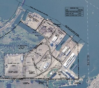
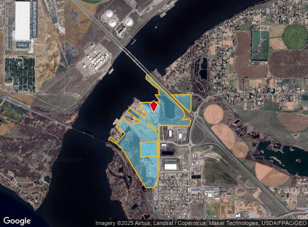
Property Record
336 Grain Terminal Rd, Burbank, WA 99323
NEARBY LISTINGS FOR SALE OR LEASE
Property Detail
336 Grain Terminal Rd
Other Market Areas
Townsite Of Burbank
Walla Walla, WA
SEC 2-8-30 N1/2NE1/4 LESS PTNS DIVIDED OFF; SELY PTN NE1/4NW1/4;SW1/4NE1/4 LESS TAX 1; SE1/4NW1/4 LESS TAX 2; NW1/4SE1/4 NELY OF RRLESS SELY CORNER; NELY PTN SW1/4SE1/4 LESS PLATTED AREA. LESS PTNTO STATE OF WA FOR HWY PURPOSES
300802110012
Walla Walla
Commercialnec
Washington
2025
12
2025
175.23 AC
920000
Yakima/Kennewick
DEMOGRAPHICS near 336 Grain Terminal Rd
1 Mile
3 Mile
5 Mile
2024 Total Population
574
11,662
46,193
2029 Population
568
12,372
49,530
Pop Growth 2024-2029
(1.05%)
+ 6.09%
+ 7.22%
Average Age
40
35
34
2024 Total Households
191
3,453
13,929
HH Growth 2024-2029
(1.05%)
+ 5.53%
+ 7.09%
Median Household Inc
$80,000
$73,303
$61,763
Avg Household Size
2.80
3.30
3.20
2024 Avg HH Vehicles
3.00
3.00
2.00
Median Home Value
$352,380
$315,707
$238,803
Median Year Built
1979
1990
1973
Nearby Places
Map Layers
Map Styles
 Street
 Aerial
- Restaurants
- Banks
- Shops
- Fitness
- Groceries
PUBLIC TRANSPORTATION
AIRPORT
Tri-Cities
DRIVE
WALK
Distance
Tri-Cities
22 min
15.0 mi
Freight Ports
Port of Tacoma
DRIVE
WALK
Distance
Port of Tacoma
288 min
250.7 mi
Nearby Properties
Address
Land Use
TOTAL SIZE
Lot Size
Zoning
Address
Land Use
TOTAL SIZE
Lot Size
Zoning
1,078,419 SF
114.48 AC
Address
Land Use
TOTAL SIZE
Lot Size
Zoning
1,049,518 SF
104.40 AC
Address
Land Use
TOTAL SIZE
Lot Size
Zoning
2,863,808 SF
28.33 AC
Address
Land Use
TOTAL SIZE
Lot Size
Zoning
2,552 SF
51.19 AC
Address
Land Use
TOTAL SIZE
Lot Size
Zoning
140,275 SF
6.36 AC
Address
Land Use
TOTAL SIZE
Lot Size
Zoning
123.27 AC
Address
Land Use
TOTAL SIZE
Lot Size
Zoning
35,284 SF
30.53 AC
Address
Land Use
TOTAL SIZE
Lot Size
Zoning
121,226 SF
11.91 AC
Address
Land Use
TOTAL SIZE
Lot Size
Zoning
76,788 SF
20 AC
Address
Land Use
TOTAL SIZE
Lot Size
Zoning
584,810 SF
Address
Land Use
TOTAL SIZE
Lot Size
Zoning
107,280 SF
14.53 AC
Address
Land Use
TOTAL SIZE
Lot Size
Zoning
30,640 SF
2.27 AC
Address
Land Use
TOTAL SIZE
Lot Size
Zoning
68,630 SF
13.42 AC
Address
Land Use
TOTAL SIZE
Lot Size
Zoning
48,000 SF
5.11 AC
Address
Land Use
TOTAL SIZE
Lot Size
Zoning
47,239 SF
3.34 AC
Address
Land Use
TOTAL SIZE
Lot Size
Zoning
4,330 SF
421.56 AC
Address
Land Use
TOTAL SIZE
Lot Size
Zoning
1,512 SF
363.75 AC
Address
Land Use
TOTAL SIZE
Lot Size
Zoning
10,524 SF
3 AC
Address
Land Use
TOTAL SIZE
Lot Size
Zoning
10.75 AC
BENTON COU
Address
Land Use
TOTAL SIZE
Lot Size
Zoning
86,658 SF
15 AC
Address
Land Use
TOTAL SIZE
Lot Size
Zoning
4,608 SF
267.39 AC
Address
Land Use
TOTAL SIZE
Lot Size
Zoning
76,368 SF
7.96 AC
Address
Land Use
TOTAL SIZE
Lot Size
Zoning
39,788 SF
5.04 AC
Address
Land Use
TOTAL SIZE
Lot Size
Zoning
137,088 SF
9.31 AC
Address
Land Use
TOTAL SIZE
Lot Size
Zoning
151,066 SF
14 AC
Address
Land Use
TOTAL SIZE
Lot Size
Zoning
6,940 SF
1.45 AC
Address
Land Use
TOTAL SIZE
Lot Size
Zoning
21,814 SF
10.58 AC
The World's #1 Commercial Real Estate Marketplace
Connect with us
© 2026 CoStar Group
The information above has been obtained from sources believed reliable. While we do not doubt its accuracy we have not verified it and make no guarantee, warranty or representation about it. It is your responsibility to independently confirm its accuracy and completeness. Any projections, opinions, assumptions, or estimates used are for example only and do not represent the current or future performance of the property. The value of this transaction to you depends on tax and other factors which should be evaluated by your tax, financial, and legal advisors. You and your advisors should conduct a careful, independent investigation of the property to determine to your satisfaction the suitability of the property for your needs.