Property Record
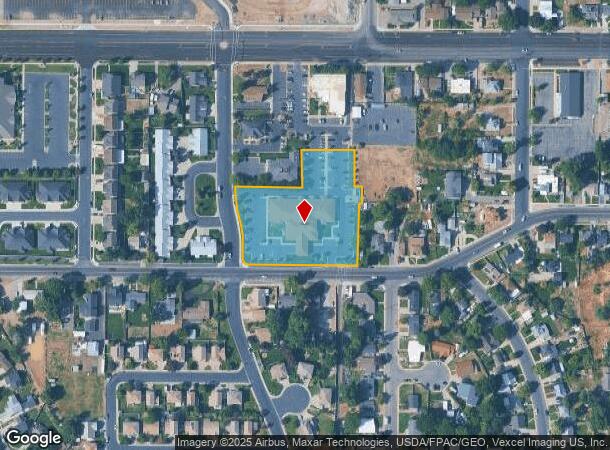
336 W 100 S, Spanish Fork, UT 84660
NEARBY LISTINGS FOR SALE OR LEASE
Property Detail
336 W 100 S
Salt Lake City
Plat A Spanish Fork Professional Limited
Provo-Orem, UT
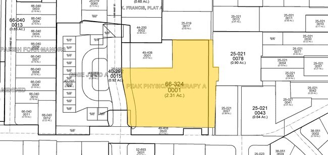
LOT 1, PLAT A, SPANISH FORK PROFESSIONAL LIMITED PARTNERSHIP SUB AREA 2.315 AC.
66-324-0001
Utah
Medicalbuilding
Utah
2024
1
2025
2.32 AC
003302
Utah County
22,325 SF
DEMOGRAPHICS near 336 W 100 S
1 Mile
3 Mile
5 Mile
2024 Total Population
12,816
45,665
93,158
2029 Population
14,902
53,403
109,182
Pop Growth 2024-2029
+ 16.28%
+ 16.95%
+ 17.20%
Average Age
31
31
32
2024 Total Households
3,792
12,370
25,649
HH Growth 2024-2029
+ 16.59%
+ 17.29%
+ 17.51%
Median Household Inc
$80,450
$93,794
$92,256
Avg Household Size
3.40
3.70
3.60
2024 Avg HH Vehicles
2.00
3.00
3.00
Median Home Value
$367,109
$411,194
$447,841
Median Year Built
1984
2001
2001
Nearby Places
Map Layers
Map Styles
 Street
 Aerial
- Restaurants
- Banks
- Shops
- Fitness
- Groceries
PUBLIC TRANSPORTATION
COMMUTER RAIL
Provo Central Station (FrontRunner - Utah Transit Authority (UTA))
DRIVE
WALK
Distance
Provo Central Station (FrontRunner - Utah Transit Authority (UTA))
13 min
9.0 mi
Provo Amtrak (California Zephyr - Amtrak)
DRIVE
WALK
Distance
Provo Amtrak (California Zephyr - Amtrak)
14 min
9.0 mi
AIRPORT
Provo Municipal
DRIVE
WALK
Distance
Provo Municipal
18 min
11.0 mi
Freight Ports
Port of Stockton
DRIVE
WALK
Distance
Port of Stockton
767 min
747.6 mi
Nearby Properties
Address
Land Use
TOTAL SIZE
Lot Size
Zoning
Address
Land Use
TOTAL SIZE
Lot Size
Zoning
44,552 SF
29.78 AC
Address
Land Use
TOTAL SIZE
Lot Size
Zoning
565,605 SF
20 AC
Address
Land Use
TOTAL SIZE
Lot Size
Zoning
92,323 SF
8.96 AC
Address
Land Use
TOTAL SIZE
Lot Size
Zoning
281,008 SF
16.65 AC
Address
Land Use
TOTAL SIZE
Lot Size
Zoning
281,008 SF
14.84 AC
Address
Land Use
TOTAL SIZE
Lot Size
Zoning
204,890 SF
15.28 AC
Address
Land Use
TOTAL SIZE
Lot Size
Zoning
271,536 SF
11.80 AC
Address
Land Use
TOTAL SIZE
Lot Size
Zoning
170,774 SF
9.70 AC
Address
Land Use
TOTAL SIZE
Lot Size
Zoning
243,888 SF
32.23 AC
Address
Land Use
TOTAL SIZE
Lot Size
Zoning
159,679 SF
12.91 AC
Address
Land Use
TOTAL SIZE
Lot Size
Zoning
322,432 SF
29.36 AC
Address
Land Use
TOTAL SIZE
Lot Size
Zoning
184,079 SF
11.47 AC
Address
Land Use
TOTAL SIZE
Lot Size
Zoning
149,046 SF
12.10 AC
Address
Land Use
TOTAL SIZE
Lot Size
Zoning
134,564 SF
8.03 AC
Address
Land Use
TOTAL SIZE
Lot Size
Zoning
124,255 SF
9.87 AC
Address
Land Use
TOTAL SIZE
Lot Size
Zoning
112,094 SF
10.34 AC
Address
Land Use
TOTAL SIZE
Lot Size
Zoning
729,831 SF
66.60 AC
RA5
Address
Land Use
TOTAL SIZE
Lot Size
Zoning
120,141 SF
7.71 AC
Address
Land Use
TOTAL SIZE
Lot Size
Zoning
96,665 SF
22.25 AC
Address
Land Use
TOTAL SIZE
Lot Size
Zoning
171,101 SF
11.65 AC
Address
Land Use
TOTAL SIZE
Lot Size
Zoning
93,850 SF
6.61 AC
Address
Land Use
TOTAL SIZE
Lot Size
Zoning
181,993 SF
5.01 AC
Address
Land Use
TOTAL SIZE
Lot Size
Zoning
71,691 SF
5.52 AC
Address
Land Use
TOTAL SIZE
Lot Size
Zoning
96,879 SF
7.91 AC
Address
Land Use
TOTAL SIZE
Lot Size
Zoning
82,610 SF
2.46 AC
Address
Land Use
TOTAL SIZE
Lot Size
Zoning
82,610 SF
2.02 AC
Address
Land Use
TOTAL SIZE
Lot Size
Zoning
110,762 SF
6.08 AC
Address
Land Use
TOTAL SIZE
Lot Size
Zoning
62,203 SF
2.13 AC
Address
Land Use
TOTAL SIZE
Lot Size
Zoning
37,031 SF
4.73 AC
Address
Land Use
TOTAL SIZE
Lot Size
Zoning
51,530 SF
4.58 AC
The World's #1 Commercial Real Estate Marketplace
Connect with us
© 2026 CoStar Group
The information above has been obtained from sources believed reliable. While we do not doubt its accuracy we have not verified it and make no guarantee, warranty or representation about it. It is your responsibility to independently confirm its accuracy and completeness. Any projections, opinions, assumptions, or estimates used are for example only and do not represent the current or future performance of the property. The value of this transaction to you depends on tax and other factors which should be evaluated by your tax, financial, and legal advisors. You and your advisors should conduct a careful, independent investigation of the property to determine to your satisfaction the suitability of the property for your needs.