Property Record
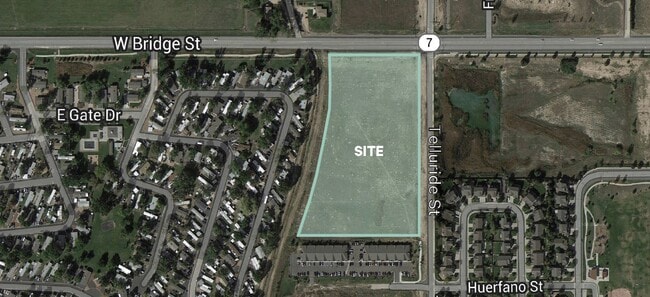
3360 E Bridge St, Brighton, CO 80601


This Property Is For Sale
Property Detail
3360 E Bridge St
Denver-Aurora-Centennial, CO
SECT,TWN,RNG:9-1-66 DESC: BEG 50 FT S OF NE COR NW4 SEC 9 TH W 60 FT TO TRUE POB TH S 835/91 FT TH W 635/43 FT TO PT ON C/L BRIGHTON LATERAL DT TH ALG SD C/L N 17D 51M E 286/95 FT N 14D 21M E 279/61 FT TO BEG OF CURVE TO LEFT HAV RAD OF 432/88 FT THE
1569-09-2-00-001
ADAMS
Commercialacreage
Colorado
B and X Area of moderate flood hazard, usually the area between the limits of the 100-year and 500-year floods.
9.99 AC
2024
Northeast Denver
2025
Denver
008565
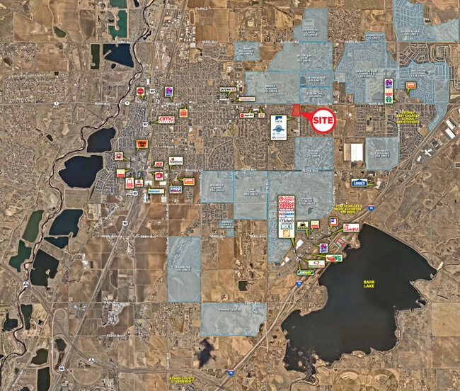
NEARBY LISTINGS FOR SALE OR LEASE
DEMOGRAPHICS near 3360 E Bridge St
1 mile
3 mile
5 mile
2025 Total Population
11,441
48,327
61,623
2030 Population
12,013
51,428
65,713
Pop Growth 2025-2030
+ 5.00%
+ 6.42%
+ 6.64%
Average Age
38
37
37
2025 Total Households
3,829
16,081
20,362
HH Growth 2025-2030
+ 5.33%
+ 6.67%
+ 6.89%
Median Household Inc
$99,307
$107,903
$107,927
Avg Household Size
2.90
2.90
3.00
2025 Avg HH Vehicles
2.00
2.00
2.00
Median Home Value
$497,433
$523,875
$517,287
Median Year Built
2001
2003
2003
Nearby Places
Map Layers
Map Styles
 Street
 Aerial
Transit
 Traffic
 Biking
Places
Listings with unknown addresses are not visible on the map
- Restaurants
- Banks
- Shops
- Fitness
- Groceries
PUBLIC TRANSPORTATION
AIRPORT
Denver International
Drive
Walk
Distance
Denver International
27 min
18.2 mi
Freight Ports
Tulsa Port Of Catoosa
Drive
Walk
Distance
Tulsa Port Of Catoosa
733 min
712.3 mi
Nearby Properties
Address
Land Use
TOTAL SIZE
Lot Size
Zoning
Address
Land Use
TOTAL SIZE
Lot Size
Zoning
374,830 SF
49.94 AC
Address
Land Use
TOTAL SIZE
Lot Size
Zoning
566,409 SF
1.66 AC
Address
Land Use
TOTAL SIZE
Lot Size
Zoning
413,138 SF
20.74 AC
Address
Land Use
TOTAL SIZE
Lot Size
Zoning
275,217 SF
27.30 AC
Address
Land Use
TOTAL SIZE
Lot Size
Zoning
113,764 SF
4.24 AC
Address
Land Use
TOTAL SIZE
Lot Size
Zoning
119,714 SF
4.93 AC
Address
Land Use
TOTAL SIZE
Lot Size
Zoning
116,223 SF
7.38 AC
Address
Land Use
TOTAL SIZE
Lot Size
Zoning
614,010 SF
41.81 AC
Address
Land Use
TOTAL SIZE
Lot Size
Zoning
546,000 SF
35.70 AC
Address
Land Use
TOTAL SIZE
Lot Size
Zoning
71,673 SF
7.59 AC
Address
Land Use
TOTAL SIZE
Lot Size
Zoning
1,305,700 SF
103.31 AC
A3
Address
Land Use
TOTAL SIZE
Lot Size
Zoning
243,589 SF
16.71 AC
Address
Land Use
TOTAL SIZE
Lot Size
Zoning
11,840 SF
6 AC
Address
Land Use
TOTAL SIZE
Lot Size
Zoning
198,433 SF
40.09 AC
Address
Land Use
TOTAL SIZE
Lot Size
Zoning
161,096 SF
82.69 AC
Address
Land Use
TOTAL SIZE
Lot Size
Zoning
59,923 SF
1.83 AC
Address
Land Use
TOTAL SIZE
Lot Size
Zoning
300,300 SF
16.38 AC
Address
Land Use
TOTAL SIZE
Lot Size
Zoning
266,280 SF
12.68 AC
Address
Land Use
TOTAL SIZE
Lot Size
Zoning
223,459 SF
27.46 AC
Address
Land Use
TOTAL SIZE
Lot Size
Zoning
123,627 SF
11.22 AC
Address
Land Use
TOTAL SIZE
Lot Size
Zoning
289,524 SF
15 AC
Address
Land Use
TOTAL SIZE
Lot Size
Zoning
281,164 SF
15.57 AC
Address
Land Use
TOTAL SIZE
Lot Size
Zoning
109,032 SF
13.88 AC
Address
Land Use
TOTAL SIZE
Lot Size
Zoning
61,700 SF
10 AC
Address
Land Use
TOTAL SIZE
Lot Size
Zoning
91,534 SF
23.03 AC
Address
Land Use
TOTAL SIZE
Lot Size
Zoning
85,398 SF
15 AC
Address
Land Use
TOTAL SIZE
Lot Size
Zoning
182,210 SF
17.01 AC
Address
Land Use
TOTAL SIZE
Lot Size
Zoning
256,102 SF
6.66 AC
Address
Land Use
TOTAL SIZE
Lot Size
Zoning
174,724 SF
14.75 AC
Address
Land Use
TOTAL SIZE
Lot Size
Zoning
69,919 SF
6.73 AC
The World's #1 Commercial Real Estate Marketplace
Connect with us
© 2026 CoStar Group
The information above has been obtained from sources believed reliable. While we do not doubt its accuracy we have not verified it and make no guarantee, warranty or representation about it. It is your responsibility to independently confirm its accuracy and completeness. Any projections, opinions, assumptions, or estimates used are for example only and do not represent the current or future performance of the property. The value of this transaction to you depends on tax and other factors which should be evaluated by your tax, financial, and legal advisors. You and your advisors should conduct a careful, independent investigation of the property to determine to your satisfaction the suitability of the property for your needs.