Property Record
3363 E Commerce St, San Antonio, TX 78220
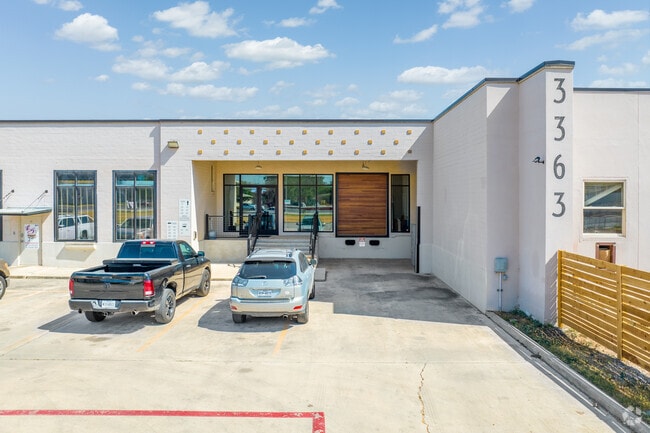

This Property Is For Sale
Property Detail
3363 E Commerce St
10234-000-0072
NCB 10234 BLDG 3(IMPVT ACCT) 2020-CREATED PER CR#48732
Warehouse
BEXAR
B and X Area of moderate flood hazard, usually the area between the limits of the 100-year and 500-year floods.
Texas
2024
71
2025
Northeast
130800
San Antonio
6,720 SF
San Antonio-New Braunfels, TX
NEARBY LISTINGS FOR SALE OR LEASE
DEMOGRAPHICS near 3363 E Commerce St
1 mile
3 mile
5 mile
2025 Total Population
10,092
96,929
272,402
2030 Population
10,854
103,486
289,481
Pop Growth 2025-2030
+ 7.55%
+ 6.76%
+ 6.27%
Average Age
36
36
38
2025 Total Households
3,369
34,201
101,282
HH Growth 2025-2030
+ 7.75%
+ 6.95%
+ 6.60%
Median Household Inc
$33,238
$46,046
$53,293
Avg Household Size
2.80
2.60
2.50
2025 Avg HH Vehicles
2.00
2.00
2.00
Median Home Value
$105,824
$177,680
$214,350
Median Year Built
1964
1964
1967
Nearby Places
Map Layers
Map Styles
 Street
 Aerial
Layers
 Traffic
 Biking
Places
Listings with unknown addresses are not visible on the map
- Restaurants
- Banks
- Shops
- Fitness
- Groceries
PUBLIC TRANSPORTATION
COMMUTER RAIL
San Antonio Amtrak Station (Sunset Limited - Amtrak, Texas Eagle - Amtrak)
Drive
Walk
Distance
San Antonio Amtrak Station (Sunset Limited - Amtrak, Texas Eagle - Amtrak)
6 min
2.9 mi
AIRPORT
San Antonio International
Drive
Walk
Distance
San Antonio International
16 min
10.8 mi
Freight Ports
Calhoun Port
Drive
Walk
Distance
Calhoun Port
176 min
143.9 mi
Nearby Properties
Address
Land Use
TOTAL SIZE
Lot Size
Zoning
Address
Land Use
TOTAL SIZE
Lot Size
Zoning
2,544.56 AC
Address
Land Use
TOTAL SIZE
Lot Size
Zoning
738,650 SF
2.93 AC
Address
Land Use
TOTAL SIZE
Lot Size
Zoning
1,049,861 SF
1.50 AC
Address
Land Use
TOTAL SIZE
Lot Size
Zoning
339,590 SF
3.12 AC
Address
Land Use
TOTAL SIZE
Lot Size
Zoning
11,915 SF
4.06 AC
Address
Land Use
TOTAL SIZE
Lot Size
Zoning
221,865 SF
3.12 AC
Address
Land Use
TOTAL SIZE
Lot Size
Zoning
303,199 SF
9.88 AC
Address
Land Use
TOTAL SIZE
Lot Size
Zoning
161,652 SF
1.79 AC
Address
Land Use
TOTAL SIZE
Lot Size
Zoning
9,390 SF
3.71 AC
Address
Land Use
TOTAL SIZE
Lot Size
Zoning
397,806 SF
15.08 AC
Address
Land Use
TOTAL SIZE
Lot Size
Zoning
352,920 SF
2.48 AC
Address
Land Use
TOTAL SIZE
Lot Size
Zoning
331,500 SF
1.82 AC
Address
Land Use
TOTAL SIZE
Lot Size
Zoning
359,459 SF
15.81 AC
Address
Land Use
TOTAL SIZE
Lot Size
Zoning
202,609 SF
3.25 AC
Address
Land Use
TOTAL SIZE
Lot Size
Zoning
71,253 SF
25.52 AC
Address
Land Use
TOTAL SIZE
Lot Size
Zoning
147,381 SF
0.92 AC
Address
Land Use
TOTAL SIZE
Lot Size
Zoning
35.76 AC
Address
Land Use
TOTAL SIZE
Lot Size
Zoning
117,725 SF
3.12 AC
Address
Land Use
TOTAL SIZE
Lot Size
Zoning
384,828 SF
3.18 AC
Address
Land Use
TOTAL SIZE
Lot Size
Zoning
139,410 SF
35.75 AC
Address
Land Use
TOTAL SIZE
Lot Size
Zoning
187,369 SF
5.69 AC
Address
Land Use
TOTAL SIZE
Lot Size
Zoning
4,623 SF
1.27 AC
Address
Land Use
TOTAL SIZE
Lot Size
Zoning
3,458 SF
2.03 AC
Address
Land Use
TOTAL SIZE
Lot Size
Zoning
3,040 SF
12.58 AC
Address
Land Use
TOTAL SIZE
Lot Size
Zoning
110,252 SF
20.04 AC
Address
Land Use
TOTAL SIZE
Lot Size
Zoning
79,458 SF
1.30 AC
Address
Land Use
TOTAL SIZE
Lot Size
Zoning
58,232 SF
2.54 AC
Address
Land Use
TOTAL SIZE
Lot Size
Zoning
300,987 SF
29.07 AC
Address
Land Use
TOTAL SIZE
Lot Size
Zoning
33.77 AC
Address
Land Use
TOTAL SIZE
Lot Size
Zoning
19,872 SF
6.92 AC
The World's #1 Commercial Real Estate Marketplace
Connect with us
© 2026 CoStar Group
The information above has been obtained from sources believed reliable. While we do not doubt its accuracy we have not verified it and make no guarantee, warranty or representation about it. It is your responsibility to independently confirm its accuracy and completeness. Any projections, opinions, assumptions, or estimates used are for example only and do not represent the current or future performance of the property. The value of this transaction to you depends on tax and other factors which should be evaluated by your tax, financial, and legal advisors. You and your advisors should conduct a careful, independent investigation of the property to determine to your satisfaction the suitability of the property for your needs.