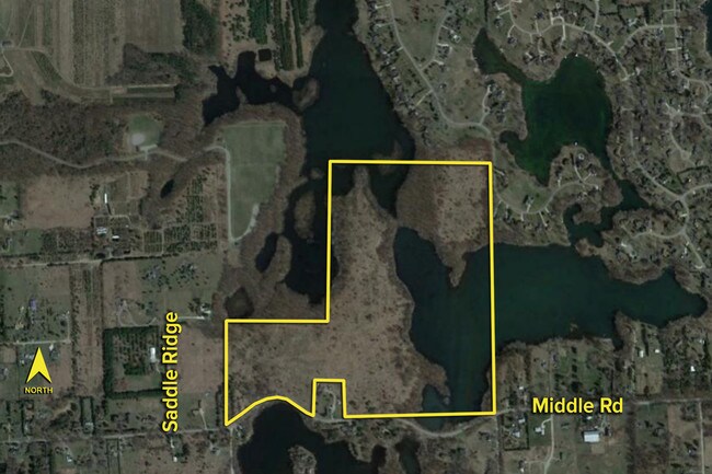
Property Record
3364 Mantua Farms, Highland, MI 48357


NEARBY LISTINGS FOR SALE OR LEASE
Property Detail
3364 Mantua Farms
11-08-400-004
T3N, R7E, SEC 8 PART OF SE 1/4 BEG AT SE SEC COR, TH S 89-20-10 W 1576.30 FT, TH N 00-39-50 W 360.00 FT, TH S 89-20-10 W 250
Residentialacreage
Oakland
A
Michigan
26093C0250D
122.05 AC
2023
St Clair & Lapeer Counties
2023
Detroit
131800
Detroit-Warren-Dearborn, MI
DEMOGRAPHICS near 3364 Mantua Farms
1 Mile
3 Mile
5 Mile
2024 Total Population
1,279
14,235
34,545
2029 Population
1,265
14,348
34,734
Pop Growth 2024-2029
(1.09%)
+ 0.79%
+ 0.55%
Average Age
46
43
43
2024 Total Households
474
5,376
13,124
HH Growth 2024-2029
(1.27%)
+ 0.69%
+ 0.49%
Median Household Inc
$102,286
$94,456
$93,166
Avg Household Size
2.60
2.60
2.60
2024 Avg HH Vehicles
2.00
2.00
2.00
Median Home Value
$337,362
$320,080
$324,060
Median Year Built
1978
1982
1983
Nearby Places
Map Layers
Map Styles
 Street
 Aerial
- Restaurants
- Banks
- Shops
- Fitness
- Groceries
PUBLIC TRANSPORTATION
AIRPORT
Bishop International
DRIVE
WALK
Distance
Bishop International
53 min
27.4 mi
Freight Ports
Port of Toledo
DRIVE
WALK
Distance
Port of Toledo
116 min
88.6 mi
SALE & LEASE HISTORY
LISTING DATE
SALE/LEASE

Sep 24, 2016
For Sale
Nearby Properties
Address
Land Use
TOTAL SIZE
Lot Size
Zoning
Address
Land Use
TOTAL SIZE
Lot Size
Zoning
6,498 SF
77.52 AC
MM
Address
Land Use
TOTAL SIZE
Lot Size
Zoning
83,159 SF
34.44 AC
Address
Land Use
TOTAL SIZE
Lot Size
Zoning
26,054 SF
7.90 AC
AV
Address
Land Use
TOTAL SIZE
Lot Size
Zoning
34,075 SF
14.06 AC
BI
Address
Land Use
TOTAL SIZE
Lot Size
Zoning
38,846 SF
6.78 AC
BI
Address
Land Use
TOTAL SIZE
Lot Size
Zoning
51,167 SF
11.08 AC
BI
Address
Land Use
TOTAL SIZE
Lot Size
Zoning
55,183 SF
Address
Land Use
TOTAL SIZE
Lot Size
Zoning
47,204 SF
10.77 AC
II
Address
Land Use
TOTAL SIZE
Lot Size
Zoning
24,370 SF
4.86 AC
BI
Address
Land Use
TOTAL SIZE
Lot Size
Zoning
4,870 SF
399.43 AC
RV
Address
Land Use
TOTAL SIZE
Lot Size
Zoning
27,756 SF
228.31 AC
Address
Land Use
TOTAL SIZE
Lot Size
Zoning
34,464 SF
7.45 AC
AI
Address
Land Use
TOTAL SIZE
Lot Size
Zoning
47,996 SF
8.99 AC
BI
Address
Land Use
TOTAL SIZE
Lot Size
Zoning
36,928 SF
5.16 AC
II
Address
Land Use
TOTAL SIZE
Lot Size
Zoning
58,721 SF
7.59 AC
BI
Address
Land Use
TOTAL SIZE
Lot Size
Zoning
68,340 SF
5.48 AC
II
Address
Land Use
TOTAL SIZE
Lot Size
Zoning
21,000 SF
3.12 AC
BI
Address
Land Use
TOTAL SIZE
Lot Size
Zoning
59,200 SF
6 AC
II
Address
Land Use
TOTAL SIZE
Lot Size
Zoning
37,646 SF
7.53 AC
SI
Address
Land Use
TOTAL SIZE
Lot Size
Zoning
15,105 SF
140 AC
CA
Address
Land Use
TOTAL SIZE
Lot Size
Zoning
50.93 AC
MM
Address
Land Use
TOTAL SIZE
Lot Size
Zoning
32,400 SF
2.67 AC
II
Address
Land Use
TOTAL SIZE
Lot Size
Zoning
38,449 SF
2.60 AC
IV
Address
Land Use
TOTAL SIZE
Lot Size
Zoning
44,893 SF
22.58 AC
MM
Address
Land Use
TOTAL SIZE
Lot Size
Zoning
20,700 SF
Address
Land Use
TOTAL SIZE
Lot Size
Zoning
12,600 SF
1.58 AC
BV
Address
Land Use
TOTAL SIZE
Lot Size
Zoning
17,820 SF
4.71 AC
BI
Address
Land Use
TOTAL SIZE
Lot Size
Zoning
40,700 SF
8.19 AC
II
Address
Land Use
TOTAL SIZE
Lot Size
Zoning
24,925 SF
5.30 AC
II
Address
Land Use
TOTAL SIZE
Lot Size
Zoning
3,865 SF
2.57 AC
BI
The World's #1 Commercial Real Estate Marketplace
Connect with us
© 2026 CoStar Group
The information above has been obtained from sources believed reliable. While we do not doubt its accuracy we have not verified it and make no guarantee, warranty or representation about it. It is your responsibility to independently confirm its accuracy and completeness. Any projections, opinions, assumptions, or estimates used are for example only and do not represent the current or future performance of the property. The value of this transaction to you depends on tax and other factors which should be evaluated by your tax, financial, and legal advisors. You and your advisors should conduct a careful, independent investigation of the property to determine to your satisfaction the suitability of the property for your needs.