Property Record
3367 N Carl G Rose Hwy, Hernando, FL 34442
NEARBY LISTINGS FOR SALE OR LEASE
-
-
View all Hernando listings for sale on LoopNet.com
Property Detail
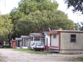
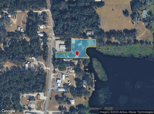
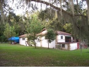
3367 N Carl G Rose Hwy
Homosassa Springs, FL
Sanders Heights Amended
19E-18S-23-0030-00000-0036
B H SANDERS ADD TO HERNANDO PB 1 PG 28 PT OF LOT 3 E OF SR 200 LESS N 50 FT FOR R/W & PT OF N 47.5 FT OF LOT 5 E OF SR 200 & BEG AT SE COR OF LT 1 TH W AL S LN OF LT 1 A DIST OF 85 FT TO NE COR OF LT 3 TH S 0 DEG 3M E AL E LN OF LT 3 A DIST OF 247.5
Multifamilydwelling
Citrus
AE
Florida
12017C0236D
3
2024
1.80 AC
2025
Florida Central North Area
450105
Other Market Areas
5,549 SF
DEMOGRAPHICS near 3367 N Carl G Rose Hwy
1 Mile
3 Mile
5 Mile
2024 Total Population
1,616
11,580
35,641
2029 Population
1,864
13,205
40,625
Pop Growth 2024-2029
+ 15.35%
+ 14.03%
+ 13.98%
Average Age
56
51
52
2024 Total Households
798
5,293
16,368
HH Growth 2024-2029
+ 15.04%
+ 13.83%
+ 13.80%
Median Household Inc
$48,030
$46,340
$45,552
Avg Household Size
1.90
2.10
2.10
2024 Avg HH Vehicles
2.00
2.00
2.00
Median Home Value
$191,421
$189,679
$200,439
Median Year Built
1989
1991
1989
Nearby Places
- Restaurants
- Banks
- Shops
- Fitness
- Groceries
Nearby Properties
Address
Land Use
TOTAL SIZE
Lot Size
Zoning
Address
Land Use
TOTAL SIZE
Lot Size
Zoning
84,611 SF
33.22 AC
PSI
Address
Land Use
TOTAL SIZE
Lot Size
Zoning
119,399 SF
4.77 AC
GNC
Address
Land Use
TOTAL SIZE
Lot Size
Zoning
74,320 SF
4.51 AC
GNC
Address
Land Use
TOTAL SIZE
Lot Size
Zoning
40,648 SF
4.85 AC
GNC
Address
Land Use
TOTAL SIZE
Lot Size
Zoning
18,114 SF
9.11 AC
GNC
Address
Land Use
TOTAL SIZE
Lot Size
Zoning
728 SF
14.64 AC
MHP
Address
Land Use
TOTAL SIZE
Lot Size
Zoning
24,600 SF
1.64 AC
LDR
Address
Land Use
TOTAL SIZE
Lot Size
Zoning
46,900 SF
2.04 AC
GNC
Address
Land Use
TOTAL SIZE
Lot Size
Zoning
42,640 SF
5.04 AC
GNC
Address
Land Use
TOTAL SIZE
Lot Size
Zoning
27,692 SF
4.05 AC
PSI
Address
Land Use
TOTAL SIZE
Lot Size
Zoning
17,008 SF
5.07 AC
LDRMH
Address
Land Use
TOTAL SIZE
Lot Size
Zoning
28,222 SF
15.81 AC
LDRMH
Address
Land Use
TOTAL SIZE
Lot Size
Zoning
28,078 SF
3.48 AC
GNC
Address
Land Use
TOTAL SIZE
Lot Size
Zoning
3,914 SF
5.02 AC
CLR
Address
Land Use
TOTAL SIZE
Lot Size
Zoning
31,200 SF
3.58 AC
GNC
Address
Land Use
TOTAL SIZE
Lot Size
Zoning
8,650 SF
3.55 AC
GNC
Address
Land Use
TOTAL SIZE
Lot Size
Zoning
28,006 SF
2.05 AC
GNC
Address
Land Use
TOTAL SIZE
Lot Size
Zoning
24.12 AC
RVP
Address
Land Use
TOTAL SIZE
Lot Size
Zoning
29,130 SF
3.27 AC
GNC
Address
Land Use
TOTAL SIZE
Lot Size
Zoning
11,384 SF
6.96 AC
GNC
Address
Land Use
TOTAL SIZE
Lot Size
Zoning
9,100 SF
2.21 AC
GNC
Address
Land Use
TOTAL SIZE
Lot Size
Zoning
11,812 SF
1.06 AC
GNC
Address
Land Use
TOTAL SIZE
Lot Size
Zoning
8,574 SF
1.13 AC
MDRMH
Address
Land Use
TOTAL SIZE
Lot Size
Zoning
9,230 SF
1.52 AC
PDR
Address
Land Use
TOTAL SIZE
Lot Size
Zoning
1,200 SF
43.89 AC
PSI
Address
Land Use
TOTAL SIZE
Lot Size
Zoning
10,162 SF
137.04 AC
CL
Address
Land Use
TOTAL SIZE
Lot Size
Zoning
9,780 SF
11.86 AC
CL
Address
Land Use
TOTAL SIZE
Lot Size
Zoning
17,664 SF
2.02 AC
GNC
Address
Land Use
TOTAL SIZE
Lot Size
Zoning
20,038 SF
4.78 AC
CLR
Address
Land Use
TOTAL SIZE
Lot Size
Zoning
18,666 SF
1.87 AC
GNC
The World's #1 Commercial Real Estate Marketplace
Connect with us
© 2025 CoStar Group
The information above has been obtained from sources believed reliable. While we do not doubt its accuracy we have not verified it and make no guarantee, warranty or representation about it. It is your responsibility to independently confirm its accuracy and completeness. Any projections, opinions, assumptions, or estimates used are for example only and do not represent the current or future performance of the property. The value of this transaction to you depends on tax and other factors which should be evaluated by your tax, financial, and legal advisors. You and your advisors should conduct a careful, independent investigation of the property to determine to your satisfaction the suitability of the property for your needs.