Property Record
3368 Route 9, Saratoga Springs, NY 12866


NEARBY LISTINGS FOR SALE OR LEASE
-
-
View all Saratoga Springs listings for sale on LoopNet.com
Property Detail
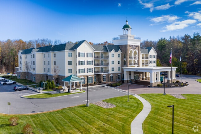
3368 Route 9
Albany-Schenectady-Troy, NY
S-08 B-J L-6B OUTSIDE
411589 178.-2-16
Saratoga
Hotel
New York
2024
16.000
2024
5.17 AC
061301
Latham/Saratoga Springs
105,772 SF
Albany/Schenectady/Troy
DEMOGRAPHICS near 3368 Route 9
1 Mile
3 Mile
5 Mile
2024 Total Population
1,693
26,736
56,196
2029 Population
1,810
28,084
58,949
Pop Growth 2024-2029
+ 6.91%
+ 5.04%
+ 4.90%
Average Age
45
45
44
2024 Total Households
796
12,925
25,533
HH Growth 2024-2029
+ 6.91%
+ 5.15%
+ 5.00%
Median Household Inc
$74,895
$85,884
$90,842
Avg Household Size
2.00
2.00
2.10
2024 Avg HH Vehicles
2.00
2.00
2.00
Median Home Value
$408,511
$405,215
$356,932
Median Year Built
1992
1974
1984
Nearby Places
Map Layers
Map Styles
 Street
 Aerial
- Restaurants
- Banks
- Shops
- Fitness
- Groceries
PUBLIC TRANSPORTATION
COMMUTER RAIL
Saratoga Springs Amtrak Station (Adirondack - Amtrak, Ethan Allen Express - Amtrak)
DRIVE
WALK
Distance
Saratoga Springs Amtrak Station (Adirondack - Amtrak, Ethan Allen Express - Amtrak)
7 min
3.3 mi
AIRPORT
Albany International
DRIVE
WALK
Distance
Albany International
31 min
23.4 mi
Freight Ports
Albany, NY Port
DRIVE
WALK
Distance
Albany, NY Port
46 min
33.9 mi
Nearby Properties
Address
Land Use
TOTAL SIZE
Lot Size
Zoning
Address
Land Use
TOTAL SIZE
Lot Size
Zoning
249,750 SF
10.47 AC
C4
Address
Land Use
TOTAL SIZE
Lot Size
Zoning
214,000 SF
127.30 AC
INSHT
Address
Land Use
TOTAL SIZE
Lot Size
Zoning
246,647 SF
160.43 AC
INSHT
Address
Land Use
TOTAL SIZE
Lot Size
Zoning
507,600 SF
55.01 AC
INSED
Address
Land Use
TOTAL SIZE
Lot Size
Zoning
173,482 SF
5.27 AC
C1
Address
Land Use
TOTAL SIZE
Lot Size
Zoning
76,938 SF
10.53 AC
PUD
Address
Land Use
TOTAL SIZE
Lot Size
Zoning
78,848 SF
6.54 AC
PUD
Address
Land Use
TOTAL SIZE
Lot Size
Zoning
113,052 SF
2.86 AC
UR5
Address
Land Use
TOTAL SIZE
Lot Size
Zoning
4,400 SF
13.96 AC
UR4
Address
Land Use
TOTAL SIZE
Lot Size
Zoning
2,160 SF
14.67 AC
R1
Address
Land Use
TOTAL SIZE
Lot Size
Zoning
28,437 SF
61.38 AC
INSPR
Address
Land Use
TOTAL SIZE
Lot Size
Zoning
905,719 SF
62.10 AC
INDG
Address
Land Use
TOTAL SIZE
Lot Size
Zoning
39,632 SF
19.11 AC
C7
Address
Land Use
TOTAL SIZE
Lot Size
Zoning
4,740 SF
37.10 AC
C7
Address
Land Use
TOTAL SIZE
Lot Size
Zoning
5,152 SF
30.20 AC
UR1
Address
Land Use
TOTAL SIZE
Lot Size
Zoning
2,700 SF
162.85 AC
C1
Address
Land Use
TOTAL SIZE
Lot Size
Zoning
139,794 SF
21.32 AC
C2
Address
Land Use
TOTAL SIZE
Lot Size
Zoning
102,147 SF
3.07 AC
C3
Address
Land Use
TOTAL SIZE
Lot Size
Zoning
47,740 SF
6.02 AC
PUD
Address
Land Use
TOTAL SIZE
Lot Size
Zoning
186,791 SF
3.67 AC
C1
Address
Land Use
TOTAL SIZE
Lot Size
Zoning
28,068 SF
2.20 AC
C5
Address
Land Use
TOTAL SIZE
Lot Size
Zoning
28,068 SF
2.20 AC
C5
Address
Land Use
TOTAL SIZE
Lot Size
Zoning
100,453 SF
2.85 AC
C5
Address
Land Use
TOTAL SIZE
Lot Size
Zoning
171,370 SF
2.31 AC
UR7
Address
Land Use
TOTAL SIZE
Lot Size
Zoning
111,657 SF
1.05 AC
C1
Address
Land Use
TOTAL SIZE
Lot Size
Zoning
131,256 SF
16.70 AC
INSED
Address
Land Use
TOTAL SIZE
Lot Size
Zoning
361,330 SF
25.15 AC
INDG
Address
Land Use
TOTAL SIZE
Lot Size
Zoning
93,652 SF
3.64 AC
C4A
Address
Land Use
TOTAL SIZE
Lot Size
Zoning
81,122 SF
6.21 AC
Address
Land Use
TOTAL SIZE
Lot Size
Zoning
218,344 SF
2.62 AC
C1
The World's #1 Commercial Real Estate Marketplace
Connect with us
© 2026 CoStar Group
The information above has been obtained from sources believed reliable. While we do not doubt its accuracy we have not verified it and make no guarantee, warranty or representation about it. It is your responsibility to independently confirm its accuracy and completeness. Any projections, opinions, assumptions, or estimates used are for example only and do not represent the current or future performance of the property. The value of this transaction to you depends on tax and other factors which should be evaluated by your tax, financial, and legal advisors. You and your advisors should conduct a careful, independent investigation of the property to determine to your satisfaction the suitability of the property for your needs.