Property Record
337 E 5Th St, Plainfield, NJ 07060
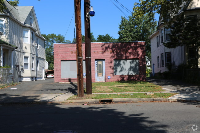

Property Detail
337 E 5Th St
12-00606-0000-00041
ADDITIONAL LOTS: 1450 SQ FT
Commercialnec
Union
MU
New Jersey
AO River or stream flood hazard areas, and areas with a 1% or greater chance of shallow flooding each year. These areas have a 26% chance of flooding over the life of a 30-year mortgage.
41
2024
0.13 AC
2025
Route 78/22 East
039000
Northern New Jersey
1,450 SF
Newark, NJ
NEARBY LISTINGS FOR SALE OR LEASE
DEMOGRAPHICS near 337 E 5Th St
1 mile
3 mile
5 mile
2024 Total Population
36,182
136,794
298,861
2029 Population
37,460
142,506
313,173
Pop Growth 2024-2029
+ 3.53%
+ 4.18%
+ 4.79%
Average Age
36
39
40
2024 Total Households
10,858
43,964
99,899
HH Growth 2024-2029
+ 3.66%
+ 4.33%
+ 4.95%
Median Household Inc
$77,408
$109,200
$129,030
Avg Household Size
3.20
3.00
2.90
2024 Avg HH Vehicles
1.00
2.00
2.00
Median Home Value
$418,973
$480,361
$618,093
Median Year Built
1948
1956
1962
Nearby Places
Map Layers
Map Styles
 Street
 Aerial
Transit
 Traffic
 Biking
Places
Listings with unknown addresses are not visible on the map
- Restaurants
- Banks
- Shops
- Fitness
- Groceries
PUBLIC TRANSPORTATION
COMMUTER RAIL
Plainfield (Raritan Valley Line - NJ Transit Commuter Rail (NJ Transit))
Drive
Walk
Distance
Plainfield (Raritan Valley Line - NJ Transit Commuter Rail (NJ Transit))
1 min
7 min
0.4 mi
Netherwood (Raritan Valley Line - NJ Transit Commuter Rail (NJ Transit))
Drive
Walk
Distance
Netherwood (Raritan Valley Line - NJ Transit Commuter Rail (NJ Transit))
2 min
16 min
0.9 mi
AIRPORT
Newark Liberty International
Drive
Walk
Distance
Newark Liberty International
30 min
20.4 mi
Freight Ports
New York Container Terminal
Drive
Walk
Distance
New York Container Terminal
33 min
17.8 mi
SALE & LEASE HISTORY
LISTING DATE
SALE/LEASE

Mar 14, 2019
For Sale
Jun 02, 2021
For Sale
Feb 01, 2020
For Lease
Nearby Properties
Address
Land Use
TOTAL SIZE
Lot Size
Zoning
Address
Land Use
TOTAL SIZE
Lot Size
Zoning
20.08 AC
RML1
Address
Land Use
TOTAL SIZE
Lot Size
Zoning
26.87 AC
H-D
Address
Land Use
TOTAL SIZE
Lot Size
Zoning
27.70 AC
Address
Land Use
TOTAL SIZE
Lot Size
Zoning
47.69 AC
MU
Address
Land Use
TOTAL SIZE
Lot Size
Zoning
47.80 AC
H-D
Address
Land Use
TOTAL SIZE
Lot Size
Zoning
15.79 AC
H-D
Address
Land Use
TOTAL SIZE
Lot Size
Zoning
12.47 AC
H-D
Address
Land Use
TOTAL SIZE
Lot Size
Zoning
19.84 AC
Address
Land Use
TOTAL SIZE
Lot Size
Zoning
16.97 AC
Address
Land Use
TOTAL SIZE
Lot Size
Zoning
30.80 AC
R10
Address
Land Use
TOTAL SIZE
Lot Size
Zoning
4.74 AC
NC
Address
Land Use
TOTAL SIZE
Lot Size
Zoning
19.84 AC
H-D
Address
Land Use
TOTAL SIZE
Lot Size
Zoning
30.40 AC
PR
Address
Land Use
TOTAL SIZE
Lot Size
Zoning
19.19 AC
R-3
Address
Land Use
TOTAL SIZE
Lot Size
Zoning
21.53 AC
H-D
Address
Land Use
TOTAL SIZE
Lot Size
Zoning
122,820 SF
14.65 AC
H-D
Address
Land Use
TOTAL SIZE
Lot Size
Zoning
12.52 AC
H-D
Address
Land Use
TOTAL SIZE
Lot Size
Zoning
21.60 AC
M3
Address
Land Use
TOTAL SIZE
Lot Size
Zoning
11.20 AC
Address
Land Use
TOTAL SIZE
Lot Size
Zoning
0.39 AC
R5
Address
Land Use
TOTAL SIZE
Lot Size
Zoning
11.02 AC
Address
Land Use
TOTAL SIZE
Lot Size
Zoning
12.06 AC
Address
Land Use
TOTAL SIZE
Lot Size
Zoning
6.76 AC
MU
Address
Land Use
TOTAL SIZE
Lot Size
Zoning
Address
Land Use
TOTAL SIZE
Lot Size
Zoning
87,778 SF
1.88 AC
Address
Land Use
TOTAL SIZE
Lot Size
Zoning
Address
Land Use
TOTAL SIZE
Lot Size
Zoning
43.03 AC
R-1
Address
Land Use
TOTAL SIZE
Lot Size
Zoning
4,900 SF
Address
Land Use
TOTAL SIZE
Lot Size
Zoning
39,840 SF
10.97 AC
LI1
Address
Land Use
TOTAL SIZE
Lot Size
Zoning
3.68 AC
R-7
The World's #1 Commercial Real Estate Marketplace
Connect with us
© 2026 CoStar Group
The information above has been obtained from sources believed reliable. While we do not doubt its accuracy we have not verified it and make no guarantee, warranty or representation about it. It is your responsibility to independently confirm its accuracy and completeness. Any projections, opinions, assumptions, or estimates used are for example only and do not represent the current or future performance of the property. The value of this transaction to you depends on tax and other factors which should be evaluated by your tax, financial, and legal advisors. You and your advisors should conduct a careful, independent investigation of the property to determine to your satisfaction the suitability of the property for your needs.