Property Record
337 Longley Dr, Port Charlotte, FL 33954

This Property Is For Sale
NEARBY LISTINGS FOR SALE OR LEASE
Property Detail
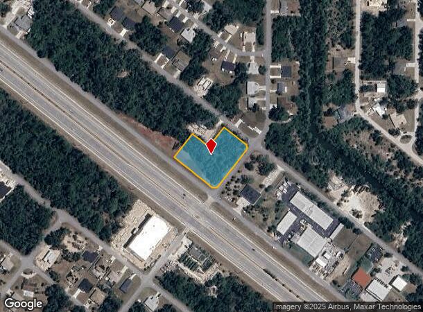
337 Longley Dr
Punta Gorda, FL
Port Charlotte
402103427036
PORT CHARLOTTE SEC32 REP BLK2420 LTS 53 & 54 159/99 566/2141 1964/108 2266/1577 2291/1999 2959/871 3269519 3362817 3403591 PCH 032 2420 0002 PORT CHARLOTTE SEC32 BLK2420 LT 2 208/164 660/187 L/E1335/744 DC1510/108-AAK 3012/1971
Commercialacreage
Charlotte
X
Florida
12015C0040G
53,54
2024
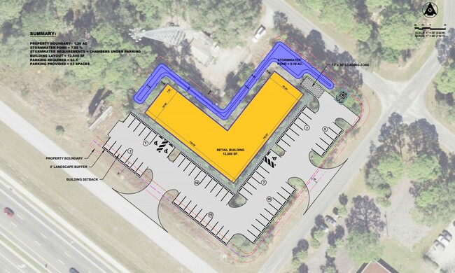
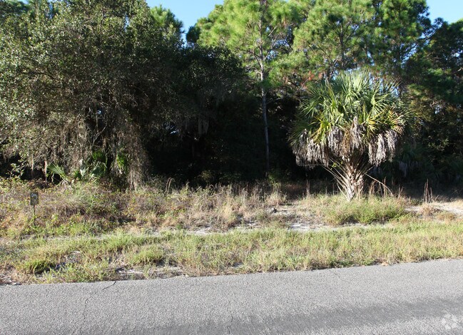
1.37 AC
2025
Charlotte County
020206
Southwest Florida
DEMOGRAPHICS near 337 Longley Dr
1 Mile
3 Mile
5 Mile
2024 Total Population
2,572
28,631
89,139
2029 Population
3,046
33,208
103,629
Pop Growth 2024-2029
+ 18.43%
+ 15.99%
+ 16.26%
Average Age
45
47
47
2024 Total Households
1,017
11,702
36,934
HH Growth 2024-2029
+ 18.68%
+ 16.09%
+ 16.46%
Median Household Inc
$54,263
$58,344
$62,586
Avg Household Size
2.40
2.40
2.40
2024 Avg HH Vehicles
2.00
2.00
2.00
Median Home Value
$264,189
$245,935
$241,759
Median Year Built
1999
2001
1998
Nearby Places
- Restaurants
- Banks
- Shops
- Fitness
- Groceries
PUBLIC TRANSPORTATION
AIRPORT
Punta Gorda
DRIVE
WALK
Distance
Punta Gorda
29 min
15.4 mi
Freight Ports
Port Manatee
DRIVE
WALK
Distance
Port Manatee
73 min
56.2 mi
Nearby Properties
Address
Land Use
TOTAL SIZE
Lot Size
Zoning
Address
Land Use
TOTAL SIZE
Lot Size
Zoning
316,994 SF
40.88 AC
V
Address
Land Use
TOTAL SIZE
Lot Size
Zoning
103,886 SF
21.48 AC
PD
Address
Land Use
TOTAL SIZE
Lot Size
Zoning
267,412 SF
23.26 AC
AC1
Address
Land Use
TOTAL SIZE
Lot Size
Zoning
198,132 SF
17.61 AC
RMF15
Address
Land Use
TOTAL SIZE
Lot Size
Zoning
132,969 SF
80.28 AC
PKR
Address
Land Use
TOTAL SIZE
Lot Size
Zoning
261,557 SF
46.25 AC
OMI
Address
Land Use
TOTAL SIZE
Lot Size
Zoning
196,676 SF
30 AC
OMI
Address
Land Use
TOTAL SIZE
Lot Size
Zoning
131,053 SF
14.40 AC
PD
Address
Land Use
TOTAL SIZE
Lot Size
Zoning
583,831 SF
54.32 AC
CG
Address
Land Use
TOTAL SIZE
Lot Size
Zoning
205,624 SF
21.37 AC
AC1
Address
Land Use
TOTAL SIZE
Lot Size
Zoning
9,511 SF
40.53 AC
PD
Address
Land Use
TOTAL SIZE
Lot Size
Zoning
141,619 SF
12.39 AC
II
Address
Land Use
TOTAL SIZE
Lot Size
Zoning
114,985 SF
29.77 AC
GU
Address
Land Use
TOTAL SIZE
Lot Size
Zoning
79,944 SF
15.64 AC
AC1
Address
Land Use
TOTAL SIZE
Lot Size
Zoning
94,423 SF
12.87 AC
V
Address
Land Use
TOTAL SIZE
Lot Size
Zoning
52,706 SF
4.81 AC
V
Address
Land Use
TOTAL SIZE
Lot Size
Zoning
142,364 SF
13.87 AC
AC1
Address
Land Use
TOTAL SIZE
Lot Size
Zoning
95.20 AC
PD
Address
Land Use
TOTAL SIZE
Lot Size
Zoning
37,567 SF
36.76 AC
PKR
Address
Land Use
TOTAL SIZE
Lot Size
Zoning
4,562 SF
8.08 AC
CG
Address
Land Use
TOTAL SIZE
Lot Size
Zoning
85,529 SF
11.41 AC
AC1
Address
Land Use
TOTAL SIZE
Lot Size
Zoning
105,046 SF
12.69 AC
AC1
Address
Land Use
TOTAL SIZE
Lot Size
Zoning
74,447 SF
4.50 AC
CG
Address
Land Use
TOTAL SIZE
Lot Size
Zoning
115,678 SF
8.58 AC
R3
Address
Land Use
TOTAL SIZE
Lot Size
Zoning
135,430 SF
18.50 AC
CG
Address
Land Use
TOTAL SIZE
Lot Size
Zoning
48,392 SF
3.89 AC
PD
Address
Land Use
TOTAL SIZE
Lot Size
Zoning
30,242 SF
7.40 AC
CG
Address
Land Use
TOTAL SIZE
Lot Size
Zoning
63,016 SF
2.56 AC
AC1
Address
Land Use
TOTAL SIZE
Lot Size
Zoning
40,467 SF
2.89 AC
CG
Address
Land Use
TOTAL SIZE
Lot Size
Zoning
22.07 AC
PD
The World's #1 Commercial Real Estate Marketplace
Connect with us
© 2025 CoStar Group
The information above has been obtained from sources believed reliable. While we do not doubt its accuracy we have not verified it and make no guarantee, warranty or representation about it. It is your responsibility to independently confirm its accuracy and completeness. Any projections, opinions, assumptions, or estimates used are for example only and do not represent the current or future performance of the property. The value of this transaction to you depends on tax and other factors which should be evaluated by your tax, financial, and legal advisors. You and your advisors should conduct a careful, independent investigation of the property to determine to your satisfaction the suitability of the property for your needs.