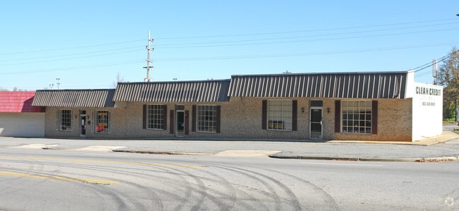
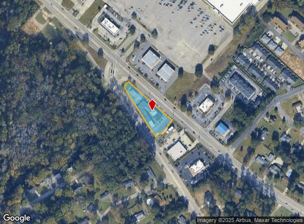
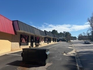
Property Record
178 Highway 178, Orangeburg, SC 29115
NEARBY LISTINGS FOR SALE OR LEASE
Property Detail
178 Highway 178
0151-15-07-001.000
PAPPA JOHN'S, CORBETTS, BP 5100170809
Storebuilding
Orangeburg
X
South Carolina
45075C0169C
0.99 AC
2024
Orangeburg/Sumter
2024
Other Market Areas
011400
Orangeburg, SC
9,072 SF
DEMOGRAPHICS near 178 Highway 178
1 Mile
3 Mile
5 Mile
2024 Total Population
2,662
23,858
35,447
2029 Population
2,559
23,482
34,824
Pop Growth 2024-2029
(3.87%)
(1.58%)
(1.76%)
Average Age
45
39
39
2024 Total Households
1,177
8,854
13,565
HH Growth 2024-2029
(3.74%)
(1.65%)
(1.80%)
Median Household Inc
$67,182
$32,476
$30,691
Avg Household Size
2.20
2.20
2.30
2024 Avg HH Vehicles
2.00
2.00
2.00
Median Home Value
$147,713
$125,150
$106,712
Median Year Built
1972
1976
1978
Nearby Places
- Restaurants
- Banks
- Shops
- Fitness
- Groceries
PUBLIC TRANSPORTATION
AIRPORT
Columbia Metro
DRIVE
WALK
Distance
Columbia Metro
56 min
42.7 mi
SALE & LEASE HISTORY
LISTING DATE
SALE/LEASE

Mar 06, 2025
For Lease
Nearby Properties
Address
Land Use
TOTAL SIZE
Lot Size
Zoning
Address
Land Use
TOTAL SIZE
Lot Size
Zoning
534,738 SF
53.78 AC
Address
Land Use
TOTAL SIZE
Lot Size
Zoning
320,700 SF
35.10 AC
Address
Land Use
TOTAL SIZE
Lot Size
Zoning
195,536 SF
22.90 AC
Address
Land Use
TOTAL SIZE
Lot Size
Zoning
206,224 SF
42.20 AC
Address
Land Use
TOTAL SIZE
Lot Size
Zoning
20,838 SF
7.70 AC
Address
Land Use
TOTAL SIZE
Lot Size
Zoning
130,175 SF
15.59 AC
Address
Land Use
TOTAL SIZE
Lot Size
Zoning
41,412 SF
7.40 AC
Address
Land Use
TOTAL SIZE
Lot Size
Zoning
7,634 SF
0.72 AC
Address
Land Use
TOTAL SIZE
Lot Size
Zoning
29,977 SF
9.57 AC
Address
Land Use
TOTAL SIZE
Lot Size
Zoning
5,059 SF
3.60 AC
Address
Land Use
TOTAL SIZE
Lot Size
Zoning
20,160 SF
3.35 AC
Address
Land Use
TOTAL SIZE
Lot Size
Zoning
1,664 SF
1 AC
Address
Land Use
TOTAL SIZE
Lot Size
Zoning
35,928 SF
1.86 AC
Address
Land Use
TOTAL SIZE
Lot Size
Zoning
41,838 SF
2.40 AC
Address
Land Use
TOTAL SIZE
Lot Size
Zoning
4,794 SF
5 AC
Address
Land Use
TOTAL SIZE
Lot Size
Zoning
179,500 SF
83 AC
Address
Land Use
TOTAL SIZE
Lot Size
Zoning
29,275 SF
8.50 AC
Address
Land Use
TOTAL SIZE
Lot Size
Zoning
2,495 SF
2.15 AC
Address
Land Use
TOTAL SIZE
Lot Size
Zoning
159,852 SF
27 AC
Address
Land Use
TOTAL SIZE
Lot Size
Zoning
14,606 SF
1.80 AC
Address
Land Use
TOTAL SIZE
Lot Size
Zoning
26,640 SF
5.40 AC
Address
Land Use
TOTAL SIZE
Lot Size
Zoning
102,557 SF
10.30 AC
Address
Land Use
TOTAL SIZE
Lot Size
Zoning
13,868 SF
7.70 AC
Address
Land Use
TOTAL SIZE
Lot Size
Zoning
2,500 SF
14.76 AC
Address
Land Use
TOTAL SIZE
Lot Size
Zoning
16,182 SF
2.01 AC
Address
Land Use
TOTAL SIZE
Lot Size
Zoning
17,189 SF
6.84 AC
Address
Land Use
TOTAL SIZE
Lot Size
Zoning
28,572 SF
1.09 AC
Address
Land Use
TOTAL SIZE
Lot Size
Zoning
25,775 SF
15.80 AC
The World's #1 Commercial Real Estate Marketplace
Connect with us
© 2025 CoStar Group
The information above has been obtained from sources believed reliable. While we do not doubt its accuracy we have not verified it and make no guarantee, warranty or representation about it. It is your responsibility to independently confirm its accuracy and completeness. Any projections, opinions, assumptions, or estimates used are for example only and do not represent the current or future performance of the property. The value of this transaction to you depends on tax and other factors which should be evaluated by your tax, financial, and legal advisors. You and your advisors should conduct a careful, independent investigation of the property to determine to your satisfaction the suitability of the property for your needs.