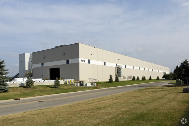
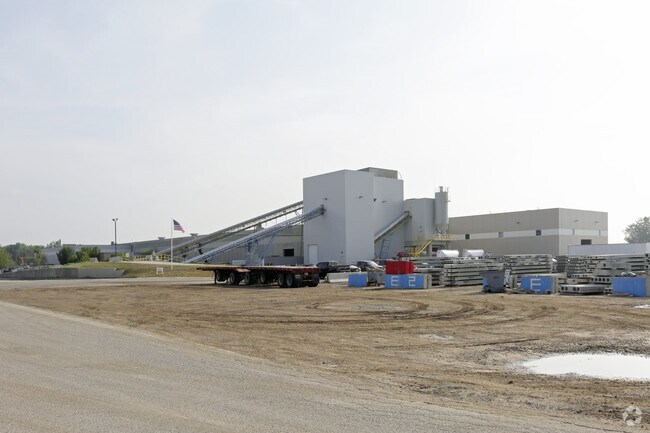
Property Record
3373 Busch Dr Sw, Grandville, MI 49418

NEARBY LISTINGS FOR SALE OR LEASE
Property Detail
3373 Busch Dr Sw
41-17-08-200-017
411708200017 PART OF NE 1/4 COM 655.0 FT S 89D 42M 55S W ALONG E&W 1/4 LINE FROM E 1/4 COR TH S 89D 42M 55S W ALONG E&W 1/4
Manufacturinglight
Kent
AE
Michigan
26081C0411D
13
2024
45.20 AC
2025
Southwestern Grand Rapids
013000
West Michigan
121,602 SF
Grand Rapids-Wyoming-Kentwood, MI
DEMOGRAPHICS near 3373 Busch Dr Sw
1 Mile
3 Mile
5 Mile
2024 Total Population
3,707
52,396
190,246
2029 Population
3,782
52,992
192,950
Pop Growth 2024-2029
+ 2.02%
+ 1.14%
+ 1.42%
Average Age
37
38
37
2024 Total Households
1,633
20,639
72,498
HH Growth 2024-2029
+ 2.33%
+ 1.25%
+ 1.54%
Median Household Inc
$62,772
$63,332
$65,126
Avg Household Size
2.20
2.40
2.50
2024 Avg HH Vehicles
2.00
2.00
2.00
Median Home Value
$178,124
$188,099
$204,965
Median Year Built
1973
1971
1970
Nearby Places
Map Layers
Map Styles
 Street
 Aerial
- Restaurants
- Banks
- Shops
- Fitness
- Groceries
PUBLIC TRANSPORTATION
COMMUTER RAIL
Grand Rapids Vernon J. Ehlers Station (Pere Marquette - Amtrak)
DRIVE
WALK
Distance
Grand Rapids Vernon J. Ehlers Station (Pere Marquette - Amtrak)
12 min
5.5 mi
AIRPORT
Gerald R Ford International
DRIVE
WALK
Distance
Gerald R Ford International
29 min
15.4 mi
Freight Ports
Port Milwaukee
DRIVE
WALK
Distance
Port Milwaukee
301 min
257.4 mi
Nearby Properties
Address
Land Use
TOTAL SIZE
Lot Size
Zoning
Address
Land Use
TOTAL SIZE
Lot Size
Zoning
79.40 AC
C-4
Address
Land Use
TOTAL SIZE
Lot Size
Zoning
899,034 SF
78.93 AC
B1
Address
Land Use
TOTAL SIZE
Lot Size
Zoning
12.64 AC
PUD
Address
Land Use
TOTAL SIZE
Lot Size
Zoning
307,361 SF
16.60 AC
R1-A
Address
Land Use
TOTAL SIZE
Lot Size
Zoning
398,607 SF
33.51 AC
R4
Address
Land Use
TOTAL SIZE
Lot Size
Zoning
87.39 AC
I2
Address
Land Use
TOTAL SIZE
Lot Size
Zoning
173,288 SF
4.17 AC
PUD
Address
Land Use
TOTAL SIZE
Lot Size
Zoning
29.13 AC
Address
Land Use
TOTAL SIZE
Lot Size
Zoning
293,441 SF
18 AC
I-1
Address
Land Use
TOTAL SIZE
Lot Size
Zoning
251,562 SF
15.56 AC
MZ
Address
Land Use
TOTAL SIZE
Lot Size
Zoning
162,228 SF
14.31 AC
R4
Address
Land Use
TOTAL SIZE
Lot Size
Zoning
222,785 SF
26.69 AC
CS
Address
Land Use
TOTAL SIZE
Lot Size
Zoning
87,414 SF
14.72 AC
PUD
Address
Land Use
TOTAL SIZE
Lot Size
Zoning
61 AC
R6
Address
Land Use
TOTAL SIZE
Lot Size
Zoning
155,304 SF
17.58 AC
R3-B
Address
Land Use
TOTAL SIZE
Lot Size
Zoning
116,832 SF
14.32 AC
R4
Address
Land Use
TOTAL SIZE
Lot Size
Zoning
246,880 SF
18.33 AC
I-2
Address
Land Use
TOTAL SIZE
Lot Size
Zoning
121,842 SF
9.42 AC
R4
Address
Land Use
TOTAL SIZE
Lot Size
Zoning
214,398 SF
18.66 AC
OS-2
Address
Land Use
TOTAL SIZE
Lot Size
Zoning
97,975 SF
12.88 AC
C-1
Address
Land Use
TOTAL SIZE
Lot Size
Zoning
14.69 AC
R3-B
Address
Land Use
TOTAL SIZE
Lot Size
Zoning
38,244 SF
3.17 AC
R1
Address
Land Use
TOTAL SIZE
Lot Size
Zoning
89,648 SF
3.17 AC
OS-2
Address
Land Use
TOTAL SIZE
Lot Size
Zoning
94,880 SF
10.57 AC
R4
Address
Land Use
TOTAL SIZE
Lot Size
Zoning
404,476 SF
13.07 AC
I2
Address
Land Use
TOTAL SIZE
Lot Size
Zoning
60,510 SF
13.84 AC
FBC
Address
Land Use
TOTAL SIZE
Lot Size
Zoning
92,778 SF
9.90 AC
PUD
Address
Land Use
TOTAL SIZE
Lot Size
Zoning
134,943 SF
5.01 AC
I2
Address
Land Use
TOTAL SIZE
Lot Size
Zoning
9 AC
R3-A
The World's #1 Commercial Real Estate Marketplace
Connect with us
© 2026 CoStar Group
The information above has been obtained from sources believed reliable. While we do not doubt its accuracy we have not verified it and make no guarantee, warranty or representation about it. It is your responsibility to independently confirm its accuracy and completeness. Any projections, opinions, assumptions, or estimates used are for example only and do not represent the current or future performance of the property. The value of this transaction to you depends on tax and other factors which should be evaluated by your tax, financial, and legal advisors. You and your advisors should conduct a careful, independent investigation of the property to determine to your satisfaction the suitability of the property for your needs.