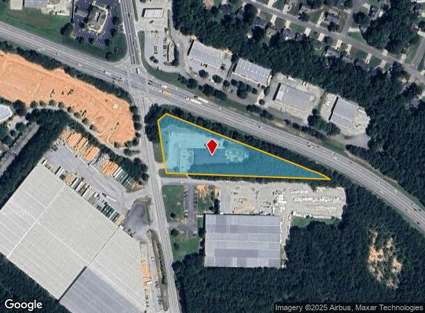
Property Record
3375 Florence Rd, Powder Springs, GA 30127
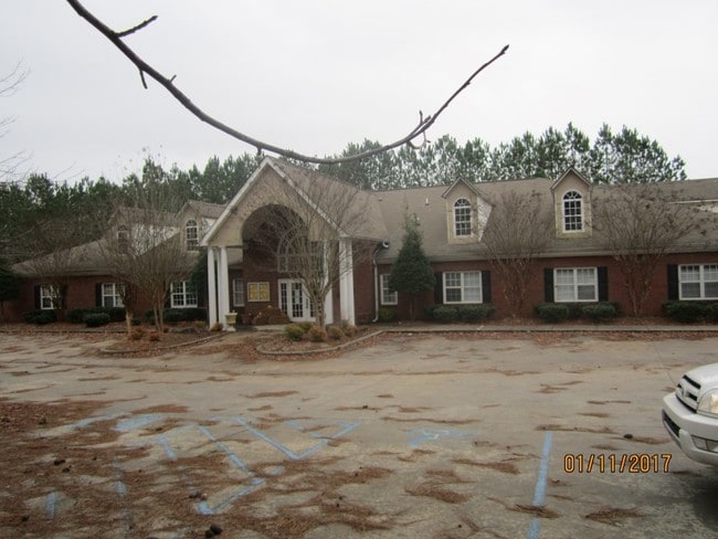
This Property Is For Sale
NEARBY LISTINGS FOR SALE OR LEASE
Property Detail
3375 Florence Rd
19-0731-0-086-0
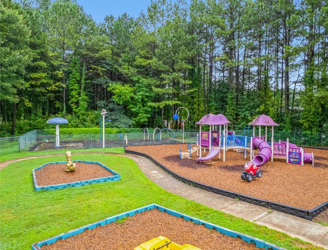
Landings/Kennesaw Mountain
Daycare
Cobb
X
Georgia
13067C0177G
1
2025
2.73 AC
2025
Powder Spring/Austell
031511
Atlanta
10,851 SF
Atlanta-Sandy Springs-Roswell, GA
DEMOGRAPHICS near 3375 Florence Rd
1 Mile
3 Mile
5 Mile
2024 Total Population
5,570
40,590
103,642
2029 Population
5,644
42,153
108,872
Pop Growth 2024-2029
+ 1.33%
+ 3.85%
+ 5.05%
Average Age
39
40
39
2024 Total Households
1,897
14,187
35,535
HH Growth 2024-2029
+ 1.32%
+ 4.08%
+ 5.20%
Median Household Inc
$96,865
$90,054
$90,942
Avg Household Size
2.90
2.80
2.90
2024 Avg HH Vehicles
2.00
2.00
2.00
Median Home Value
$300,704
$280,196
$275,660
Median Year Built
1995
1995
1993
Nearby Places
- Restaurants
- Banks
- Shops
- Fitness
- Groceries
PUBLIC TRANSPORTATION
AIRPORT
Hartsfield - Jackson Atlanta International
DRIVE
WALK
Distance
Hartsfield - Jackson Atlanta International
46 min
31.3 mi
Freight Ports
Georgia Ports - Savannah
DRIVE
WALK
Distance
Georgia Ports - Savannah
309 min
270.6 mi
Nearby Properties
Address
Land Use
TOTAL SIZE
Lot Size
Zoning
Address
Land Use
TOTAL SIZE
Lot Size
Zoning
18.80 AC
MXU
Address
Land Use
TOTAL SIZE
Lot Size
Zoning
9,882 SF
4.61 AC
CBD
Address
Land Use
TOTAL SIZE
Lot Size
Zoning
Address
Land Use
TOTAL SIZE
Lot Size
Zoning
15.02 AC
Address
Land Use
TOTAL SIZE
Lot Size
Zoning
171,510 SF
7.63 AC
MXU
Address
Land Use
TOTAL SIZE
Lot Size
Zoning
350,000 SF
24 AC
HI
Address
Land Use
TOTAL SIZE
Lot Size
Zoning
141,658 SF
17.36 AC
PSC
Address
Land Use
TOTAL SIZE
Lot Size
Zoning
171,184 SF
14.63 AC
PSC
Address
Land Use
TOTAL SIZE
Lot Size
Zoning
79,348 SF
12.04 AC
CRC
Address
Land Use
TOTAL SIZE
Lot Size
Zoning
83,054 SF
11.06 AC
NRC/WS
Address
Land Use
TOTAL SIZE
Lot Size
Zoning
133,006 SF
15.53 AC
PSC
Address
Land Use
TOTAL SIZE
Lot Size
Zoning
12,374 SF
1.42 AC
CBD
Address
Land Use
TOTAL SIZE
Lot Size
Zoning
67,341 SF
9.07 AC
GC
Address
Land Use
TOTAL SIZE
Lot Size
Zoning
101,340 SF
4.24 AC
CRC
Address
Land Use
TOTAL SIZE
Lot Size
Zoning
202,176 SF
24.10 AC
R-30
Address
Land Use
TOTAL SIZE
Lot Size
Zoning
104,746 SF
16.19 AC
CRC/LRO
Address
Land Use
TOTAL SIZE
Lot Size
Zoning
185,183 SF
6.99 AC
OI
Address
Land Use
TOTAL SIZE
Lot Size
Zoning
12.01 AC
CRC
Address
Land Use
TOTAL SIZE
Lot Size
Zoning
103,185 SF
13.41 AC
B2
Address
Land Use
TOTAL SIZE
Lot Size
Zoning
367,298 SF
15.38 AC
LI
Address
Land Use
TOTAL SIZE
Lot Size
Zoning
86,556 SF
8.10 AC
PSC
Address
Land Use
TOTAL SIZE
Lot Size
Zoning
109,540 SF
13.99 AC
B2
Address
Land Use
TOTAL SIZE
Lot Size
Zoning
72,580 SF
7.05 AC
LI
Address
Land Use
TOTAL SIZE
Lot Size
Zoning
56,140 SF
8.24 AC
CRC
Address
Land Use
TOTAL SIZE
Lot Size
Zoning
57,600 SF
2.91 AC
PSC
Address
Land Use
TOTAL SIZE
Lot Size
Zoning
67,875 SF
1.91 AC
MXU
Address
Land Use
TOTAL SIZE
Lot Size
Zoning
Address
Land Use
TOTAL SIZE
Lot Size
Zoning
87,362 SF
20 AC
LI
Address
Land Use
TOTAL SIZE
Lot Size
Zoning
16.72 AC
R-20
Address
Land Use
TOTAL SIZE
Lot Size
Zoning
73,314 SF
5.30 AC
CRC
The World's #1 Commercial Real Estate Marketplace
Connect with us
© 2025 CoStar Group
The information above has been obtained from sources believed reliable. While we do not doubt its accuracy we have not verified it and make no guarantee, warranty or representation about it. It is your responsibility to independently confirm its accuracy and completeness. Any projections, opinions, assumptions, or estimates used are for example only and do not represent the current or future performance of the property. The value of this transaction to you depends on tax and other factors which should be evaluated by your tax, financial, and legal advisors. You and your advisors should conduct a careful, independent investigation of the property to determine to your satisfaction the suitability of the property for your needs.