Property Record
3376 Foothill Rd, Carpinteria, CA 93013

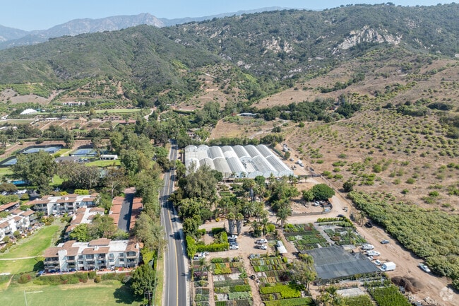
Property Detail
3376 Foothill Rd
Santa Maria-Santa Barbara, CA
TRACT 6
005-280-026
Santa Barbara
Horticulturegrowinghousesagricultural
California
AGI10
6
B and X Area of moderate flood hazard, usually the area between the limits of the 100-year and 500-year floods.
9.13 AC
2024
S Santa Barbara Coastal
2025
Santa Barbara/Sta Maria/Goleta
001706
NEARBY LISTINGS FOR SALE OR LEASE
DEMOGRAPHICS near 3376 Foothill Rd
1 mile
3 mile
5 mile
2025 Total Population
1,244
13,016
24,612
2030 Population
1,254
13,147
24,948
Pop Growth 2025-2030
+ 0.80%
+ 1.01%
+ 1.37%
Average Age
48
44
45
2025 Total Households
507
5,082
9,847
HH Growth 2025-2030
+ 0.99%
+ 1.12%
+ 1.47%
Median Household Inc
$116,145
$109,986
$122,755
Avg Household Size
2.40
2.50
2.40
2025 Avg HH Vehicles
2.00
2.00
2.00
Median Home Value
$1,060,744
$1,083,626
$1,099,302
Median Year Built
1978
1975
1973
Nearby Places
Map Layers
Map Styles
 Street
 Aerial
Transit
 Traffic
 Biking
Places
Listings with unknown addresses are not visible on the map
- Restaurants
- Banks
- Shops
- Fitness
- Groceries
PUBLIC TRANSPORTATION
COMMUTER RAIL
Drive
Walk
Distance
7 min
3.3 mi
Drive
Walk
Distance
13 min
8.5 mi
AIRPORT
Santa Barbara Municipal
Drive
Walk
Distance
Santa Barbara Municipal
25 min
18.6 mi
Freight Ports
The Port of Hueneme
Drive
Walk
Distance
The Port of Hueneme
45 min
31.9 mi
Nearby Properties
Address
Land Use
TOTAL SIZE
Lot Size
Zoning
Address
Land Use
TOTAL SIZE
Lot Size
Zoning
51,425 SF
28.35 AC
MRP
Address
Land Use
TOTAL SIZE
Lot Size
Zoning
2.68 AC
AGI5
Address
Land Use
TOTAL SIZE
Lot Size
Zoning
1,280 SF
76.87 AC
2E1
Address
Land Use
TOTAL SIZE
Lot Size
Zoning
14.66 AC
AGI10
Address
Land Use
TOTAL SIZE
Lot Size
Zoning
10.26 AC
3E1
Address
Land Use
TOTAL SIZE
Lot Size
Zoning
124,667 SF
32.92 AC
10E1
Address
Land Use
TOTAL SIZE
Lot Size
Zoning
8,010 SF
10 AC
AGI10
Address
Land Use
TOTAL SIZE
Lot Size
Zoning
1.95 AC
Address
Land Use
TOTAL SIZE
Lot Size
Zoning
0.70 AC
Address
Land Use
TOTAL SIZE
Lot Size
Zoning
19 AC
AGI10
Address
Land Use
TOTAL SIZE
Lot Size
Zoning
6.84 AC
5E1
Address
Land Use
TOTAL SIZE
Lot Size
Zoning
Address
Land Use
TOTAL SIZE
Lot Size
Zoning
7,657 SF
8.12 AC
AGI10
Address
Land Use
TOTAL SIZE
Lot Size
Zoning
2.69 AC
Address
Land Use
TOTAL SIZE
Lot Size
Zoning
3.64 AC
3E1
Address
Land Use
TOTAL SIZE
Lot Size
Zoning
Address
Land Use
TOTAL SIZE
Lot Size
Zoning
Address
Land Use
TOTAL SIZE
Lot Size
Zoning
3,377 SF
21.62 AC
AGI20
Address
Land Use
TOTAL SIZE
Lot Size
Zoning
1.59 AC
Address
Land Use
TOTAL SIZE
Lot Size
Zoning
56 AC
AGI40
Address
Land Use
TOTAL SIZE
Lot Size
Zoning
1,518 SF
46.75 AC
5E1
Address
Land Use
TOTAL SIZE
Lot Size
Zoning
11.30 AC
AGI20
Address
Land Use
TOTAL SIZE
Lot Size
Zoning
6 AC
AGI10
Address
Land Use
TOTAL SIZE
Lot Size
Zoning
6.24 AC
AGI5
Address
Land Use
TOTAL SIZE
Lot Size
Zoning
2,229 SF
0.12 AC
Address
Land Use
TOTAL SIZE
Lot Size
Zoning
40.05 AC
AGI40
Address
Land Use
TOTAL SIZE
Lot Size
Zoning
28.24 AC
AGI10
Address
Land Use
TOTAL SIZE
Lot Size
Zoning
24.03 AC
AGI20
Address
Land Use
TOTAL SIZE
Lot Size
Zoning
2.88 AC
Address
Land Use
TOTAL SIZE
Lot Size
Zoning
5,093 SF
10 AC
AGI20
The World's #1 Commercial Real Estate Marketplace
Connect with us
© 2026 CoStar Group
The information above has been obtained from sources believed reliable. While we do not doubt its accuracy we have not verified it and make no guarantee, warranty or representation about it. It is your responsibility to independently confirm its accuracy and completeness. Any projections, opinions, assumptions, or estimates used are for example only and do not represent the current or future performance of the property. The value of this transaction to you depends on tax and other factors which should be evaluated by your tax, financial, and legal advisors. You and your advisors should conduct a careful, independent investigation of the property to determine to your satisfaction the suitability of the property for your needs.