Property Record
338 N Pea Ridge Rd, Pittsboro, NC 27312

NEARBY LISTINGS FOR SALE OR LEASE
-
-
View all Pittsboro listings for sale on LoopNet.com
Property Detail
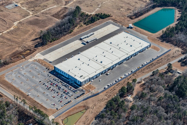
338 N Pea Ridge Rd
Raleigh/Durham
Moncure Commercial
Durham-Chapel Hill, NC
LOT 1 AC 58.1 BK 2023 PG 134
0095390
Chatham
Policefirecivildefense
North Carolina
2025
1
2025
58.10 AC
020801
Chatham County
338,013 SF
DEMOGRAPHICS near 338 N Pea Ridge Rd
1 Mile
3 Mile
5 Mile
2024 Total Population
168
1,655
3,958
2029 Population
184
1,817
4,354
Pop Growth 2024-2029
+ 9.52%
+ 9.79%
+ 10.01%
Average Age
44
44
43
2024 Total Households
68
649
1,533
HH Growth 2024-2029
+ 8.82%
+ 10.02%
+ 10.11%
Median Household Inc
$59,374
$63,369
$64,059
Avg Household Size
2.50
2.50
2.50
2024 Avg HH Vehicles
3.00
2.00
3.00
Median Home Value
$287,499
$314,912
$270,231
Median Year Built
1992
1992
1991
Nearby Places
Map Layers
Map Styles
 Street
 Aerial
- Restaurants
- Banks
- Shops
- Fitness
- Groceries
PUBLIC TRANSPORTATION
AIRPORT
Raleigh-Durham International
DRIVE
WALK
Distance
Raleigh-Durham International
38 min
30.1 mi
Freight Ports
Port of Wilmington
DRIVE
WALK
Distance
Port of Wilmington
181 min
158.4 mi
Nearby Properties
Address
Land Use
TOTAL SIZE
Lot Size
Zoning
Address
Land Use
TOTAL SIZE
Lot Size
Zoning
280,718 SF
296.13 AC
IND-H
Address
Land Use
TOTAL SIZE
Lot Size
Zoning
855.31 AC
IND-H
Address
Land Use
TOTAL SIZE
Lot Size
Zoning
252,798 SF
103.69 AC
IND-H
Address
Land Use
TOTAL SIZE
Lot Size
Zoning
38,640 SF
38.35 AC
CD-CB
Address
Land Use
TOTAL SIZE
Lot Size
Zoning
1,264 SF
483.06 AC
IND-H
Address
Land Use
TOTAL SIZE
Lot Size
Zoning
181,419 SF
107.89 AC
IND-H
Address
Land Use
TOTAL SIZE
Lot Size
Zoning
231.24 AC
IND-H
Address
Land Use
TOTAL SIZE
Lot Size
Zoning
220.64 AC
IND-H
Address
Land Use
TOTAL SIZE
Lot Size
Zoning
255.97 AC
IND-H
Address
Land Use
TOTAL SIZE
Lot Size
Zoning
151.61 AC
R-1
Address
Land Use
TOTAL SIZE
Lot Size
Zoning
1,216 SF
69.30 AC
R-1
Address
Land Use
TOTAL SIZE
Lot Size
Zoning
11,928 SF
28.69 AC
IND-H
Address
Land Use
TOTAL SIZE
Lot Size
Zoning
1,920 SF
35.12 AC
R-1
Address
Land Use
TOTAL SIZE
Lot Size
Zoning
13,600 SF
10.01 AC
B-1
Address
Land Use
TOTAL SIZE
Lot Size
Zoning
14,283 SF
4 AC
OI
Address
Land Use
TOTAL SIZE
Lot Size
Zoning
868 SF
193.41 AC
R-1
Address
Land Use
TOTAL SIZE
Lot Size
Zoning
123.56 AC
IND-H
Address
Land Use
TOTAL SIZE
Lot Size
Zoning
720 SF
33.75 AC
HEAVY INDU
Address
Land Use
TOTAL SIZE
Lot Size
Zoning
4,834 SF
8.30 AC
OI
Address
Land Use
TOTAL SIZE
Lot Size
Zoning
735 SF
274.62 AC
RESIDENTIA
Address
Land Use
TOTAL SIZE
Lot Size
Zoning
6,091 SF
1.97 AC
NB
Address
Land Use
TOTAL SIZE
Lot Size
Zoning
1,428 SF
10.35 AC
CU-B-1
Address
Land Use
TOTAL SIZE
Lot Size
Zoning
924 SF
14.19 AC
MH-NC
Address
Land Use
TOTAL SIZE
Lot Size
Zoning
5,900 SF
9.47 AC
B-1
Address
Land Use
TOTAL SIZE
Lot Size
Zoning
273.49 AC
CU-IND-H
Address
Land Use
TOTAL SIZE
Lot Size
Zoning
65.23 AC
R-1
Address
Land Use
TOTAL SIZE
Lot Size
Zoning
132.13 AC
IND-H
Address
Land Use
TOTAL SIZE
Lot Size
Zoning
12.30 AC
R-1
Address
Land Use
TOTAL SIZE
Lot Size
Zoning
4,952 SF
28.19 AC
R-1
The World's #1 Commercial Real Estate Marketplace
Connect with us
© 2025 CoStar Group
The information above has been obtained from sources believed reliable. While we do not doubt its accuracy we have not verified it and make no guarantee, warranty or representation about it. It is your responsibility to independently confirm its accuracy and completeness. Any projections, opinions, assumptions, or estimates used are for example only and do not represent the current or future performance of the property. The value of this transaction to you depends on tax and other factors which should be evaluated by your tax, financial, and legal advisors. You and your advisors should conduct a careful, independent investigation of the property to determine to your satisfaction the suitability of the property for your needs.