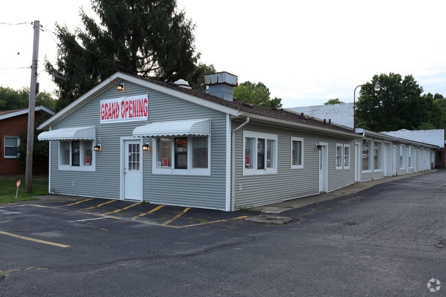
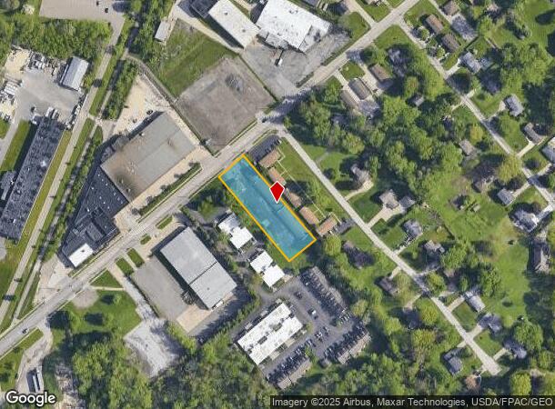
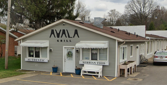
Property Record
338 Northeast Ave, Tallmadge, OH 44278

Current Lease Availabilities
NEARBY LISTINGS FOR SALE OR LEASE
Property Detail
338 Northeast Ave
60-03634
TR 7 LOT 9 SE OF RD
Regionalshoppingcenterormallwithanchorstore
Summit
X
Ohio
39153C0210F
9
2023
0.92 AC
2025
Akron
530902
Cleveland
9,560 SF
Akron, OH
DEMOGRAPHICS near 338 Northeast Ave
1 Mile
3 Mile
5 Mile
2024 Total Population
4,281
51,180
182,237
2029 Population
4,203
50,504
180,923
Pop Growth 2024-2029
(1.82%)
(1.32%)
(0.72%)
Average Age
45
42
40
2024 Total Households
1,896
22,263
78,122
HH Growth 2024-2029
(1.95%)
(1.42%)
(0.78%)
Median Household Inc
$87,044
$60,497
$56,466
Avg Household Size
2.20
2.20
2.20
2024 Avg HH Vehicles
2.00
2.00
2.00
Median Home Value
$205,888
$157,672
$150,986
Median Year Built
1966
1965
1959
Nearby Places
- Restaurants
- Banks
- Shops
- Fitness
- Groceries
PUBLIC TRANSPORTATION
COMMUTER RAIL
Akron Northside (National Park Scenic Railway - Cuyahoga Valley Scenic Railroad)
DRIVE
WALK
Distance
Akron Northside (National Park Scenic Railway - Cuyahoga Valley Scenic Railroad)
14 min
5.5 mi
Big Bend (National Park Scenic Railway - Cuyahoga Valley Scenic Railroad)
DRIVE
WALK
Distance
Big Bend (National Park Scenic Railway - Cuyahoga Valley Scenic Railroad)
19 min
7.9 mi
AIRPORT
Akron-Canton Regional
DRIVE
WALK
Distance
Akron-Canton Regional
28 min
18.2 mi
Freight Ports
Port of Toledo
DRIVE
WALK
Distance
Port of Toledo
162 min
135.3 mi
Nearby Properties
Address
Land Use
TOTAL SIZE
Lot Size
Zoning
Address
Land Use
TOTAL SIZE
Lot Size
Zoning
194,492 SF
37.82 AC
Address
Land Use
TOTAL SIZE
Lot Size
Zoning
77,663 SF
83.47 AC
Address
Land Use
TOTAL SIZE
Lot Size
Zoning
815,100 SF
66.78 AC
Address
Land Use
TOTAL SIZE
Lot Size
Zoning
176,533 SF
62.50 AC
Address
Land Use
TOTAL SIZE
Lot Size
Zoning
229,392 SF
12.31 AC
Address
Land Use
TOTAL SIZE
Lot Size
Zoning
Address
Land Use
TOTAL SIZE
Lot Size
Zoning
193,894 SF
24.63 AC
Address
Land Use
TOTAL SIZE
Lot Size
Zoning
131,788 SF
13.99 AC
Address
Land Use
TOTAL SIZE
Lot Size
Zoning
48,734 SF
18.12 AC
Address
Land Use
TOTAL SIZE
Lot Size
Zoning
226,050 SF
24.49 AC
Address
Land Use
TOTAL SIZE
Lot Size
Zoning
161,806 SF
1.92 AC
Address
Land Use
TOTAL SIZE
Lot Size
Zoning
538,138 SF
37.59 AC
Address
Land Use
TOTAL SIZE
Lot Size
Zoning
90,014 SF
5.84 AC
Address
Land Use
TOTAL SIZE
Lot Size
Zoning
95,696 SF
8.29 AC
Address
Land Use
TOTAL SIZE
Lot Size
Zoning
5.84 AC
Address
Land Use
TOTAL SIZE
Lot Size
Zoning
212,628 SF
27.25 AC
Address
Land Use
TOTAL SIZE
Lot Size
Zoning
374,370 SF
27.79 AC
Address
Land Use
TOTAL SIZE
Lot Size
Zoning
88,682 SF
11.55 AC
Address
Land Use
TOTAL SIZE
Lot Size
Zoning
72,162 SF
4.76 AC
Address
Land Use
TOTAL SIZE
Lot Size
Zoning
107,704 SF
10.13 AC
Address
Land Use
TOTAL SIZE
Lot Size
Zoning
84,018 SF
2.07 AC
Address
Land Use
TOTAL SIZE
Lot Size
Zoning
141,288 SF
20.75 AC
Address
Land Use
TOTAL SIZE
Lot Size
Zoning
0.34 AC
Address
Land Use
TOTAL SIZE
Lot Size
Zoning
105,404 SF
31.05 AC
Address
Land Use
TOTAL SIZE
Lot Size
Zoning
5,863 SF
343.43 AC
Address
Land Use
TOTAL SIZE
Lot Size
Zoning
Address
Land Use
TOTAL SIZE
Lot Size
Zoning
38,532 SF
17.80 AC
Address
Land Use
TOTAL SIZE
Lot Size
Zoning
Address
Land Use
TOTAL SIZE
Lot Size
Zoning
76,160 SF
12.34 AC
Address
Land Use
TOTAL SIZE
Lot Size
Zoning
55,428 SF
18.66 AC
The World's #1 Commercial Real Estate Marketplace
Connect with us
© 2025 CoStar Group
The information above has been obtained from sources believed reliable. While we do not doubt its accuracy we have not verified it and make no guarantee, warranty or representation about it. It is your responsibility to independently confirm its accuracy and completeness. Any projections, opinions, assumptions, or estimates used are for example only and do not represent the current or future performance of the property. The value of this transaction to you depends on tax and other factors which should be evaluated by your tax, financial, and legal advisors. You and your advisors should conduct a careful, independent investigation of the property to determine to your satisfaction the suitability of the property for your needs.