Property Record
338 Walnut Ave Se, Roanoke, VA 24014
NEARBY LISTINGS FOR SALE OR LEASE
Property Detail
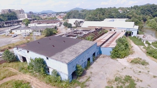
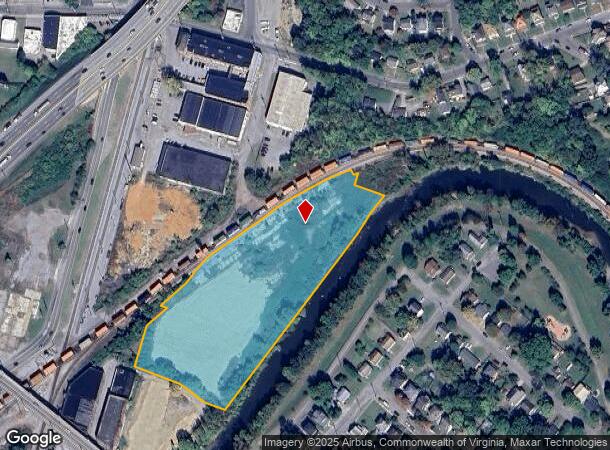
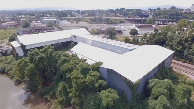
338 Walnut Ave Se
Roanoke, VA
Plat Showing Two Parcels Of Land Lying N
403-0301
LOT 1 N PT 4 BLK 7 O S SEC SE4
Vacantlandnec
Roanoke City
AE
Virginia
51161C0168G
1
2025
5.50 AC
2025
Southwest Roanoke
002700
Roanoke
3,184 SF
DEMOGRAPHICS near 338 Walnut Ave Se
1 Mile
3 Mile
5 Mile
2024 Total Population
11,011
65,438
136,155
2029 Population
10,835
64,229
134,121
Pop Growth 2024-2029
(1.60%)
(1.85%)
(1.49%)
Average Age
38
40
41
2024 Total Households
5,369
29,552
60,200
HH Growth 2024-2029
(1.47%)
(1.86%)
(1.50%)
Median Household Inc
$47,124
$48,191
$52,607
Avg Household Size
1.90
2.10
2.20
2024 Avg HH Vehicles
1.00
2.00
2.00
Median Home Value
$143,981
$170,282
$181,272
Median Year Built
1947
1954
1965
Nearby Places
Map Layers
Map Styles
 Street
 Aerial
- Restaurants
- Banks
- Shops
- Fitness
- Groceries
PUBLIC TRANSPORTATION
COMMUTER RAIL
Roanoke (Northeast Regional - Amtrak)
DRIVE
WALK
Distance
Roanoke (Northeast Regional - Amtrak)
4 min
20 min
1.0 mi
AIRPORT
Roanoke/Blacksburg Regional (Woodrum Field)
DRIVE
WALK
Distance
Roanoke/Blacksburg Regional (Woodrum Field)
13 min
6.0 mi
Freight Ports
Virginia Port Authority - Richmond
DRIVE
WALK
Distance
Virginia Port Authority - Richmond
220 min
162.2 mi
SALE & LEASE HISTORY
LISTING DATE
SALE/LEASE

Jul 03, 2017
For Sale
Nearby Properties
Address
Land Use
TOTAL SIZE
Lot Size
Zoning
Address
Land Use
TOTAL SIZE
Lot Size
Zoning
998,139 SF
20.12 AC
INPUD
Address
Land Use
TOTAL SIZE
Lot Size
Zoning
370 SF
105.25 AC
I-2
Address
Land Use
TOTAL SIZE
Lot Size
Zoning
41,443 SF
96.33 AC
INPUD
Address
Land Use
TOTAL SIZE
Lot Size
Zoning
476,613 SF
5.29 AC
D
Address
Land Use
TOTAL SIZE
Lot Size
Zoning
96,620 SF
26.84 AC
D
Address
Land Use
TOTAL SIZE
Lot Size
Zoning
217,815 SF
3.02 AC
INPUD
Address
Land Use
TOTAL SIZE
Lot Size
Zoning
87,406 SF
1.15 AC
D
Address
Land Use
TOTAL SIZE
Lot Size
Zoning
211,622 SF
2.18 AC
INPUD
Address
Land Use
TOTAL SIZE
Lot Size
Zoning
3,404 SF
17.41 AC
MXPUD
Address
Land Use
TOTAL SIZE
Lot Size
Zoning
47,181 SF
33.94 AC
INPUD
Address
Land Use
TOTAL SIZE
Lot Size
Zoning
19,734 SF
34.83 AC
INPUD
Address
Land Use
TOTAL SIZE
Lot Size
Zoning
1.51 AC
INPUD
Address
Land Use
TOTAL SIZE
Lot Size
Zoning
262,715 SF
5.09 AC
D
Address
Land Use
TOTAL SIZE
Lot Size
Zoning
138,261 SF
22.24 AC
CLS
Address
Land Use
TOTAL SIZE
Lot Size
Zoning
71,696 SF
71.64 AC
INPUD/ROS
Address
Land Use
TOTAL SIZE
Lot Size
Zoning
1.25 AC
D
Address
Land Use
TOTAL SIZE
Lot Size
Zoning
504,343 SF
2.80 AC
INPUD
Address
Land Use
TOTAL SIZE
Lot Size
Zoning
59,641 SF
5.63 AC
INPUD
Address
Land Use
TOTAL SIZE
Lot Size
Zoning
81,500 SF
0.63 AC
D
Address
Land Use
TOTAL SIZE
Lot Size
Zoning
12,220 SF
5.09 AC
D
Address
Land Use
TOTAL SIZE
Lot Size
Zoning
150,151 SF
0.84 AC
D
Address
Land Use
TOTAL SIZE
Lot Size
Zoning
65,502 SF
2.89 AC
INPUD
Address
Land Use
TOTAL SIZE
Lot Size
Zoning
33,249 SF
5.50 AC
D
Address
Land Use
TOTAL SIZE
Lot Size
Zoning
141,056 SF
2.49 AC
D
Address
Land Use
TOTAL SIZE
Lot Size
Zoning
206,418 SF
1.50 AC
D
Address
Land Use
TOTAL SIZE
Lot Size
Zoning
100,606 SF
2.10 AC
INPUD
Address
Land Use
TOTAL SIZE
Lot Size
Zoning
67,486 SF
3.99 AC
RMF
Address
Land Use
TOTAL SIZE
Lot Size
Zoning
73,575 SF
2.52 AC
D
Address
Land Use
TOTAL SIZE
Lot Size
Zoning
122,814 SF
0.98 AC
INPUD
Address
Land Use
TOTAL SIZE
Lot Size
Zoning
238,125 SF
0.37 AC
D
The World's #1 Commercial Real Estate Marketplace
Connect with us
© 2025 CoStar Group
The information above has been obtained from sources believed reliable. While we do not doubt its accuracy we have not verified it and make no guarantee, warranty or representation about it. It is your responsibility to independently confirm its accuracy and completeness. Any projections, opinions, assumptions, or estimates used are for example only and do not represent the current or future performance of the property. The value of this transaction to you depends on tax and other factors which should be evaluated by your tax, financial, and legal advisors. You and your advisors should conduct a careful, independent investigation of the property to determine to your satisfaction the suitability of the property for your needs.