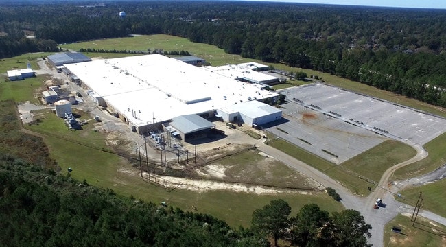
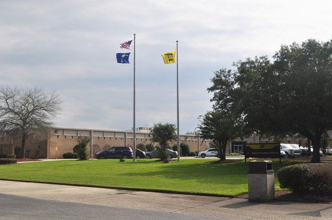
Property Record
3381 Pine Needles Rd, Florence, SC 29501

Current Lease Availabilities
Property Detail
3381 Pine Needles Rd
00074-01-019
EBENEZER/PINENEEDLE R/W
Manufacturinglight
FLORENCE
RU1
South Carolina
B and X Area of moderate flood hazard, usually the area between the limits of the 100-year and 500-year floods.
95.85 AC
2025
Florence/Dillon
2025
Other Market Areas
000201
Florence, SC
454,390 SF
NEARBY LISTINGS FOR SALE OR LEASE
-
-
View all Florence listings for lease on LoopNet.com
DEMOGRAPHICS near 3381 Pine Needles Rd
1 mile
3 mile
5 mile
2025 Total Population
3,503
26,889
53,978
2030 Population
3,491
27,037
54,400
Pop Growth 2025-2030
(0.34%)
+ 0.55%
+ 0.78%
Average Age
42
41
41
2025 Total Households
1,391
10,900
22,030
HH Growth 2025-2030
(0.36%)
+ 0.44%
+ 0.73%
Median Household Inc
$95,847
$84,883
$71,472
Avg Household Size
2.50
2.40
2.40
2025 Avg HH Vehicles
2.00
2.00
2.00
Median Home Value
$284,947
$273,666
$245,126
Median Year Built
1990
1989
1985
Nearby Places
Map Layers
Map Styles
 Street
 Aerial
Transit
 Traffic
 Biking
Places
Listings with unknown addresses are not visible on the map
- Restaurants
- Banks
- Shops
- Fitness
- Groceries
PUBLIC TRANSPORTATION
COMMUTER RAIL
Florence Amtrak Station (Palmetto - Amtrak, Silver Meteor - Amtrak)
Drive
Walk
Distance
Florence Amtrak Station (Palmetto - Amtrak, Silver Meteor - Amtrak)
15 min
6.7 mi
Freight Ports
North Charleston Terminal
Drive
Walk
Distance
North Charleston Terminal
137 min
120.5 mi
Nearby Properties
Address
Land Use
TOTAL SIZE
Lot Size
Zoning
Address
Land Use
TOTAL SIZE
Lot Size
Zoning
492,953 SF
68.41 AC
PDD
Address
Land Use
TOTAL SIZE
Lot Size
Zoning
194,083 SF
27.70 AC
B3
Address
Land Use
TOTAL SIZE
Lot Size
Zoning
97,000 SF
50.87 AC
Address
Land Use
TOTAL SIZE
Lot Size
Zoning
7,746 SF
9.01 AC
Address
Land Use
TOTAL SIZE
Lot Size
Zoning
119,211 SF
2.98 AC
Address
Land Use
TOTAL SIZE
Lot Size
Zoning
13,198 SF
12.29 AC
Address
Land Use
TOTAL SIZE
Lot Size
Zoning
218,026 SF
27.49 AC
Address
Land Use
TOTAL SIZE
Lot Size
Zoning
49,000 SF
9.20 AC
Address
Land Use
TOTAL SIZE
Lot Size
Zoning
900 SF
17.01 AC
Address
Land Use
TOTAL SIZE
Lot Size
Zoning
101,390 SF
2.31 AC
Address
Land Use
TOTAL SIZE
Lot Size
Zoning
Address
Land Use
TOTAL SIZE
Lot Size
Zoning
3,732 SF
0.86 AC
Address
Land Use
TOTAL SIZE
Lot Size
Zoning
2,500 SF
0.80 AC
Address
Land Use
TOTAL SIZE
Lot Size
Zoning
49,190 SF
5.40 AC
Address
Land Use
TOTAL SIZE
Lot Size
Zoning
8,800 SF
15.25 AC
Address
Land Use
TOTAL SIZE
Lot Size
Zoning
16,600 SF
11.03 AC
Address
Land Use
TOTAL SIZE
Lot Size
Zoning
85,251 SF
2 AC
Address
Land Use
TOTAL SIZE
Lot Size
Zoning
99,628 SF
19.35 AC
Address
Land Use
TOTAL SIZE
Lot Size
Zoning
1,920 SF
13.25 AC
R5
Address
Land Use
TOTAL SIZE
Lot Size
Zoning
31,860 SF
12.23 AC
PDD
Address
Land Use
TOTAL SIZE
Lot Size
Zoning
89,105 SF
6.24 AC
Address
Land Use
TOTAL SIZE
Lot Size
Zoning
12,498 SF
10.56 AC
Address
Land Use
TOTAL SIZE
Lot Size
Zoning
86.02 AC
Address
Land Use
TOTAL SIZE
Lot Size
Zoning
66,833 SF
2.74 AC
Address
Land Use
TOTAL SIZE
Lot Size
Zoning
72,270 SF
3.80 AC
PDD
Address
Land Use
TOTAL SIZE
Lot Size
Zoning
125,000 SF
7.92 AC
Address
Land Use
TOTAL SIZE
Lot Size
Zoning
114,613 SF
11.74 AC
Address
Land Use
TOTAL SIZE
Lot Size
Zoning
63,070 SF
10.26 AC
Address
Land Use
TOTAL SIZE
Lot Size
Zoning
35,770 SF
6.40 AC
B3
The World's #1 Commercial Real Estate Marketplace
Connect with us
© 2026 CoStar Group
The information above has been obtained from sources believed reliable. While we do not doubt its accuracy we have not verified it and make no guarantee, warranty or representation about it. It is your responsibility to independently confirm its accuracy and completeness. Any projections, opinions, assumptions, or estimates used are for example only and do not represent the current or future performance of the property. The value of this transaction to you depends on tax and other factors which should be evaluated by your tax, financial, and legal advisors. You and your advisors should conduct a careful, independent investigation of the property to determine to your satisfaction the suitability of the property for your needs.