Property Record
3386 W Currahee St, Toccoa, GA 30577
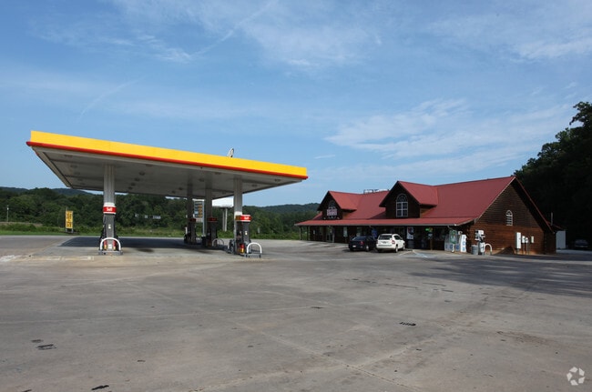

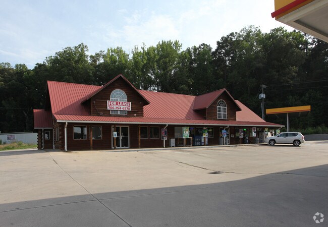
Property Detail
3386 W Currahee St
021D-073
GA HWY 13-US HWY 123
Conveniencestore
Stephens
CG
Georgia
B and X Area of moderate flood hazard, usually the area between the limits of the 100-year and 500-year floods.
2.68 AC
2025
Georgia Northeast
2025
Other Market Areas
970401
Toccoa, GA
4,008 SF
NEARBY LISTINGS FOR SALE OR LEASE
DEMOGRAPHICS near 3386 W Currahee St
1 mile
3 mile
5 mile
2025 Total Population
543
6,112
16,448
2030 Population
558
6,298
16,796
Pop Growth 2025-2030
+ 2.76%
+ 3.04%
+ 2.12%
Average Age
45
43
42
2025 Total Households
218
2,437
6,497
HH Growth 2025-2030
+ 2.29%
+ 2.95%
+ 2.03%
Median Household Inc
$72,499
$52,757
$52,732
Avg Household Size
2.50
2.40
2.40
2025 Avg HH Vehicles
2.00
2.00
2.00
Median Home Value
$199,122
$159,466
$184,477
Median Year Built
1983
1976
1977
Nearby Places
Map Layers
Map Styles
 Street
 Aerial
Layers
 Traffic
 Biking
Places
Listings with unknown addresses are not visible on the map
- Restaurants
- Banks
- Shops
- Fitness
- Groceries
PUBLIC TRANSPORTATION
COMMUTER RAIL
Drive
Walk
Distance
7 min
5.1 mi
Nearby Properties
Address
Land Use
TOTAL SIZE
Lot Size
Zoning
Address
Land Use
TOTAL SIZE
Lot Size
Zoning
11,650 AC
GV
Address
Land Use
TOTAL SIZE
Lot Size
Zoning
0.58 AC
CI
Address
Land Use
TOTAL SIZE
Lot Size
Zoning
68,998 SF
24.53 AC
CG
Address
Land Use
TOTAL SIZE
Lot Size
Zoning
241,310 SF
30.85 AC
CI
Address
Land Use
TOTAL SIZE
Lot Size
Zoning
131,717 SF
23.47 AC
CI
Address
Land Use
TOTAL SIZE
Lot Size
Zoning
2,880 SF
7.72 AC
R-III
Address
Land Use
TOTAL SIZE
Lot Size
Zoning
27,013 SF
3.25 AC
R-IA
Address
Land Use
TOTAL SIZE
Lot Size
Zoning
9,068 SF
4.15 AC
R-IA
Address
Land Use
TOTAL SIZE
Lot Size
Zoning
2,104 SF
6.76 AC
R-III
Address
Land Use
TOTAL SIZE
Lot Size
Zoning
10,837 SF
9.60 AC
CG
Address
Land Use
TOTAL SIZE
Lot Size
Zoning
7,000 SF
6.59 AC
CI
Address
Land Use
TOTAL SIZE
Lot Size
Zoning
21,468 SF
2.33 AC
R-II
Address
Land Use
TOTAL SIZE
Lot Size
Zoning
20,241 SF
5.22 AC
CG
Address
Land Use
TOTAL SIZE
Lot Size
Zoning
2,968 SF
3.10 AC
R-II
Address
Land Use
TOTAL SIZE
Lot Size
Zoning
10,832 SF
5.86 AC
R-II
Address
Land Use
TOTAL SIZE
Lot Size
Zoning
57,769 SF
11.65 AC
CI
Address
Land Use
TOTAL SIZE
Lot Size
Zoning
12,000 SF
3.52 AC
CI
Address
Land Use
TOTAL SIZE
Lot Size
Zoning
1,680 SF
3.02 AC
R-III
Address
Land Use
TOTAL SIZE
Lot Size
Zoning
9,010 SF
2.33 AC
R-III
Address
Land Use
TOTAL SIZE
Lot Size
Zoning
82,500 SF
8.10 AC
CI
Address
Land Use
TOTAL SIZE
Lot Size
Zoning
141,562 SF
15.93 AC
CI
Address
Land Use
TOTAL SIZE
Lot Size
Zoning
9,960 SF
8 AC
CG
Address
Land Use
TOTAL SIZE
Lot Size
Zoning
11,038 SF
0.80 AC
R-IA
Address
Land Use
TOTAL SIZE
Lot Size
Zoning
2,412 SF
4.89 AC
RM
Address
Land Use
TOTAL SIZE
Lot Size
Zoning
8,272 SF
4.37 AC
CG
Address
Land Use
TOTAL SIZE
Lot Size
Zoning
78,000 SF
8.07 AC
CI
Address
Land Use
TOTAL SIZE
Lot Size
Zoning
3,600 SF
1.66 AC
B-III
Address
Land Use
TOTAL SIZE
Lot Size
Zoning
31,909 SF
19.66 AC
CI
Address
Land Use
TOTAL SIZE
Lot Size
Zoning
1,680 SF
5.56 AC
R-III
Address
Land Use
TOTAL SIZE
Lot Size
Zoning
1,860 SF
5.70 AC
RM
The World's #1 Commercial Real Estate Marketplace
Connect with us
© 2026 CoStar Group
The information above has been obtained from sources believed reliable. While we do not doubt its accuracy we have not verified it and make no guarantee, warranty or representation about it. It is your responsibility to independently confirm its accuracy and completeness. Any projections, opinions, assumptions, or estimates used are for example only and do not represent the current or future performance of the property. The value of this transaction to you depends on tax and other factors which should be evaluated by your tax, financial, and legal advisors. You and your advisors should conduct a careful, independent investigation of the property to determine to your satisfaction the suitability of the property for your needs.