Property Record
3387 Canfield Rd, Sebastopol, CA 95472
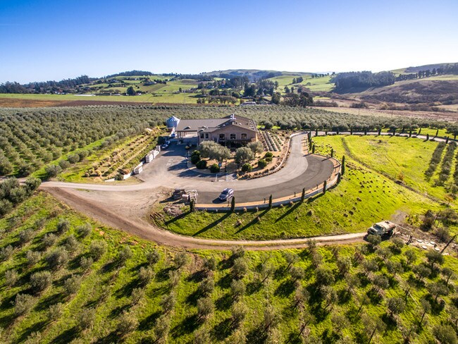

Property Detail
3387 Canfield Rd
025-070-038
2008 FM PTN 025-070-032 PCL 3 PM MNS 02-0008
Foodprocessing
Sonoma
B and X Area of moderate flood hazard, usually the area between the limits of the 100-year and 500-year floods.
California
2025
10.10 AC
2025
Sebastopol/Bodega
153501
North Bay/Santa Rosa
6,893 SF
Santa Rosa-Petaluma, CA
NEARBY LISTINGS FOR SALE OR LEASE
DEMOGRAPHICS near 3387 Canfield Rd
1 mile
3 mile
5 mile
2025 Total Population
466
6,790
25,125
2030 Population
428
6,244
24,165
Pop Growth 2025-2030
(8.15%)
(8.04%)
(3.82%)
Average Age
50
48
46
2025 Total Households
183
2,639
9,940
HH Growth 2025-2030
(8.20%)
(8.03%)
(3.79%)
Median Household Inc
$111,111
$106,512
$101,597
Avg Household Size
2.50
2.50
2.40
2025 Avg HH Vehicles
2.00
2.00
2.00
Median Home Value
$1,052,941
$1,031,654
$895,187
Median Year Built
1972
1972
1974
Nearby Places
Map Layers
Map Styles
 Street
 Aerial
Layers
 Traffic
 Biking
Places
Listings with unknown addresses are not visible on the map
- Restaurants
- Banks
- Shops
- Fitness
- Groceries
PUBLIC TRANSPORTATION
COMMUTER RAIL
Smart Rohnert Park (Main Line - Sonoma Marin Area Rail Transit)
Drive
Walk
Distance
Smart Rohnert Park (Main Line - Sonoma Marin Area Rail Transit)
21 min
8.2 mi
Smart Cotati (Main Line - Sonoma Marin Area Rail Transit)
Drive
Walk
Distance
Smart Cotati (Main Line - Sonoma Marin Area Rail Transit)
20 min
8.9 mi
AIRPORT
Charles M Schulz - Sonoma County
Drive
Walk
Distance
Charles M Schulz - Sonoma County
35 min
16.1 mi
Freight Ports
Port of Richmond
Drive
Walk
Distance
Port of Richmond
67 min
45.6 mi
SALE & LEASE HISTORY
LISTING DATE
SALE/LEASE

Oct 20, 2017
For Sale
Nearby Properties
Address
Land Use
TOTAL SIZE
Lot Size
Zoning
Address
Land Use
TOTAL SIZE
Lot Size
Zoning
104.12 AC
Address
Land Use
TOTAL SIZE
Lot Size
Zoning
1,156 SF
21.15 AC
Address
Land Use
TOTAL SIZE
Lot Size
Zoning
1,220 SF
493.74 AC
Address
Land Use
TOTAL SIZE
Lot Size
Zoning
1,876 SF
8.50 AC
Address
Land Use
TOTAL SIZE
Lot Size
Zoning
16,316 SF
3.33 AC
M3
Address
Land Use
TOTAL SIZE
Lot Size
Zoning
43,858 SF
2.35 AC
Address
Land Use
TOTAL SIZE
Lot Size
Zoning
1,048 SF
39 AC
DA20
Address
Land Use
TOTAL SIZE
Lot Size
Zoning
44.46 AC
DA10
Address
Land Use
TOTAL SIZE
Lot Size
Zoning
10,557 SF
128.76 AC
Address
Land Use
TOTAL SIZE
Lot Size
Zoning
2,576 SF
11.34 AC
RR2
Address
Land Use
TOTAL SIZE
Lot Size
Zoning
6,671 SF
2.96 AC
RR3
Address
Land Use
TOTAL SIZE
Lot Size
Zoning
14,404 SF
5 AC
M3
Address
Land Use
TOTAL SIZE
Lot Size
Zoning
576 SF
8 AC
DA10
Address
Land Use
TOTAL SIZE
Lot Size
Zoning
3,995 SF
8.23 AC
Address
Land Use
TOTAL SIZE
Lot Size
Zoning
5,202 SF
72 AC
LEA160
Address
Land Use
TOTAL SIZE
Lot Size
Zoning
2,331 SF
18.13 AC
Address
Land Use
TOTAL SIZE
Lot Size
Zoning
1,126 SF
2.91 AC
AR10
Address
Land Use
TOTAL SIZE
Lot Size
Zoning
75.82 AC
Address
Land Use
TOTAL SIZE
Lot Size
Zoning
2,733 SF
12.27 AC
DA20
Address
Land Use
TOTAL SIZE
Lot Size
Zoning
3,723 SF
0.14 AC
Address
Land Use
TOTAL SIZE
Lot Size
Zoning
2,856 SF
12.76 AC
Address
Land Use
TOTAL SIZE
Lot Size
Zoning
5,618 SF
23.86 AC
DA10
Address
Land Use
TOTAL SIZE
Lot Size
Zoning
2,104 SF
6.37 AC
AR4
Address
Land Use
TOTAL SIZE
Lot Size
Zoning
800 SF
11.86 AC
DA20
Address
Land Use
TOTAL SIZE
Lot Size
Zoning
2,688 SF
14.50 AC
Address
Land Use
TOTAL SIZE
Lot Size
Zoning
1,418 SF
19 AC
DA20
Address
Land Use
TOTAL SIZE
Lot Size
Zoning
4,089 SF
10.40 AC
Address
Land Use
TOTAL SIZE
Lot Size
Zoning
2,206 SF
15 AC
DA20
Address
Land Use
TOTAL SIZE
Lot Size
Zoning
2,500 SF
4.75 AC
DA10
The World's #1 Commercial Real Estate Marketplace
Connect with us
© 2026 CoStar Group
The information above has been obtained from sources believed reliable. While we do not doubt its accuracy we have not verified it and make no guarantee, warranty or representation about it. It is your responsibility to independently confirm its accuracy and completeness. Any projections, opinions, assumptions, or estimates used are for example only and do not represent the current or future performance of the property. The value of this transaction to you depends on tax and other factors which should be evaluated by your tax, financial, and legal advisors. You and your advisors should conduct a careful, independent investigation of the property to determine to your satisfaction the suitability of the property for your needs.