Property Record
339 7 Bridge Rd, Lancaster, MA 01523


Save to a Folder
{{folder.Name}}
{{folder.ListingIds.length}} Properties
{{folder.ListingIds.length}} Property
Create a New Folder
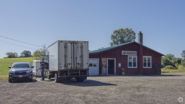
Property Detail
339 7 Bridge Rd
Worcester, MA
Worcester
LANC-000300-000000-001280
Massachusetts
Storebuilding
128.0
2025
20.17 AC
2025
Outlying Worcester
713100
Boston
4,032 SF
NEARBY LISTINGS FOR SALE OR LEASE
-
-
View all Lancaster listings for sale on LoopNet.com
DEMOGRAPHICS near 339 7 Bridge Rd
1 mile
3 mile
5 mile
2025 Total Population
945
12,202
41,282
2030 Population
966
12,478
42,434
Pop Growth 2025-2030
+ 2.22%
+ 2.26%
+ 2.79%
Average Age
41
43
42
2025 Total Households
331
4,509
15,703
HH Growth 2025-2030
+ 2.11%
+ 2.26%
+ 2.87%
Median Household Inc
$116,543
$119,432
$111,667
Avg Household Size
2.70
2.60
2.50
2025 Avg HH Vehicles
2.00
2.00
2.00
Median Home Value
$543,919
$507,256
$477,029
Median Year Built
1961
1971
1970
Nearby Places
Map Layers
Map Styles
 Street
 Aerial
Layers
 Traffic
 Biking
Places
Listings with unknown addresses are not visible on the map
- Restaurants
- Banks
- Shops
- Fitness
- Groceries
PUBLIC TRANSPORTATION
COMMUTER RAIL
North Leominster (Fitchburg/South Acton Line - Massachusetts Bay Transportation Authority Commuter Rail (Purple Line))
Drive
Walk
Distance
North Leominster (Fitchburg/South Acton Line - Massachusetts Bay Transportation Authority Commuter Rail (Purple Line))
13 min
7.6 mi
Shirley (Fitchburg/South Acton Line - Massachusetts Bay Transportation Authority Commuter Rail (Purple Line))
Drive
Walk
Distance
Shirley (Fitchburg/South Acton Line - Massachusetts Bay Transportation Authority Commuter Rail (Purple Line))
16 min
8.7 mi
AIRPORT
Worcester Regional
Drive
Walk
Distance
Worcester Regional
41 min
26.9 mi
Manchester Boston Regional
Drive
Walk
Distance
Manchester Boston Regional
70 min
48.2 mi
General Edward Lawrence Logan International
Drive
Walk
Distance
General Edward Lawrence Logan International
65 min
48.7 mi
Freight Ports
Port of Boston
Drive
Walk
Distance
Port of Boston
64 min
47.0 mi
SALE & LEASE HISTORY
LISTING DATE
SALE/LEASE

Feb 15, 2021
For Sale
Nearby Properties
Address
Land Use
TOTAL SIZE
Lot Size
Zoning
Address
Land Use
TOTAL SIZE
Lot Size
Zoning
344,000 SF
20.63 AC
Address
Land Use
TOTAL SIZE
Lot Size
Zoning
455,636 SF
54.47 AC
Address
Land Use
TOTAL SIZE
Lot Size
Zoning
85,557 SF
9.27 AC
Address
Land Use
TOTAL SIZE
Lot Size
Zoning
147,092 SF
36.90 AC
Address
Land Use
TOTAL SIZE
Lot Size
Zoning
158,900 SF
80 AC
Address
Land Use
TOTAL SIZE
Lot Size
Zoning
116,116 SF
53.90 AC
Address
Land Use
TOTAL SIZE
Lot Size
Zoning
133,068 SF
9 AC
Address
Land Use
TOTAL SIZE
Lot Size
Zoning
1.61 AC
Address
Land Use
TOTAL SIZE
Lot Size
Zoning
884 SF
59.40 AC
R1
Address
Land Use
TOTAL SIZE
Lot Size
Zoning
33,050 SF
7.80 AC
Address
Land Use
TOTAL SIZE
Lot Size
Zoning
70,516 SF
23 AC
Address
Land Use
TOTAL SIZE
Lot Size
Zoning
12.66 AC
Address
Land Use
TOTAL SIZE
Lot Size
Zoning
201,446 SF
47.61 AC
R1
Address
Land Use
TOTAL SIZE
Lot Size
Zoning
7.40 AC
Address
Land Use
TOTAL SIZE
Lot Size
Zoning
46,378 SF
3.80 AC
Address
Land Use
TOTAL SIZE
Lot Size
Zoning
90,848 SF
7 AC
Address
Land Use
TOTAL SIZE
Lot Size
Zoning
13,242 SF
1.96 AC
Address
Land Use
TOTAL SIZE
Lot Size
Zoning
32,022 SF
18.09 AC
Address
Land Use
TOTAL SIZE
Lot Size
Zoning
22,196 SF
101.91 AC
R1
Address
Land Use
TOTAL SIZE
Lot Size
Zoning
9.18 AC
Address
Land Use
TOTAL SIZE
Lot Size
Zoning
2,576 SF
1.20 AC
Address
Land Use
TOTAL SIZE
Lot Size
Zoning
10,000 SF
2 AC
Address
Land Use
TOTAL SIZE
Lot Size
Zoning
36,498 SF
1.90 AC
Address
Land Use
TOTAL SIZE
Lot Size
Zoning
57,942 SF
0.50 AC
Address
Land Use
TOTAL SIZE
Lot Size
Zoning
15,808 SF
1.64 AC
Address
Land Use
TOTAL SIZE
Lot Size
Zoning
1.86 AC
Address
Land Use
TOTAL SIZE
Lot Size
Zoning
12,020 SF
2.40 AC
Address
Land Use
TOTAL SIZE
Lot Size
Zoning
2.63 AC
Address
Land Use
TOTAL SIZE
Lot Size
Zoning
2.14 AC
Address
Land Use
TOTAL SIZE
Lot Size
Zoning
2,240 SF
1.06 AC
The World's #1 Commercial Real Estate Marketplace
Connect with us
© 2026 CoStar Group
The information above has been obtained from sources believed reliable. While we do not doubt its accuracy we have not verified it and make no guarantee, warranty or representation about it. It is your responsibility to independently confirm its accuracy and completeness. Any projections, opinions, assumptions, or estimates used are for example only and do not represent the current or future performance of the property. The value of this transaction to you depends on tax and other factors which should be evaluated by your tax, financial, and legal advisors. You and your advisors should conduct a careful, independent investigation of the property to determine to your satisfaction the suitability of the property for your needs.