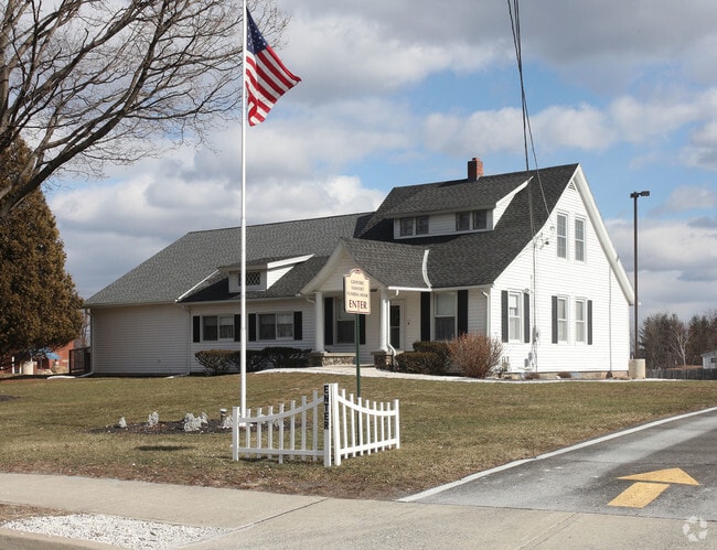
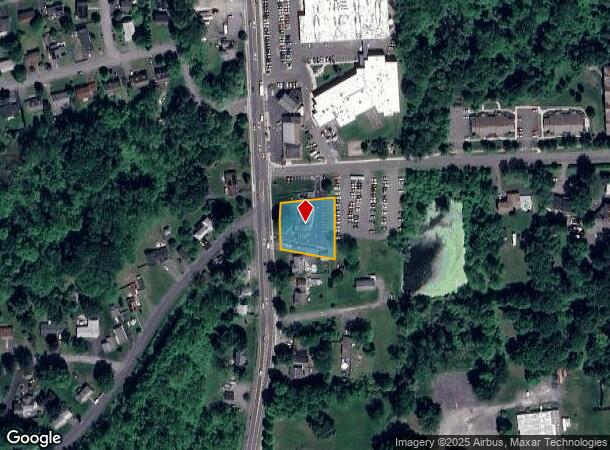
Property Record
339 Broadway, Ulster Park, NY 12487
NEARBY LISTINGS FOR SALE OR LEASE
Property Detail
339 Broadway
Funeralhome
Ulster
X
New York
36111C0490E
33.000
2025
0.68 AC
2024
Other Market Areas
952600
Kingston, NY
2,732 SF
2200-056.076-0002-033.000-0000
DEMOGRAPHICS near 339 Broadway
1 Mile
3 Mile
5 Mile
2024 Total Population
2,400
17,641
46,636
2029 Population
2,307
17,407
46,386
Pop Growth 2024-2029
(3.88%)
(1.33%)
(0.54%)
Average Age
45
42
44
2024 Total Households
1,003
7,264
19,996
HH Growth 2024-2029
(4.09%)
(1.45%)
(0.55%)
Median Household Inc
$69,535
$69,676
$73,349
Avg Household Size
2.20
2.20
2.10
2024 Avg HH Vehicles
2.00
2.00
2.00
Median Home Value
$246,153
$236,088
$279,985
Median Year Built
1974
1952
1956
Nearby Places
- Restaurants
- Banks
- Shops
- Fitness
- Groceries
PUBLIC TRANSPORTATION
AIRPORT
New York Stewart International
DRIVE
WALK
Distance
New York Stewart International
47 min
34.6 mi
Freight Ports
Albany, NY Port
DRIVE
WALK
Distance
Albany, NY Port
71 min
56.1 mi
Nearby Properties
Address
Land Use
TOTAL SIZE
Lot Size
Zoning
Address
Land Use
TOTAL SIZE
Lot Size
Zoning
21.40 AC
R-1
Address
Land Use
TOTAL SIZE
Lot Size
Zoning
1.58 AC
T5F
Address
Land Use
TOTAL SIZE
Lot Size
Zoning
240,924 SF
17 AC
SD
Address
Land Use
TOTAL SIZE
Lot Size
Zoning
181,151 SF
4.90 AC
SD
Address
Land Use
TOTAL SIZE
Lot Size
Zoning
250,613 SF
11.70 AC
SD
Address
Land Use
TOTAL SIZE
Lot Size
Zoning
71,781 SF
6.50 AC
R40
Address
Land Use
TOTAL SIZE
Lot Size
Zoning
32,044 SF
51.24 AC
HP20
Address
Land Use
TOTAL SIZE
Lot Size
Zoning
143,271 SF
20.40 AC
SD
Address
Land Use
TOTAL SIZE
Lot Size
Zoning
172.24 AC
HP20
Address
Land Use
TOTAL SIZE
Lot Size
Zoning
67,180 SF
2.60 AC
T5MS
Address
Land Use
TOTAL SIZE
Lot Size
Zoning
53,605 SF
10.83 AC
T5N
Address
Land Use
TOTAL SIZE
Lot Size
Zoning
88,000 SF
6.90 AC
GC
Address
Land Use
TOTAL SIZE
Lot Size
Zoning
133,760 SF
31.25 AC
LI
Address
Land Use
TOTAL SIZE
Lot Size
Zoning
10,581 SF
37.69 AC
HP20
Address
Land Use
TOTAL SIZE
Lot Size
Zoning
67,566 SF
2.90 AC
T5N
Address
Land Use
TOTAL SIZE
Lot Size
Zoning
76,577 SF
1.30 AC
T5F
Address
Land Use
TOTAL SIZE
Lot Size
Zoning
4,104 SF
14.38 AC
SD
Address
Land Use
TOTAL SIZE
Lot Size
Zoning
64,597 SF
200.40 AC
R40
Address
Land Use
TOTAL SIZE
Lot Size
Zoning
28,774 SF
9.11 AC
PUD
Address
Land Use
TOTAL SIZE
Lot Size
Zoning
32,934 SF
3 AC
R40
Address
Land Use
TOTAL SIZE
Lot Size
Zoning
2,670 SF
20.90 AC
SD
Address
Land Use
TOTAL SIZE
Lot Size
Zoning
11,488 SF
10.80 AC
SD
Address
Land Use
TOTAL SIZE
Lot Size
Zoning
50,350 SF
3.70 AC
SD
Address
Land Use
TOTAL SIZE
Lot Size
Zoning
9,359 SF
112.03 AC
RC5
Address
Land Use
TOTAL SIZE
Lot Size
Zoning
8,400 SF
9 AC
SD
Address
Land Use
TOTAL SIZE
Lot Size
Zoning
9,167 SF
34.20 AC
HP20
Address
Land Use
TOTAL SIZE
Lot Size
Zoning
31,598 SF
40.24 AC
RA10
Address
Land Use
TOTAL SIZE
Lot Size
Zoning
8,924 SF
10.66 AC
RC5
Address
Land Use
TOTAL SIZE
Lot Size
Zoning
902 SF
538.31 AC
RA10
Address
Land Use
TOTAL SIZE
Lot Size
Zoning
68 AC
RRR
The World's #1 Commercial Real Estate Marketplace
Connect with us
© 2025 CoStar Group
The information above has been obtained from sources believed reliable. While we do not doubt its accuracy we have not verified it and make no guarantee, warranty or representation about it. It is your responsibility to independently confirm its accuracy and completeness. Any projections, opinions, assumptions, or estimates used are for example only and do not represent the current or future performance of the property. The value of this transaction to you depends on tax and other factors which should be evaluated by your tax, financial, and legal advisors. You and your advisors should conduct a careful, independent investigation of the property to determine to your satisfaction the suitability of the property for your needs.