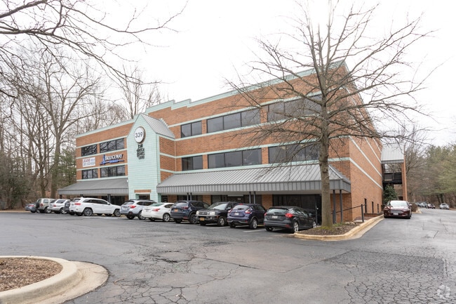
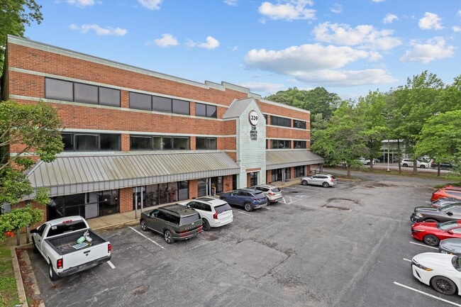
Property Record
339 Buschs Frontage Rd, Annapolis, MD 21409


This Property Is For Sale
Current Lease Availabilities
NEARBY LISTINGS FOR SALE OR LEASE
Property Detail
339 Buschs Frontage Rd
03-000-00440305
St Margarets
Officebuilding
2.567 ACRES ST MARGARETS
X
Anne Arundel
24003C0189F
Maryland
2024
2.56 AC
2025
Annapolis
730902
Baltimore
32,316 SF
Baltimore-Columbia-Towson, MD
DEMOGRAPHICS near 339 Buschs Frontage Rd
1 Mile
3 Mile
5 Mile
2024 Total Population
4,955
34,896
78,778
2029 Population
5,029
35,691
80,899
Pop Growth 2024-2029
+ 1.49%
+ 2.28%
+ 2.69%
Average Age
41
41
42
2024 Total Households
1,856
12,618
31,014
HH Growth 2024-2029
+ 1.45%
+ 2.29%
+ 2.82%
Median Household Inc
$123,722
$136,316
$127,792
Avg Household Size
2.60
2.70
2.50
2024 Avg HH Vehicles
2.00
2.00
2.00
Median Home Value
$458,068
$502,360
$544,229
Median Year Built
1982
1981
1977
Nearby Places
Map Layers
Map Styles
 Street
 Aerial
- Restaurants
- Banks
- Shops
- Fitness
- Groceries
PUBLIC TRANSPORTATION
AIRPORT
Baltimore/Washington International Thurgood Marshall
DRIVE
WALK
Distance
Baltimore/Washington International Thurgood Marshall
37 min
21.8 mi
Ronald Reagan Washington Ntl
DRIVE
WALK
Distance
Ronald Reagan Washington Ntl
55 min
39.6 mi
Freight Ports
Port of Baltimore
DRIVE
WALK
Distance
Port of Baltimore
43 min
27.1 mi
Nearby Properties
Address
Land Use
TOTAL SIZE
Lot Size
Zoning
Address
Land Use
TOTAL SIZE
Lot Size
Zoning
434,112 SF
822.11 AC
R1
Address
Land Use
TOTAL SIZE
Lot Size
Zoning
318,622 SF
62.01 AC
R5
Address
Land Use
TOTAL SIZE
Lot Size
Zoning
100,236 SF
12.99 AC
R5
Address
Land Use
TOTAL SIZE
Lot Size
Zoning
232,695 SF
32.96 AC
W1
Address
Land Use
TOTAL SIZE
Lot Size
Zoning
5.62 AC
R15
Address
Land Use
TOTAL SIZE
Lot Size
Zoning
7.56 AC
R15
Address
Land Use
TOTAL SIZE
Lot Size
Zoning
88,832 SF
8.09 AC
C3
Address
Land Use
TOTAL SIZE
Lot Size
Zoning
6,182 SF
33.74 AC
OS
Address
Land Use
TOTAL SIZE
Lot Size
Zoning
44,680 SF
3.54 AC
C3
Address
Land Use
TOTAL SIZE
Lot Size
Zoning
60,971 SF
5.04 AC
C3
Address
Land Use
TOTAL SIZE
Lot Size
Zoning
9.90 AC
R15
Address
Land Use
TOTAL SIZE
Lot Size
Zoning
45,200 SF
3.28 AC
C4
Address
Land Use
TOTAL SIZE
Lot Size
Zoning
74,540 SF
53.76 AC
R5
Address
Land Use
TOTAL SIZE
Lot Size
Zoning
51,294 SF
29.29 AC
R5
Address
Land Use
TOTAL SIZE
Lot Size
Zoning
30,153 SF
7.05 AC
C4
Address
Land Use
TOTAL SIZE
Lot Size
Zoning
56,370 SF
6.53 AC
C4
Address
Land Use
TOTAL SIZE
Lot Size
Zoning
53,843 SF
7.24 AC
C3
Address
Land Use
TOTAL SIZE
Lot Size
Zoning
81,496 SF
3.89 AC
C4
Address
Land Use
TOTAL SIZE
Lot Size
Zoning
39,718 SF
12.73 AC
RLD
Address
Land Use
TOTAL SIZE
Lot Size
Zoning
128,988 SF
5.43 AC
C2
Address
Land Use
TOTAL SIZE
Lot Size
Zoning
37,860 SF
2.96 AC
C4
Address
Land Use
TOTAL SIZE
Lot Size
Zoning
24.78 AC
R1
Address
Land Use
TOTAL SIZE
Lot Size
Zoning
20,048 SF
1.98 AC
C4
Address
Land Use
TOTAL SIZE
Lot Size
Zoning
46.71 AC
R1
Address
Land Use
TOTAL SIZE
Lot Size
Zoning
82,389 SF
7.71 AC
C4
Address
Land Use
TOTAL SIZE
Lot Size
Zoning
26,496 SF
5.80 AC
R1
Address
Land Use
TOTAL SIZE
Lot Size
Zoning
21,108 SF
2.82 AC
C4
Address
Land Use
TOTAL SIZE
Lot Size
Zoning
53,290 SF
10 AC
R1
Address
Land Use
TOTAL SIZE
Lot Size
Zoning
13,367 SF
6.27 AC
C3
The World's #1 Commercial Real Estate Marketplace
Connect with us
© 2026 CoStar Group
The information above has been obtained from sources believed reliable. While we do not doubt its accuracy we have not verified it and make no guarantee, warranty or representation about it. It is your responsibility to independently confirm its accuracy and completeness. Any projections, opinions, assumptions, or estimates used are for example only and do not represent the current or future performance of the property. The value of this transaction to you depends on tax and other factors which should be evaluated by your tax, financial, and legal advisors. You and your advisors should conduct a careful, independent investigation of the property to determine to your satisfaction the suitability of the property for your needs.