Property Record
12 Welchville Commons Dr, Oxford, ME 04270

NEARBY LISTINGS FOR SALE OR LEASE
-
-
View all Oxford listings for sale on LoopNet.com
Property Detail
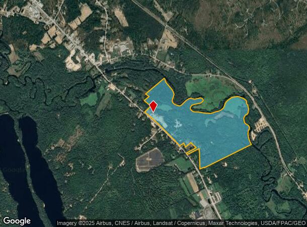
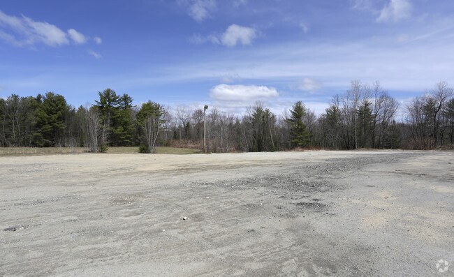
12 Welchville Commons Dr
OXRD-000000-R000002-000001
Oxford
Residentialacreage
Maine
X
1
23001C0175E
2.01 AC
2024
Maine South & Augusta
2024
Other Market Areas
966402
DEMOGRAPHICS near 12 Welchville Commons Dr
1 Mile
3 Mile
5 Mile
2024 Total Population
307
3,630
9,382
2029 Population
331
3,882
9,833
Pop Growth 2024-2029
+ 7.82%
+ 6.94%
+ 4.81%
Average Age
43
43
43
2024 Total Households
122
1,472
3,779
HH Growth 2024-2029
+ 7.38%
+ 6.66%
+ 4.74%
Median Household Inc
$54,285
$64,643
$67,291
Avg Household Size
2.50
2.40
2.40
2024 Avg HH Vehicles
2.00
2.00
2.00
Median Home Value
$141,216
$172,616
$189,103
Median Year Built
1980
1984
1985
Nearby Places
Map Layers
Map Styles
 Street
 Aerial
- Restaurants
- Banks
- Shops
- Fitness
- Groceries
SALE & LEASE HISTORY
LISTING DATE
SALE/LEASE

Sep 24, 2016
For Sale
Nearby Properties
Address
Land Use
TOTAL SIZE
Lot Size
Zoning
Address
Land Use
TOTAL SIZE
Lot Size
Zoning
146,077 SF
96.50 AC
3
Address
Land Use
TOTAL SIZE
Lot Size
Zoning
Address
Land Use
TOTAL SIZE
Lot Size
Zoning
44,500 SF
4.31 AC
4
Address
Land Use
TOTAL SIZE
Lot Size
Zoning
Address
Land Use
TOTAL SIZE
Lot Size
Zoning
59,514 SF
6 AC
4
Address
Land Use
TOTAL SIZE
Lot Size
Zoning
59,514 SF
6 AC
4
Address
Land Use
TOTAL SIZE
Lot Size
Zoning
63,388 SF
14.84 AC
1
Address
Land Use
TOTAL SIZE
Lot Size
Zoning
37,164 SF
64 AC
4
Address
Land Use
TOTAL SIZE
Lot Size
Zoning
91,917 SF
24 AC
1
Address
Land Use
TOTAL SIZE
Lot Size
Zoning
Address
Land Use
TOTAL SIZE
Lot Size
Zoning
3,200 SF
40 AC
3
Address
Land Use
TOTAL SIZE
Lot Size
Zoning
3,200 SF
40 AC
3
Address
Land Use
TOTAL SIZE
Lot Size
Zoning
30,710 SF
4.47 AC
2 MILL
Address
Land Use
TOTAL SIZE
Lot Size
Zoning
86,106 SF
12 AC
3
Address
Land Use
TOTAL SIZE
Lot Size
Zoning
86,106 SF
12 AC
3
Address
Land Use
TOTAL SIZE
Lot Size
Zoning
30,710 SF
4.47 AC
2 MILL
Address
Land Use
TOTAL SIZE
Lot Size
Zoning
5,340 SF
0.66 AC
6
Address
Land Use
TOTAL SIZE
Lot Size
Zoning
29,600 SF
3.20 AC
3
Address
Land Use
TOTAL SIZE
Lot Size
Zoning
17,016 SF
4.69 AC
3
Address
Land Use
TOTAL SIZE
Lot Size
Zoning
17,016 SF
4.69 AC
3
Address
Land Use
TOTAL SIZE
Lot Size
Zoning
25,894 SF
2.86 AC
6
Address
Land Use
TOTAL SIZE
Lot Size
Zoning
89 AC
4
Address
Land Use
TOTAL SIZE
Lot Size
Zoning
7,129 SF
5.80 AC
3
Address
Land Use
TOTAL SIZE
Lot Size
Zoning
7,129 SF
5.80 AC
3
Address
Land Use
TOTAL SIZE
Lot Size
Zoning
54,210 SF
10.67 AC
Address
Land Use
TOTAL SIZE
Lot Size
Zoning
15,800 SF
15.74 AC
3
Address
Land Use
TOTAL SIZE
Lot Size
Zoning
8,218 SF
7.50 AC
4
Address
Land Use
TOTAL SIZE
Lot Size
Zoning
6,120 SF
4 AC
6
Address
Land Use
TOTAL SIZE
Lot Size
Zoning
6,120 SF
4 AC
6
Address
Land Use
TOTAL SIZE
Lot Size
Zoning
14,000 SF
2.38 AC
The World's #1 Commercial Real Estate Marketplace
Connect with us
© 2025 CoStar Group
The information above has been obtained from sources believed reliable. While we do not doubt its accuracy we have not verified it and make no guarantee, warranty or representation about it. It is your responsibility to independently confirm its accuracy and completeness. Any projections, opinions, assumptions, or estimates used are for example only and do not represent the current or future performance of the property. The value of this transaction to you depends on tax and other factors which should be evaluated by your tax, financial, and legal advisors. You and your advisors should conduct a careful, independent investigation of the property to determine to your satisfaction the suitability of the property for your needs.