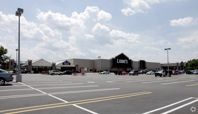
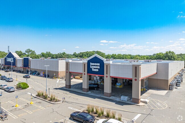
Property Record
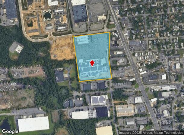
339 State Route 18, East Brunswick, NJ 08816
NEARBY LISTINGS FOR SALE OR LEASE
Property Detail
339 State Route 18
New York-Jersey City-White Plains, NY-NJ
Incl
04-00032-0000-00002-10
13.9000
Storebuilding
Middlesex
X
New Jersey
34023C0134F
2.10
2024
13.90 AC
2025
Brunswick
009400
Northern New Jersey
166,717 SF
DEMOGRAPHICS near 339 State Route 18
1 Mile
3 Mile
5 Mile
2024 Total Population
12,150
83,861
258,068
2029 Population
12,129
83,511
256,312
Pop Growth 2024-2029
(0.17%)
(0.42%)
(0.68%)
Average Age
40
40
38
2024 Total Households
4,502
29,037
87,739
HH Growth 2024-2029
(0.13%)
(0.42%)
(0.61%)
Median Household Inc
$92,523
$105,889
$92,533
Avg Household Size
2.60
2.80
2.80
2024 Avg HH Vehicles
2.00
2.00
2.00
Median Home Value
$352,574
$413,822
$389,463
Median Year Built
1965
1966
1968
Nearby Places
Map Layers
Map Styles
 Street
 Aerial
- Restaurants
- Banks
- Shops
- Fitness
- Groceries
PUBLIC TRANSPORTATION
COMMUTER RAIL
New Brunswick (Northeast Corridor Line - NJ Transit Commuter Rail (NJ Transit))
DRIVE
WALK
Distance
New Brunswick (Northeast Corridor Line - NJ Transit Commuter Rail (NJ Transit))
9 min
4.9 mi
Jersey Avenue (Northeast Corridor Line - NJ Transit Commuter Rail (NJ Transit))
DRIVE
WALK
Distance
Jersey Avenue (Northeast Corridor Line - NJ Transit Commuter Rail (NJ Transit))
17 min
6.9 mi
AIRPORT
Newark Liberty International
DRIVE
WALK
Distance
Newark Liberty International
37 min
27.0 mi
Trenton Mercer
DRIVE
WALK
Distance
Trenton Mercer
47 min
32.2 mi
Freight Ports
New York Container Terminal
DRIVE
WALK
Distance
New York Container Terminal
30 min
22.1 mi
Nearby Properties
Address
Land Use
TOTAL SIZE
Lot Size
Zoning
Address
Land Use
TOTAL SIZE
Lot Size
Zoning
38,536 SF
149.61 AC
IN-2
Address
Land Use
TOTAL SIZE
Lot Size
Zoning
37.80 AC
IN-2
Address
Land Use
TOTAL SIZE
Lot Size
Zoning
77.04 AC
I2
Address
Land Use
TOTAL SIZE
Lot Size
Zoning
5.54 AC
C-5
Address
Land Use
TOTAL SIZE
Lot Size
Zoning
81,600 SF
49.89 AC
LI
Address
Land Use
TOTAL SIZE
Lot Size
Zoning
Address
Land Use
TOTAL SIZE
Lot Size
Zoning
4,600 SF
33.13 AC
IN-2
Address
Land Use
TOTAL SIZE
Lot Size
Zoning
182.24 AC
ERR
Address
Land Use
TOTAL SIZE
Lot Size
Zoning
12,800 SF
17.08 AC
R-6
Address
Land Use
TOTAL SIZE
Lot Size
Zoning
4,678 SF
3.79 AC
IN-2
Address
Land Use
TOTAL SIZE
Lot Size
Zoning
8,280 SF
1.12 AC
R-6
Address
Land Use
TOTAL SIZE
Lot Size
Zoning
2,400 SF
124.08 AC
ERR
Address
Land Use
TOTAL SIZE
Lot Size
Zoning
23.02 AC
IN-2
Address
Land Use
TOTAL SIZE
Lot Size
Zoning
46.33 AC
I2
Address
Land Use
TOTAL SIZE
Lot Size
Zoning
24.19 AC
R100
Address
Land Use
TOTAL SIZE
Lot Size
Zoning
2,520 SF
2.46 AC
IN-2
Address
Land Use
TOTAL SIZE
Lot Size
Zoning
315,200 SF
22.76 AC
LI
Address
Land Use
TOTAL SIZE
Lot Size
Zoning
7.41 AC
MXD
Address
Land Use
TOTAL SIZE
Lot Size
Zoning
63.43 AC
ERR
Address
Land Use
TOTAL SIZE
Lot Size
Zoning
Address
Land Use
TOTAL SIZE
Lot Size
Zoning
2,349 SF
11.29 AC
IN-2
Address
Land Use
TOTAL SIZE
Lot Size
Zoning
27,498 SF
87.15 AC
ERR
Address
Land Use
TOTAL SIZE
Lot Size
Zoning
20.01 AC
C2
Address
Land Use
TOTAL SIZE
Lot Size
Zoning
245,980 SF
54.02 AC
OP1
Address
Land Use
TOTAL SIZE
Lot Size
Zoning
9.08 AC
R-6
Address
Land Use
TOTAL SIZE
Lot Size
Zoning
367,200 SF
34.22 AC
HC2
Address
Land Use
TOTAL SIZE
Lot Size
Zoning
14.34 AC
R100
Address
Land Use
TOTAL SIZE
Lot Size
Zoning
9.67 AC
ERR
Address
Land Use
TOTAL SIZE
Lot Size
Zoning
14.19 AC
C-5
Address
Land Use
TOTAL SIZE
Lot Size
Zoning
4.58 AC
H1
The World's #1 Commercial Real Estate Marketplace
Connect with us
© 2025 CoStar Group
The information above has been obtained from sources believed reliable. While we do not doubt its accuracy we have not verified it and make no guarantee, warranty or representation about it. It is your responsibility to independently confirm its accuracy and completeness. Any projections, opinions, assumptions, or estimates used are for example only and do not represent the current or future performance of the property. The value of this transaction to you depends on tax and other factors which should be evaluated by your tax, financial, and legal advisors. You and your advisors should conduct a careful, independent investigation of the property to determine to your satisfaction the suitability of the property for your needs.