Property Record
339 W 2Nd St, East Syracuse, NY 13057

NEARBY LISTINGS FOR SALE OR LEASE
-
-
View all East Syracuse listings for sale on LoopNet.com
Property Detail
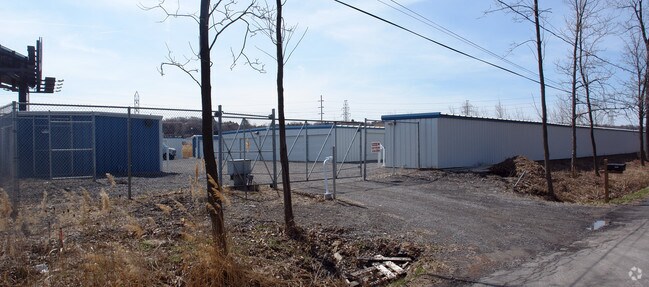
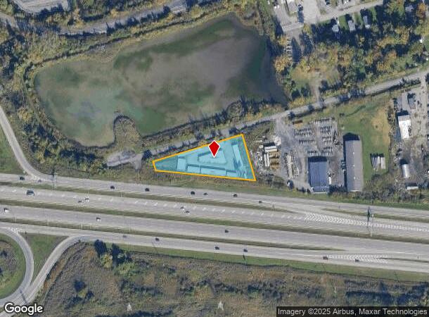
339 W 2Nd St
312601-009-000-0007-002-002-0000
Onondaga
Gasolinefuelbulkstorage
New York
AE
2.002
36067C0237F
1 AC
2025
SE Outer Onondaga County
2024
Syracuse
014300
Syracuse, NY
1,953 SF
DEMOGRAPHICS near 339 W 2Nd St
1 Mile
3 Mile
5 Mile
2024 Total Population
8,854
74,384
180,086
2029 Population
8,641
72,444
176,477
Pop Growth 2024-2029
(2.41%)
(2.61%)
(2.00%)
Average Age
38
38
38
2024 Total Households
3,802
30,025
72,924
HH Growth 2024-2029
(2.39%)
(2.82%)
(2.04%)
Median Household Inc
$55,526
$57,928
$48,565
Avg Household Size
2.10
2.20
2.20
2024 Avg HH Vehicles
1.00
1.00
1.00
Median Home Value
$126,296
$160,880
$152,245
Median Year Built
1955
1953
1953
Nearby Places
- Restaurants
- Banks
- Shops
- Fitness
- Groceries
PUBLIC TRANSPORTATION
COMMUTER RAIL
Syracuse Regional Transportation Center (Empire Service - Amtrak, Lake Shore Limited - Amtrak, Maple Leaf - Amtrak)
DRIVE
WALK
Distance
Syracuse Regional Transportation Center (Empire Service - Amtrak, Lake Shore Limited - Amtrak, Maple Leaf - Amtrak)
13 min
7.4 mi
Syracuse (Toronto - New York - VIA Rail)
DRIVE
WALK
Distance
Syracuse (Toronto - New York - VIA Rail)
14 min
7.4 mi
AIRPORT
Syracuse Hancock International
DRIVE
WALK
Distance
Syracuse Hancock International
20 min
12.0 mi
Freight Ports
Albany, NY Port
DRIVE
WALK
Distance
Albany, NY Port
173 min
143.5 mi
Nearby Properties
Address
Land Use
TOTAL SIZE
Lot Size
Zoning
Address
Land Use
TOTAL SIZE
Lot Size
Zoning
354,492 SF
6.90 AC
25
Address
Land Use
TOTAL SIZE
Lot Size
Zoning
409,062 SF
10
Address
Land Use
TOTAL SIZE
Lot Size
Zoning
38,693 SF
102.34 AC
05 - COMME
Address
Land Use
TOTAL SIZE
Lot Size
Zoning
2,709 SF
39.74 AC
06 - INDUS
Address
Land Use
TOTAL SIZE
Lot Size
Zoning
165,800 SF
1.27 AC
25
Address
Land Use
TOTAL SIZE
Lot Size
Zoning
105,004 SF
2.81 AC
25
Address
Land Use
TOTAL SIZE
Lot Size
Zoning
569,463 SF
94.77 AC
06 - INDUS
Address
Land Use
TOTAL SIZE
Lot Size
Zoning
12,836 SF
148.95 AC
06 - INDUS
Address
Land Use
TOTAL SIZE
Lot Size
Zoning
278,208 SF
1.92 AC
25
Address
Land Use
TOTAL SIZE
Lot Size
Zoning
876,645 SF
51.07 AC
05 - COMME
Address
Land Use
TOTAL SIZE
Lot Size
Zoning
217,709 SF
34.53 AC
01 - NOT Z
Address
Land Use
TOTAL SIZE
Lot Size
Zoning
432,246 SF
37.21 AC
05 - COMME
Address
Land Use
TOTAL SIZE
Lot Size
Zoning
174,750 SF
10.40 AC
06 - INDUS
Address
Land Use
TOTAL SIZE
Lot Size
Zoning
104,400 SF
12.84 AC
06 - INDUS
Address
Land Use
TOTAL SIZE
Lot Size
Zoning
17,388 SF
26.51 AC
07 - MIXED
Address
Land Use
TOTAL SIZE
Lot Size
Zoning
102,905 SF
32 AC
01 - NOT Z
Address
Land Use
TOTAL SIZE
Lot Size
Zoning
115,000 SF
07 - MIXED
Address
Land Use
TOTAL SIZE
Lot Size
Zoning
157,497 SF
14.56 AC
06 - INDUS
Address
Land Use
TOTAL SIZE
Lot Size
Zoning
240,800 SF
23.01 AC
05 - COMME
Address
Land Use
TOTAL SIZE
Lot Size
Zoning
86,136 SF
0.80 AC
025
Address
Land Use
TOTAL SIZE
Lot Size
Zoning
40,684 SF
1.62 AC
08 - GOVER
Address
Land Use
TOTAL SIZE
Lot Size
Zoning
163,518 SF
19.24 AC
07 - MIXED
Address
Land Use
TOTAL SIZE
Lot Size
Zoning
47,122 SF
42.77 AC
06 - INDUS
Address
Land Use
TOTAL SIZE
Lot Size
Zoning
141,151 SF
20.23 AC
06 - INDUS
Address
Land Use
TOTAL SIZE
Lot Size
Zoning
102,883 SF
23.29 AC
02 - SINGL
Address
Land Use
TOTAL SIZE
Lot Size
Zoning
110,105 SF
26.68 AC
06 - INDUS
Address
Land Use
TOTAL SIZE
Lot Size
Zoning
95.24 AC
05 - COMME
Address
Land Use
TOTAL SIZE
Lot Size
Zoning
160,767 SF
20.52 AC
05 - COMME
Address
Land Use
TOTAL SIZE
Lot Size
Zoning
110,976 SF
42.31 AC
06 - INDUS
Address
Land Use
TOTAL SIZE
Lot Size
Zoning
165,954 SF
10.66 AC
06 - INDUS
The World's #1 Commercial Real Estate Marketplace
Connect with us
© 2025 CoStar Group
The information above has been obtained from sources believed reliable. While we do not doubt its accuracy we have not verified it and make no guarantee, warranty or representation about it. It is your responsibility to independently confirm its accuracy and completeness. Any projections, opinions, assumptions, or estimates used are for example only and do not represent the current or future performance of the property. The value of this transaction to you depends on tax and other factors which should be evaluated by your tax, financial, and legal advisors. You and your advisors should conduct a careful, independent investigation of the property to determine to your satisfaction the suitability of the property for your needs.