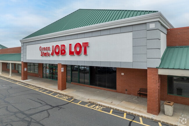
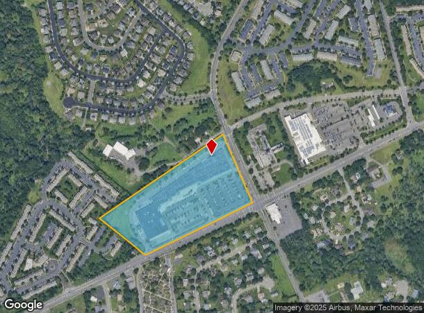
Property Record
3391 Rt 27, Franklin, NJ 07416


Current Lease Availabilities
NEARBY LISTINGS FOR SALE OR LEASE
Property Detail
3391 Rt 27
08-00020-11-00014-01
Somerset
Regionalshoppingcenterormallwithanchorstore
New Jersey
X
14.1
34023C0112F
15 AC
2024
Princeton North
2025
Northern New Jersey
372900
Newark, NJ-PA
141,554 SF
DEMOGRAPHICS near 3391 Rt 27
1 Mile
3 Mile
5 Mile
2024 Total Population
12,714
47,465
116,714
2029 Population
12,678
47,369
116,385
Pop Growth 2024-2029
(0.28%)
(0.20%)
(0.28%)
Average Age
42
40
40
2024 Total Households
4,716
17,215
40,532
HH Growth 2024-2029
(0.36%)
(0.27%)
(0.36%)
Median Household Inc
$119,199
$117,287
$128,169
Avg Household Size
2.70
2.70
2.80
2024 Avg HH Vehicles
2.00
2.00
2.00
Median Home Value
$431,507
$476,939
$488,074
Median Year Built
1990
1987
1986
Nearby Places
Map Layers
Map Styles
 Street
 Aerial
- Restaurants
- Banks
- Shops
- Fitness
- Groceries
PUBLIC TRANSPORTATION
COMMUTER RAIL
Jersey Avenue (Northeast Corridor Line - NJ Transit Commuter Rail (NJ Transit))
DRIVE
WALK
Distance
Jersey Avenue (Northeast Corridor Line - NJ Transit Commuter Rail (NJ Transit))
16 min
6.8 mi
New Brunswick (Northeast Corridor Line - NJ Transit Commuter Rail (NJ Transit))
DRIVE
WALK
Distance
New Brunswick (Northeast Corridor Line - NJ Transit Commuter Rail (NJ Transit))
16 min
8.1 mi
AIRPORT
Trenton Mercer
DRIVE
WALK
Distance
Trenton Mercer
33 min
22.3 mi
Newark Liberty International
DRIVE
WALK
Distance
Newark Liberty International
48 min
35.9 mi
Freight Ports
New York Container Terminal
DRIVE
WALK
Distance
New York Container Terminal
42 min
28.7 mi
Nearby Properties
Address
Land Use
TOTAL SIZE
Lot Size
Zoning
Address
Land Use
TOTAL SIZE
Lot Size
Zoning
2,530 SF
20.05 AC
R10B
Address
Land Use
TOTAL SIZE
Lot Size
Zoning
34.75 AC
CR
Address
Land Use
TOTAL SIZE
Lot Size
Zoning
27.23 AC
CR
Address
Land Use
TOTAL SIZE
Lot Size
Zoning
419,094 SF
49.17 AC
CR
Address
Land Use
TOTAL SIZE
Lot Size
Zoning
2,676 SF
16.50 AC
CR
Address
Land Use
TOTAL SIZE
Lot Size
Zoning
95,064 SF
14.41 AC
CR
Address
Land Use
TOTAL SIZE
Lot Size
Zoning
192,072 SF
19.83 AC
CR
Address
Land Use
TOTAL SIZE
Lot Size
Zoning
97,470 SF
11 AC
NB
Address
Land Use
TOTAL SIZE
Lot Size
Zoning
28.96 AC
R10B
Address
Land Use
TOTAL SIZE
Lot Size
Zoning
27.47 AC
R5
Address
Land Use
TOTAL SIZE
Lot Size
Zoning
6.36 AC
R10B
Address
Land Use
TOTAL SIZE
Lot Size
Zoning
249 SF
19.46 AC
R6
Address
Land Use
TOTAL SIZE
Lot Size
Zoning
23.67 AC
I2
Address
Land Use
TOTAL SIZE
Lot Size
Zoning
Address
Land Use
TOTAL SIZE
Lot Size
Zoning
72,720 SF
8.99 AC
NB
Address
Land Use
TOTAL SIZE
Lot Size
Zoning
14.19 AC
CRM3
Address
Land Use
TOTAL SIZE
Lot Size
Zoning
152.47 AC
PL
Address
Land Use
TOTAL SIZE
Lot Size
Zoning
14.29 AC
TOD
Address
Land Use
TOTAL SIZE
Lot Size
Zoning
7.45 AC
R10B
Address
Land Use
TOTAL SIZE
Lot Size
Zoning
1,158 SF
5.01 AC
CR
Address
Land Use
TOTAL SIZE
Lot Size
Zoning
14.63 AC
RM-3
Address
Land Use
TOTAL SIZE
Lot Size
Zoning
13.81 AC
PL
Address
Land Use
TOTAL SIZE
Lot Size
Zoning
90.49 AC
PL
Address
Land Use
TOTAL SIZE
Lot Size
Zoning
18.51 AC
Address
Land Use
TOTAL SIZE
Lot Size
Zoning
21.66 AC
I2
Address
Land Use
TOTAL SIZE
Lot Size
Zoning
3.97 AC
NB
Address
Land Use
TOTAL SIZE
Lot Size
Zoning
17.75 AC
MF
Address
Land Use
TOTAL SIZE
Lot Size
Zoning
12 AC
PL
Address
Land Use
TOTAL SIZE
Lot Size
Zoning
11.32 AC
C2R3
The World's #1 Commercial Real Estate Marketplace
Connect with us
© 2026 CoStar Group
The information above has been obtained from sources believed reliable. While we do not doubt its accuracy we have not verified it and make no guarantee, warranty or representation about it. It is your responsibility to independently confirm its accuracy and completeness. Any projections, opinions, assumptions, or estimates used are for example only and do not represent the current or future performance of the property. The value of this transaction to you depends on tax and other factors which should be evaluated by your tax, financial, and legal advisors. You and your advisors should conduct a careful, independent investigation of the property to determine to your satisfaction the suitability of the property for your needs.