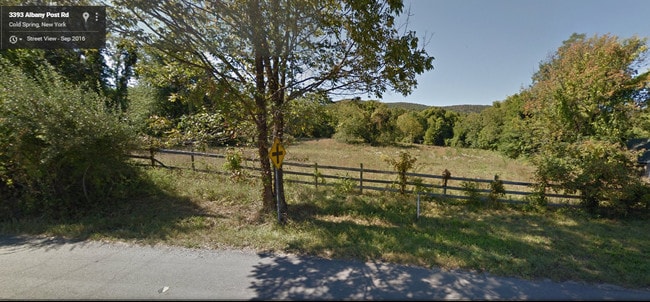
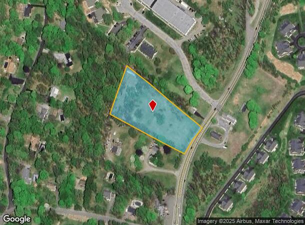
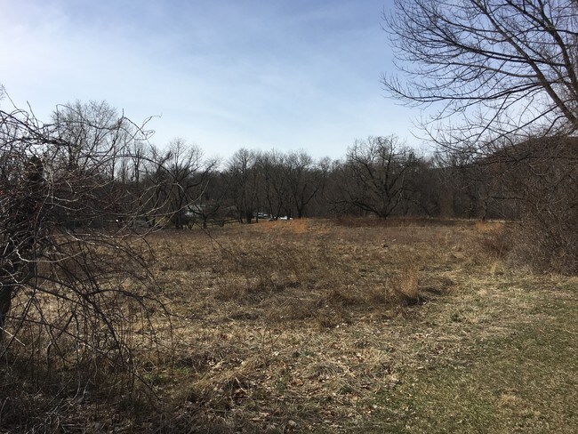
Property Record
3393 Route 9, Cold Spring, NY 10516
NEARBY LISTINGS FOR SALE OR LEASE
-
-
View all Cold Spring listings for sale on LoopNet.com
Property Detail
3393 Route 9
Dutchess County-Putnam County, NY
LAND
372689-016-016-0001-019-000-0000
Putnam
Commercialacreage
New York
X
19.00
36079C0081E
3.19 AC
2024
Carmel
2024
Westchester/So Connecticut
010600
DEMOGRAPHICS near 3393 Route 9
1 Mile
3 Mile
5 Mile
2024 Total Population
1,136
7,759
38,772
2029 Population
1,148
7,759
38,881
Pop Growth 2024-2029
+ 1.06%
0.00%
+ 0.28%
Average Age
47
44
44
2024 Total Households
458
3,150
16,065
HH Growth 2024-2029
+ 1.09%
(0.06%)
+ 0.23%
Median Household Inc
$132,267
$113,855
$91,609
Avg Household Size
2.40
2.40
2.20
2024 Avg HH Vehicles
2.00
2.00
2.00
Median Home Value
$664,251
$444,531
$417,155
Median Year Built
1978
1966
1973
Nearby Places
- Restaurants
- Banks
- Shops
- Fitness
- Groceries
PUBLIC TRANSPORTATION
COMMUTER RAIL
Breakneck Ridge Station (Hudson Line - Metro-North Commuter Railroad Company (Metro-North))
DRIVE
WALK
Distance
Breakneck Ridge Station (Hudson Line - Metro-North Commuter Railroad Company (Metro-North))
12 min
7.9 mi
AIRPORT
New York Stewart International
DRIVE
WALK
Distance
New York Stewart International
29 min
18.7 mi
Freight Ports
Port of New Haven
DRIVE
WALK
Distance
Port of New Haven
96 min
70.9 mi
SALE & LEASE HISTORY
LISTING DATE
SALE/LEASE

Nov 13, 2018
For Sale
Apr 03, 2017
For Sale
Nearby Properties
Address
Land Use
TOTAL SIZE
Lot Size
Zoning
Address
Land Use
TOTAL SIZE
Lot Size
Zoning
36.65 AC
R1-20
Address
Land Use
TOTAL SIZE
Lot Size
Zoning
9.17 AC
RD-3
Address
Land Use
TOTAL SIZE
Lot Size
Zoning
12 AC
R1-10
Address
Land Use
TOTAL SIZE
Lot Size
Zoning
32,347 SF
17.10 AC
R20
Address
Land Use
TOTAL SIZE
Lot Size
Zoning
2.69 AC
HI
Address
Land Use
TOTAL SIZE
Lot Size
Zoning
1.30 AC
RD-3
Address
Land Use
TOTAL SIZE
Lot Size
Zoning
494.40 AC
R4A
Address
Land Use
TOTAL SIZE
Lot Size
Zoning
300 AC
R4A
Address
Land Use
TOTAL SIZE
Lot Size
Zoning
73,224 SF
464.99 AC
R80
Address
Land Use
TOTAL SIZE
Lot Size
Zoning
288.30 AC
R4A
Address
Land Use
TOTAL SIZE
Lot Size
Zoning
25.30 AC
R4A
Address
Land Use
TOTAL SIZE
Lot Size
Zoning
308.79 AC
GB/R4
Address
Land Use
TOTAL SIZE
Lot Size
Zoning
271.30 AC
R4A
Address
Land Use
TOTAL SIZE
Lot Size
Zoning
2.07 AC
R120
Address
Land Use
TOTAL SIZE
Lot Size
Zoning
40,796 SF
125.03 AC
R80
Address
Land Use
TOTAL SIZE
Lot Size
Zoning
583.48 AC
R4A
Address
Land Use
TOTAL SIZE
Lot Size
Zoning
51.25 AC
R1-20
Address
Land Use
TOTAL SIZE
Lot Size
Zoning
8.30 AC
RD-3
Address
Land Use
TOTAL SIZE
Lot Size
Zoning
7.03 AC
R1-20
Address
Land Use
TOTAL SIZE
Lot Size
Zoning
57.30 AC
R1-20
Address
Land Use
TOTAL SIZE
Lot Size
Zoning
10,395 SF
0.12 AC
GB
Address
Land Use
TOTAL SIZE
Lot Size
Zoning
520.21 AC
R80
Address
Land Use
TOTAL SIZE
Lot Size
Zoning
Address
Land Use
TOTAL SIZE
Lot Size
Zoning
477.17 AC
R4A
Address
Land Use
TOTAL SIZE
Lot Size
Zoning
324 AC
R80
Address
Land Use
TOTAL SIZE
Lot Size
Zoning
164.34 AC
R4A
Address
Land Use
TOTAL SIZE
Lot Size
Zoning
108.40 AC
Address
Land Use
TOTAL SIZE
Lot Size
Zoning
6,892 SF
4.35 AC
R1-5
Address
Land Use
TOTAL SIZE
Lot Size
Zoning
88.50 AC
R1-40
Address
Land Use
TOTAL SIZE
Lot Size
Zoning
The World's #1 Commercial Real Estate Marketplace
Connect with us
© 2025 CoStar Group
The information above has been obtained from sources believed reliable. While we do not doubt its accuracy we have not verified it and make no guarantee, warranty or representation about it. It is your responsibility to independently confirm its accuracy and completeness. Any projections, opinions, assumptions, or estimates used are for example only and do not represent the current or future performance of the property. The value of this transaction to you depends on tax and other factors which should be evaluated by your tax, financial, and legal advisors. You and your advisors should conduct a careful, independent investigation of the property to determine to your satisfaction the suitability of the property for your needs.