Property Record
3395 Sw 74Th Ave, Ocala, FL 34474

NEARBY LISTINGS FOR SALE OR LEASE
Property Detail
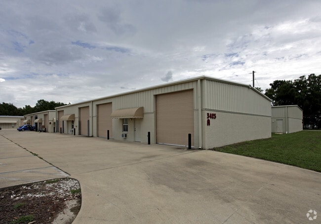
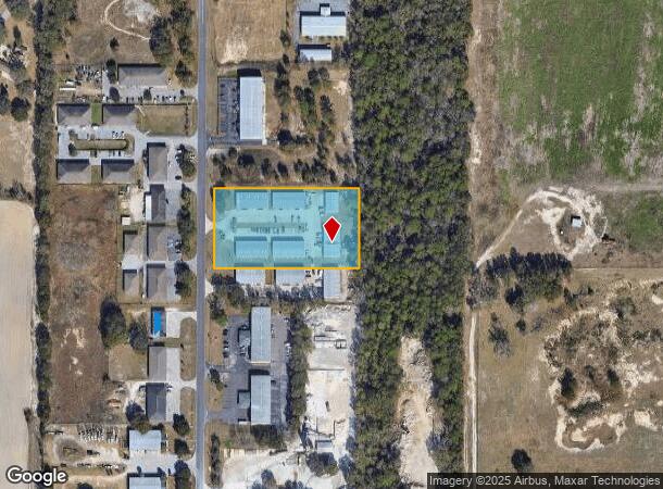
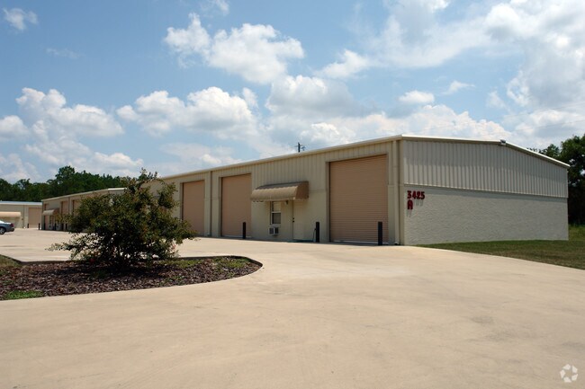
3395 Sw 74Th Ave
Ocala, FL
Airport Industrial Park
23824-002-11
SEC 30 TWP 15 RGE 21 PLAT BOOK 1 PAGE 092 AIRPORT INDUSTRIAL PARK BLK B LOT 11.12
Warehouse
Marion
X
Florida
12083C0513E
11
2025
2.62 AC
2025
Greater Ocala
002506
Ocala
26,100 SF
DEMOGRAPHICS near 3395 Sw 74Th Ave
1 Mile
3 Mile
5 Mile
2024 Total Population
220
13,253
50,111
2029 Population
250
14,929
56,747
Pop Growth 2024-2029
+ 13.64%
+ 12.65%
+ 13.24%
Average Age
47
45
50
2024 Total Households
90
5,645
21,867
HH Growth 2024-2029
+ 13.33%
+ 12.61%
+ 13.36%
Median Household Inc
$67,500
$58,853
$56,760
Avg Household Size
2.40
2.30
2.10
2024 Avg HH Vehicles
2.00
2.00
1.00
Median Home Value
$269,230
$216,848
$229,132
Median Year Built
1999
1996
1997
Nearby Places
Map Layers
Map Styles
 Street
 Aerial
- Restaurants
- Banks
- Shops
- Fitness
- Groceries
Nearby Properties
Address
Land Use
TOTAL SIZE
Lot Size
Zoning
Address
Land Use
TOTAL SIZE
Lot Size
Zoning
2,015,469 SF
169.30 AC
M1
Address
Land Use
TOTAL SIZE
Lot Size
Zoning
493,261 SF
126.01 AC
R3
Address
Land Use
TOTAL SIZE
Lot Size
Zoning
156,201 SF
36.77 AC
INST
Address
Land Use
TOTAL SIZE
Lot Size
Zoning
192,480 SF
23.19 AC
R3
Address
Land Use
TOTAL SIZE
Lot Size
Zoning
324,262 SF
40.79 AC
SC
Address
Land Use
TOTAL SIZE
Lot Size
Zoning
189,662 SF
25.54 AC
B2
Address
Land Use
TOTAL SIZE
Lot Size
Zoning
380,749 SF
40.05 AC
PUD
Address
Land Use
TOTAL SIZE
Lot Size
Zoning
322,193 SF
70.13 AC
INST
Address
Land Use
TOTAL SIZE
Lot Size
Zoning
152,355 SF
973.50 AC
GU
Address
Land Use
TOTAL SIZE
Lot Size
Zoning
59,706 SF
10.01 AC
PD
Address
Land Use
TOTAL SIZE
Lot Size
Zoning
392,617 SF
23.83 AC
M1
Address
Land Use
TOTAL SIZE
Lot Size
Zoning
113,501 SF
68.56 AC
INST
Address
Land Use
TOTAL SIZE
Lot Size
Zoning
364,404 SF
31.83 AC
M1
Address
Land Use
TOTAL SIZE
Lot Size
Zoning
92,095 SF
216.43 AC
M1
Address
Land Use
TOTAL SIZE
Lot Size
Zoning
95,496 SF
25.25 AC
R3
Address
Land Use
TOTAL SIZE
Lot Size
Zoning
68,372 SF
21.78 AC
B4
Address
Land Use
TOTAL SIZE
Lot Size
Zoning
44,276 SF
5 AC
O1
Address
Land Use
TOTAL SIZE
Lot Size
Zoning
84,004 SF
9.77 AC
SC
Address
Land Use
TOTAL SIZE
Lot Size
Zoning
23,783 SF
3.27 AC
B2
Address
Land Use
TOTAL SIZE
Lot Size
Zoning
56,605 SF
4.12 AC
B2
Address
Land Use
TOTAL SIZE
Lot Size
Zoning
60,706 SF
84.49 AC
PUD
Address
Land Use
TOTAL SIZE
Lot Size
Zoning
81,299 SF
18.32 AC
A1
Address
Land Use
TOTAL SIZE
Lot Size
Zoning
101,760 SF
9.88 AC
M1
Address
Land Use
TOTAL SIZE
Lot Size
Zoning
14,122 SF
73.47 AC
A1
Address
Land Use
TOTAL SIZE
Lot Size
Zoning
120,571 SF
10.34 AC
M1
Address
Land Use
TOTAL SIZE
Lot Size
Zoning
11,837 SF
3.99 AC
OP
Address
Land Use
TOTAL SIZE
Lot Size
Zoning
145,089 SF
7.66 AC
M1
Address
Land Use
TOTAL SIZE
Lot Size
Zoning
136,550 SF
11.02 AC
M1
Address
Land Use
TOTAL SIZE
Lot Size
Zoning
100,367 SF
6.40 AC
M1
Address
Land Use
TOTAL SIZE
Lot Size
Zoning
20,982 SF
4 AC
O1
The World's #1 Commercial Real Estate Marketplace
Connect with us
© 2026 CoStar Group
The information above has been obtained from sources believed reliable. While we do not doubt its accuracy we have not verified it and make no guarantee, warranty or representation about it. It is your responsibility to independently confirm its accuracy and completeness. Any projections, opinions, assumptions, or estimates used are for example only and do not represent the current or future performance of the property. The value of this transaction to you depends on tax and other factors which should be evaluated by your tax, financial, and legal advisors. You and your advisors should conduct a careful, independent investigation of the property to determine to your satisfaction the suitability of the property for your needs.