Property Record
60 Acres St, Burlington, IA 52601
NEARBY LISTINGS FOR SALE OR LEASE
-
-
View all Burlington listings for sale on LoopNet.com
Property Detail
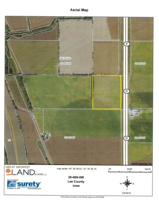
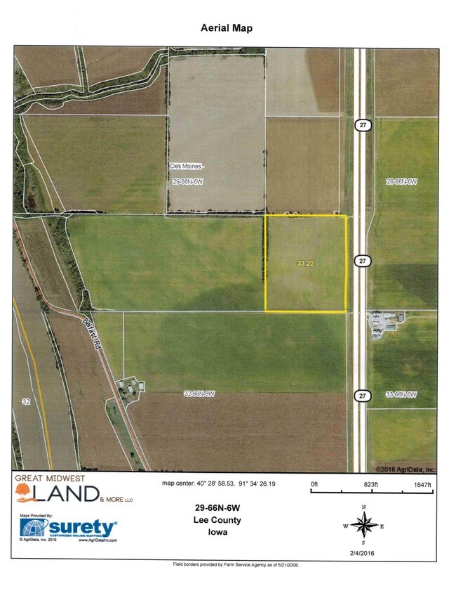
60 Acres St
Burlington, IA-IL
Prospect Heights Sub
16-09-130-015
Des Moines
Sfr
Iowa
X
0.13 AC
19057C0286F
Iowa Southeast Area
1,176 SF
Other Market Areas
DEMOGRAPHICS near 60 Acres St
1 Mile
3 Mile
5 Mile
2024 Total Population
5,348
20,926
28,699
2029 Population
5,217
20,392
28,043
Pop Growth 2024-2029
(2.45%)
(2.55%)
(2.29%)
Average Age
41
41
42
2024 Total Households
2,341
9,296
12,694
HH Growth 2024-2029
(2.48%)
(2.61%)
(2.34%)
Median Household Inc
$50,066
$47,889
$51,116
Avg Household Size
2.20
2.20
2.20
2024 Avg HH Vehicles
2.00
2.00
2.00
Median Home Value
$87,837
$97,679
$116,719
Median Year Built
1946
1948
1952
Nearby Places
Map Layers
Map Styles
 Street
 Aerial
- Restaurants
- Banks
- Shops
- Fitness
- Groceries
PUBLIC TRANSPORTATION
COMMUTER RAIL
Burlington Amtrak Station (California Zephyr - Amtrak)
DRIVE
WALK
Distance
Burlington Amtrak Station (California Zephyr - Amtrak)
3 min
20 min
1.0 mi
Freight Ports
Port Milwaukee
DRIVE
WALK
Distance
Port Milwaukee
323 min
283.4 mi
SALE & LEASE HISTORY
LISTING DATE
SALE/LEASE

Sep 05, 2017
For Sale
Jun 15, 2018
For Sale
Nearby Properties
Address
Land Use
TOTAL SIZE
Lot Size
Zoning
Address
Land Use
TOTAL SIZE
Lot Size
Zoning
411,660 SF
35.16 AC
Address
Land Use
TOTAL SIZE
Lot Size
Zoning
12,768 SF
489.69 AC
R1
Address
Land Use
TOTAL SIZE
Lot Size
Zoning
25,884 SF
13.02 AC
Address
Land Use
TOTAL SIZE
Lot Size
Zoning
25,818 SF
2.66 AC
C3
Address
Land Use
TOTAL SIZE
Lot Size
Zoning
77,637 SF
13.99 AC
Address
Land Use
TOTAL SIZE
Lot Size
Zoning
873,791 SF
139.78 AC
M2
Address
Land Use
TOTAL SIZE
Lot Size
Zoning
28,120 SF
2.90 AC
Address
Land Use
TOTAL SIZE
Lot Size
Zoning
95,304 SF
10.29 AC
Address
Land Use
TOTAL SIZE
Lot Size
Zoning
61,245 SF
2.72 AC
Address
Land Use
TOTAL SIZE
Lot Size
Zoning
42,306 SF
0.33 AC
Address
Land Use
TOTAL SIZE
Lot Size
Zoning
134,068 SF
40.60 AC
R2
Address
Land Use
TOTAL SIZE
Lot Size
Zoning
58,769 SF
7.56 AC
C2
Address
Land Use
TOTAL SIZE
Lot Size
Zoning
45,054 SF
14.15 AC
M2
Address
Land Use
TOTAL SIZE
Lot Size
Zoning
60,646 SF
8.58 AC
Address
Land Use
TOTAL SIZE
Lot Size
Zoning
18,350 SF
5 AC
Address
Land Use
TOTAL SIZE
Lot Size
Zoning
51,188 SF
12.90 AC
Address
Land Use
TOTAL SIZE
Lot Size
Zoning
18,151 SF
8.01 AC
Address
Land Use
TOTAL SIZE
Lot Size
Zoning
16,688 SF
5.12 AC
C3
Address
Land Use
TOTAL SIZE
Lot Size
Zoning
43,416 SF
23.42 AC
Address
Land Use
TOTAL SIZE
Lot Size
Zoning
3,998 SF
11.52 AC
Address
Land Use
TOTAL SIZE
Lot Size
Zoning
140,784 SF
22.87 AC
M2
Address
Land Use
TOTAL SIZE
Lot Size
Zoning
100,460 SF
0.66 AC
Address
Land Use
TOTAL SIZE
Lot Size
Zoning
84,736 SF
7.23 AC
C2
Address
Land Use
TOTAL SIZE
Lot Size
Zoning
9,792 SF
7.66 AC
Address
Land Use
TOTAL SIZE
Lot Size
Zoning
107,485 SF
24.25 AC
M2
Address
Land Use
TOTAL SIZE
Lot Size
Zoning
22,646 SF
0.38 AC
Address
Land Use
TOTAL SIZE
Lot Size
Zoning
36,470 SF
2.24 AC
Address
Land Use
TOTAL SIZE
Lot Size
Zoning
5,536 SF
7.67 AC
R4
Address
Land Use
TOTAL SIZE
Lot Size
Zoning
84,580 SF
6.87 AC
Address
Land Use
TOTAL SIZE
Lot Size
Zoning
64,468 SF
28.82 AC
R2
The World's #1 Commercial Real Estate Marketplace
Connect with us
© 2025 CoStar Group
The information above has been obtained from sources believed reliable. While we do not doubt its accuracy we have not verified it and make no guarantee, warranty or representation about it. It is your responsibility to independently confirm its accuracy and completeness. Any projections, opinions, assumptions, or estimates used are for example only and do not represent the current or future performance of the property. The value of this transaction to you depends on tax and other factors which should be evaluated by your tax, financial, and legal advisors. You and your advisors should conduct a careful, independent investigation of the property to determine to your satisfaction the suitability of the property for your needs.