Property Record
34 Avery Rd, Cranston, RI 02910
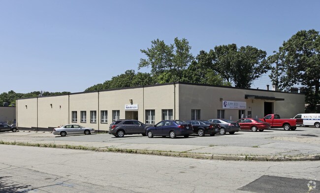

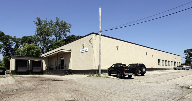
Property Detail
34 Avery Rd
CRAN-000005-000003-001036
Providence
Industrialgeneral
Rhode Island
M2
1036
AE The base floodplain where base flood elevations are provided. AE Zones are now used on new format FIRMs instead of A1-A30 Zones.
0.82 AC
2025
Cranston
2025
Providence
013600
Providence-Warwick, RI-MA
16,482 SF
NEARBY LISTINGS FOR SALE OR LEASE
DEMOGRAPHICS near 34 Avery Rd
1 mile
3 mile
5 mile
2025 Total Population
13,471
117,279
321,997
2030 Population
13,741
119,746
329,720
Pop Growth 2025-2030
+ 2.00%
+ 2.10%
+ 2.40%
Average Age
41
41
40
2025 Total Households
5,545
45,809
127,101
HH Growth 2025-2030
+ 2.02%
+ 2.15%
+ 2.59%
Median Household Inc
$85,262
$74,811
$76,186
Avg Household Size
2.40
2.40
2.40
2025 Avg HH Vehicles
2.00
2.00
2.00
Median Home Value
$317,098
$359,444
$361,874
Median Year Built
1952
1951
1954
Nearby Places
Map Layers
Map Styles
 Street
 Aerial
Layers
 Traffic
 Biking
Places
Listings with unknown addresses are not visible on the map
- Restaurants
- Banks
- Shops
- Fitness
- Groceries
PUBLIC TRANSPORTATION
COMMUTER RAIL
Drive
Walk
Distance
10 min
3.5 mi
Providence (Providence/Stoughton Line - Massachusetts Bay Transportation Authority Commuter Rail (Purple Line))
Drive
Walk
Distance
Providence (Providence/Stoughton Line - Massachusetts Bay Transportation Authority Commuter Rail (Purple Line))
13 min
6.9 mi
AIRPORT
Rhode Island Tf Green International
Drive
Walk
Distance
Rhode Island Tf Green International
13 min
4.4 mi
Worcester Regional
Drive
Walk
Distance
Worcester Regional
70 min
49.6 mi
Freight Ports
Port of Davisville, RI
Drive
Walk
Distance
Port of Davisville, RI
32 min
17.6 mi
SALE & LEASE HISTORY
LISTING DATE
SALE/LEASE

Nov 04, 2016
For Lease
Nearby Properties
Address
Land Use
TOTAL SIZE
Lot Size
Zoning
Address
Land Use
TOTAL SIZE
Lot Size
Zoning
39.98 AC
S1
Address
Land Use
TOTAL SIZE
Lot Size
Zoning
45,000 SF
22.22 AC
M2
Address
Land Use
TOTAL SIZE
Lot Size
Zoning
13.40 AC
C3
Address
Land Use
TOTAL SIZE
Lot Size
Zoning
36.43 AC
S1
Address
Land Use
TOTAL SIZE
Lot Size
Zoning
33.13 AC
S1
Address
Land Use
TOTAL SIZE
Lot Size
Zoning
9.38 AC
S1
Address
Land Use
TOTAL SIZE
Lot Size
Zoning
7.53 AC
I-2
Address
Land Use
TOTAL SIZE
Lot Size
Zoning
4,954 SF
11.22 AC
C5
Address
Land Use
TOTAL SIZE
Lot Size
Zoning
4,212 SF
32.62 AC
S1
Address
Land Use
TOTAL SIZE
Lot Size
Zoning
485,238 SF
2.05 AC
GB
Address
Land Use
TOTAL SIZE
Lot Size
Zoning
6,702 SF
49.97 AC
GI
Address
Land Use
TOTAL SIZE
Lot Size
Zoning
27.47 AC
S1
Address
Land Use
TOTAL SIZE
Lot Size
Zoning
99,500 SF
4.94 AC
PS
Address
Land Use
TOTAL SIZE
Lot Size
Zoning
27.46 AC
C4
Address
Land Use
TOTAL SIZE
Lot Size
Zoning
517,743 SF
3.55 AC
GI
Address
Land Use
TOTAL SIZE
Lot Size
Zoning
104,999 SF
8.86 AC
C-3
Address
Land Use
TOTAL SIZE
Lot Size
Zoning
102,425 SF
11.66 AC
S1
Address
Land Use
TOTAL SIZE
Lot Size
Zoning
491,496 SF
46.72 AC
LI
Address
Land Use
TOTAL SIZE
Lot Size
Zoning
247,671 SF
10.78 AC
A7
Address
Land Use
TOTAL SIZE
Lot Size
Zoning
10.90 AC
EI
Address
Land Use
TOTAL SIZE
Lot Size
Zoning
10.78 AC
MPD
Address
Land Use
TOTAL SIZE
Lot Size
Zoning
57,068 SF
3.73 AC
Address
Land Use
TOTAL SIZE
Lot Size
Zoning
4.91 AC
I-2
Address
Land Use
TOTAL SIZE
Lot Size
Zoning
Address
Land Use
TOTAL SIZE
Lot Size
Zoning
2,308 SF
12.82 AC
B2
Address
Land Use
TOTAL SIZE
Lot Size
Zoning
12.81 AC
A8
Address
Land Use
TOTAL SIZE
Lot Size
Zoning
138,056 SF
3.22 AC
PS
Address
Land Use
TOTAL SIZE
Lot Size
Zoning
77,631 SF
2.97 AC
I-2
Address
Land Use
TOTAL SIZE
Lot Size
Zoning
81,129 SF
5.75 AC
A8
Address
Land Use
TOTAL SIZE
Lot Size
Zoning
6.30 AC
PS
The World's #1 Commercial Real Estate Marketplace
Connect with us
© 2026 CoStar Group
The information above has been obtained from sources believed reliable. While we do not doubt its accuracy we have not verified it and make no guarantee, warranty or representation about it. It is your responsibility to independently confirm its accuracy and completeness. Any projections, opinions, assumptions, or estimates used are for example only and do not represent the current or future performance of the property. The value of this transaction to you depends on tax and other factors which should be evaluated by your tax, financial, and legal advisors. You and your advisors should conduct a careful, independent investigation of the property to determine to your satisfaction the suitability of the property for your needs.