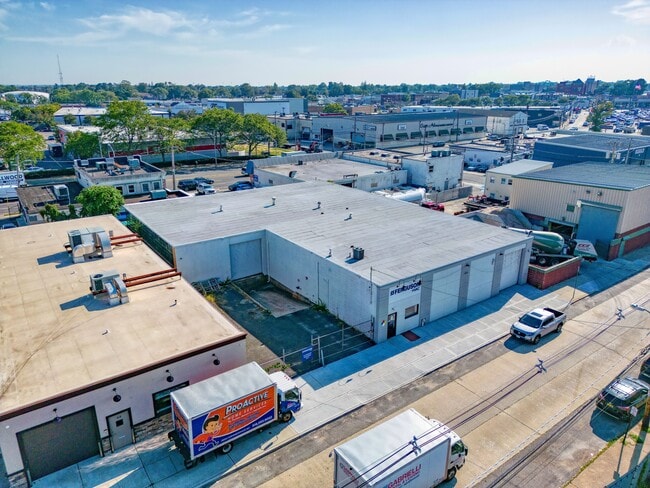
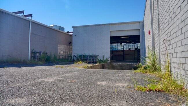
Property Record
34 Bennington Ave, Freeport, NY 11520

Current Lease Availabilities
Property Detail
34 Bennington Ave
Nassau County-Suffolk County, NY
91-94
2009-55-201-00-0091-0
Nassau
Warehouse
New York
B and X Area of moderate flood hazard, usually the area between the limits of the 100-year and 500-year floods.
91-94
2025
0.29 AC
2025
Southern Nassau
414400
Long Island (New York)
9,100 SF
NEARBY LISTINGS FOR SALE OR LEASE
DEMOGRAPHICS near 34 Bennington Ave
1 mile
3 mile
5 mile
2025 Total Population
28,424
183,816
436,347
2030 Population
28,395
183,498
435,791
Pop Growth 2025-2030
(0.10%)
(0.17%)
(0.13%)
Average Age
39
41
41
2025 Total Households
8,360
56,484
136,700
HH Growth 2025-2030
(0.11%)
(0.21%)
(0.17%)
Median Household Inc
$103,213
$140,572
$133,876
Avg Household Size
3.20
3.10
3.00
2025 Avg HH Vehicles
2.00
2.00
2.00
Median Home Value
$498,593
$673,290
$683,875
Median Year Built
1950
1952
1953
Nearby Places
Map Layers
Map Styles
 Street
 Aerial
Layers
 Traffic
 Biking
Places
Listings with unknown addresses are not visible on the map
- Restaurants
- Banks
- Shops
- Fitness
- Groceries
PUBLIC TRANSPORTATION
TRANSIT/SUBWAY
Freeport Station (Babylon Branch - Long Island Rail Road)
Drive
Walk
Distance
Freeport Station (Babylon Branch - Long Island Rail Road)
1 min
6 min
0.3 mi
COMMUTER RAIL
Freeport Station (Babylon Branch - Long Island Rail Road)
Drive
Walk
Distance
Freeport Station (Babylon Branch - Long Island Rail Road)
1 min
6 min
0.3 mi
Merrick Station (Babylon Branch - Long Island Rail Road)
Drive
Walk
Distance
Merrick Station (Babylon Branch - Long Island Rail Road)
3 min
1.7 mi
AIRPORT
John F Kennedy International
Drive
Walk
Distance
John F Kennedy International
21 min
13.7 mi
LaGuardia
Drive
Walk
Distance
LaGuardia
32 min
20.6 mi
Long Island MacArthur
Drive
Walk
Distance
Long Island MacArthur
40 min
29.5 mi
Freight Ports
NY - Red Hook Container Terminal
Drive
Walk
Distance
NY - Red Hook Container Terminal
42 min
25.1 mi
Nearby Properties
Address
Land Use
TOTAL SIZE
Lot Size
Zoning
Address
Land Use
TOTAL SIZE
Lot Size
Zoning
5,800 SF
10.48 AC
Address
Land Use
TOTAL SIZE
Lot Size
Zoning
986.74 AC
Address
Land Use
TOTAL SIZE
Lot Size
Zoning
169.25 AC
Address
Land Use
TOTAL SIZE
Lot Size
Zoning
336,450 SF
139.91 AC
Address
Land Use
TOTAL SIZE
Lot Size
Zoning
341,098 SF
31.88 AC
Address
Land Use
TOTAL SIZE
Lot Size
Zoning
19.88 AC
Address
Land Use
TOTAL SIZE
Lot Size
Zoning
57,970 SF
1.69 AC
Address
Land Use
TOTAL SIZE
Lot Size
Zoning
57,874 SF
21 AC
Address
Land Use
TOTAL SIZE
Lot Size
Zoning
65,235 SF
15.48 AC
Address
Land Use
TOTAL SIZE
Lot Size
Zoning
94,204 SF
35.42 AC
Address
Land Use
TOTAL SIZE
Lot Size
Zoning
116.80 AC
Address
Land Use
TOTAL SIZE
Lot Size
Zoning
145,209 SF
20.01 AC
Address
Land Use
TOTAL SIZE
Lot Size
Zoning
140,000 SF
50.78 AC
Address
Land Use
TOTAL SIZE
Lot Size
Zoning
67,408 SF
66.13 AC
Address
Land Use
TOTAL SIZE
Lot Size
Zoning
80,895 SF
26.22 AC
Address
Land Use
TOTAL SIZE
Lot Size
Zoning
225,460 SF
14.70 AC
Address
Land Use
TOTAL SIZE
Lot Size
Zoning
86.38 AC
Address
Land Use
TOTAL SIZE
Lot Size
Zoning
357,868 SF
24.92 AC
Address
Land Use
TOTAL SIZE
Lot Size
Zoning
377,041 SF
14.43 AC
Address
Land Use
TOTAL SIZE
Lot Size
Zoning
140,992 SF
12.07 AC
Address
Land Use
TOTAL SIZE
Lot Size
Zoning
253,201 SF
16.01 AC
Address
Land Use
TOTAL SIZE
Lot Size
Zoning
168,070 SF
11.29 AC
Address
Land Use
TOTAL SIZE
Lot Size
Zoning
266,638 SF
16.95 AC
Address
Land Use
TOTAL SIZE
Lot Size
Zoning
82,698 SF
12.03 AC
Address
Land Use
TOTAL SIZE
Lot Size
Zoning
65,102 SF
27.67 AC
Address
Land Use
TOTAL SIZE
Lot Size
Zoning
278,714 SF
3.04 AC
Address
Land Use
TOTAL SIZE
Lot Size
Zoning
193,285 SF
9.64 AC
Address
Land Use
TOTAL SIZE
Lot Size
Zoning
70,104 SF
12.19 AC
Address
Land Use
TOTAL SIZE
Lot Size
Zoning
142,728 SF
14.52 AC
Address
Land Use
TOTAL SIZE
Lot Size
Zoning
16,122 SF
160.92 AC
The World's #1 Commercial Real Estate Marketplace
Connect with us
© 2026 CoStar Group
The information above has been obtained from sources believed reliable. While we do not doubt its accuracy we have not verified it and make no guarantee, warranty or representation about it. It is your responsibility to independently confirm its accuracy and completeness. Any projections, opinions, assumptions, or estimates used are for example only and do not represent the current or future performance of the property. The value of this transaction to you depends on tax and other factors which should be evaluated by your tax, financial, and legal advisors. You and your advisors should conduct a careful, independent investigation of the property to determine to your satisfaction the suitability of the property for your needs.