Property Record
34 Chenango Ave, Clinton, NY 13323


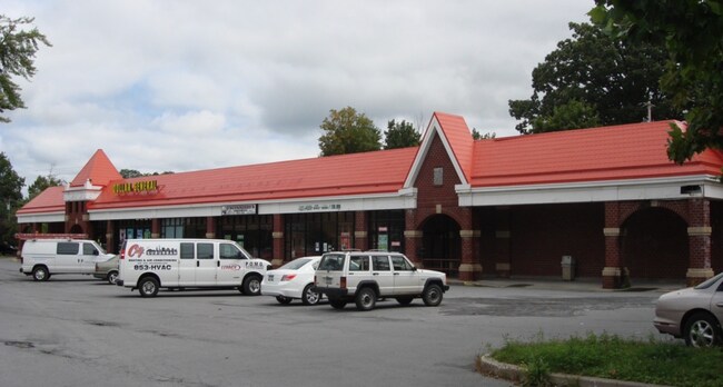
Property Detail
34 Chenango Ave
337-018-0002-031-000-0000
Oneida
Supermarket
New York
B and X Area of moderate flood hazard, usually the area between the limits of the 100-year and 500-year floods.
31.000
2025
2.90 AC
2025
Outlying Oneida County
025002
Utica/Rome
25,245 SF
Utica-Rome, NY
NEARBY LISTINGS FOR SALE OR LEASE
DEMOGRAPHICS near 34 Chenango Ave
1 mile
3 mile
5 mile
2025 Total Population
3,404
12,064
26,664
2030 Population
3,392
12,011
26,519
Pop Growth 2025-2030
(0.35%)
(0.44%)
(0.54%)
Average Age
45
43
44
2025 Total Households
1,614
4,762
11,088
HH Growth 2025-2030
(0.43%)
(0.44%)
(0.59%)
Median Household Inc
$91,145
$71,116
$81,615
Avg Household Size
2.10
2.10
2.20
2025 Avg HH Vehicles
2.00
2.00
2.00
Median Home Value
$285,031
$246,339
$239,237
Median Year Built
1949
1964
1963
Nearby Places
Map Layers
Map Styles
 Street
 Aerial
Layers
 Traffic
 Biking
Places
Listings with unknown addresses are not visible on the map
- Restaurants
- Banks
- Shops
- Fitness
- Groceries
PUBLIC TRANSPORTATION
COMMUTER RAIL
Drive
Walk
Distance
17 min
9.5 mi
SALE & LEASE HISTORY
LISTING DATE
SALE/LEASE

Sep 25, 2016
For Lease
Jan 08, 2020
For Sale
Nearby Properties
Address
Land Use
TOTAL SIZE
Lot Size
Zoning
Address
Land Use
TOTAL SIZE
Lot Size
Zoning
122.70 AC
01 - NOT Z
Address
Land Use
TOTAL SIZE
Lot Size
Zoning
49,900 SF
74.61 AC
Address
Land Use
TOTAL SIZE
Lot Size
Zoning
3,276 SF
6.38 AC
05 - COMME
Address
Land Use
TOTAL SIZE
Lot Size
Zoning
208,282 SF
24.30 AC
Address
Land Use
TOTAL SIZE
Lot Size
Zoning
1,764 SF
75.36 AC
05 - COMME
Address
Land Use
TOTAL SIZE
Lot Size
Zoning
124,169 SF
9.96 AC
05 - COMME
Address
Land Use
TOTAL SIZE
Lot Size
Zoning
131,760 SF
120.07 AC
05 - COMME
Address
Land Use
TOTAL SIZE
Lot Size
Zoning
4,136 SF
92.70 AC
01 - NOT Z
Address
Land Use
TOTAL SIZE
Lot Size
Zoning
3,276 SF
5.33 AC
05 - COMME
Address
Land Use
TOTAL SIZE
Lot Size
Zoning
75,000 SF
8.75 AC
Address
Land Use
TOTAL SIZE
Lot Size
Zoning
149,008 SF
14.10 AC
Address
Land Use
TOTAL SIZE
Lot Size
Zoning
76,000 SF
14 AC
Address
Land Use
TOTAL SIZE
Lot Size
Zoning
55,202 SF
14 AC
01
Address
Land Use
TOTAL SIZE
Lot Size
Zoning
924 SF
20.80 AC
Address
Land Use
TOTAL SIZE
Lot Size
Zoning
52,010 SF
3.10 AC
01 - NOT Z
Address
Land Use
TOTAL SIZE
Lot Size
Zoning
63.60 AC
Address
Land Use
TOTAL SIZE
Lot Size
Zoning
65.18 AC
01 - NOT Z
Address
Land Use
TOTAL SIZE
Lot Size
Zoning
76,032 SF
4.50 AC
Address
Land Use
TOTAL SIZE
Lot Size
Zoning
37.26 AC
01
Address
Land Use
TOTAL SIZE
Lot Size
Zoning
20,660 SF
7.54 AC
Address
Land Use
TOTAL SIZE
Lot Size
Zoning
Address
Land Use
TOTAL SIZE
Lot Size
Zoning
Address
Land Use
TOTAL SIZE
Lot Size
Zoning
924 SF
15.80 AC
05 - COMME
Address
Land Use
TOTAL SIZE
Lot Size
Zoning
35,000 SF
3 AC
Address
Land Use
TOTAL SIZE
Lot Size
Zoning
19,928 SF
4.10 AC
01
Address
Land Use
TOTAL SIZE
Lot Size
Zoning
Address
Land Use
TOTAL SIZE
Lot Size
Zoning
8,784 SF
8.70 AC
05 - COMME
Address
Land Use
TOTAL SIZE
Lot Size
Zoning
22,136 SF
3 AC
05 - COMME
Address
Land Use
TOTAL SIZE
Lot Size
Zoning
672 SF
5.20 AC
Address
Land Use
TOTAL SIZE
Lot Size
Zoning
20,160 SF
4.50 AC
05 - COMME
The World's #1 Commercial Real Estate Marketplace
Connect with us
© 2026 CoStar Group
The information above has been obtained from sources believed reliable. While we do not doubt its accuracy we have not verified it and make no guarantee, warranty or representation about it. It is your responsibility to independently confirm its accuracy and completeness. Any projections, opinions, assumptions, or estimates used are for example only and do not represent the current or future performance of the property. The value of this transaction to you depends on tax and other factors which should be evaluated by your tax, financial, and legal advisors. You and your advisors should conduct a careful, independent investigation of the property to determine to your satisfaction the suitability of the property for your needs.