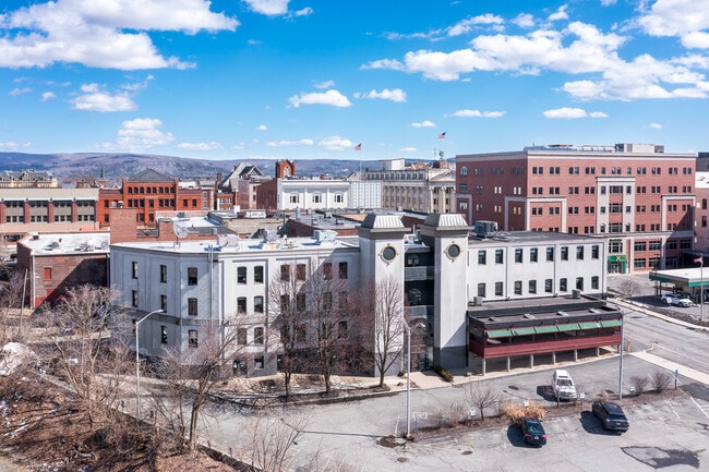
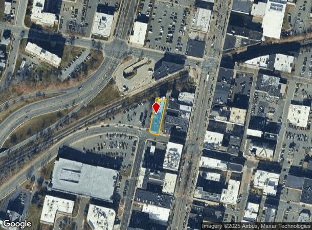
Property Record
34 Depot St, Pittsfield, MA 01201
Current Lease Availabilities
NEARBY LISTINGS FOR SALE OR LEASE
Property Detail
34 Depot St
Pittsfield, MA
Berkshire
PITT-000009H-000023-000003
Massachusetts
Commercialnec
3
2025
0.24 AC
2025
Massachusetts North/West Area
900100
Other Market Areas
DEMOGRAPHICS near 34 Depot St
1 Mile
3 Mile
5 Mile
2024 Total Population
15,098
38,820
50,499
2029 Population
14,793
38,138
49,796
Pop Growth 2024-2029
(2.02%)
(1.76%)
(1.39%)
Average Age
41
44
45
2024 Total Households
7,039
17,410
22,535
HH Growth 2024-2029
(2.05%)
(1.85%)
(1.46%)
Median Household Inc
$34,028
$56,986
$59,857
Avg Household Size
2.00
2.10
2.10
2024 Avg HH Vehicles
1.00
1.00
2.00
Median Home Value
$175,231
$209,156
$227,071
Median Year Built
1946
1948
1951
Nearby Places
Map Layers
Map Styles
 Street
 Aerial
- Restaurants
- Banks
- Shops
- Fitness
- Groceries
PUBLIC TRANSPORTATION
COMMUTER RAIL
DRIVE
WALK
Distance
1 min
3 min
0.2 mi
AIRPORT
Albany International
DRIVE
WALK
Distance
Albany International
73 min
45.6 mi
Freight Ports
Albany, NY Port
DRIVE
WALK
Distance
Albany, NY Port
63 min
40.2 mi
Nearby Properties
Address
Land Use
TOTAL SIZE
Lot Size
Zoning
Address
Land Use
TOTAL SIZE
Lot Size
Zoning
8.36 AC
BG
Address
Land Use
TOTAL SIZE
Lot Size
Zoning
363,252 SF
50 AC
R20
Address
Land Use
TOTAL SIZE
Lot Size
Zoning
284,301 SF
8.70 AC
DCD
Address
Land Use
TOTAL SIZE
Lot Size
Zoning
31.73 AC
R20
Address
Land Use
TOTAL SIZE
Lot Size
Zoning
Address
Land Use
TOTAL SIZE
Lot Size
Zoning
6.15 AC
IG
Address
Land Use
TOTAL SIZE
Lot Size
Zoning
165,400 SF
0.49 AC
IG
Address
Land Use
TOTAL SIZE
Lot Size
Zoning
334,640 SF
2.41 AC
DCD
Address
Land Use
TOTAL SIZE
Lot Size
Zoning
237.50 AC
R6
Address
Land Use
TOTAL SIZE
Lot Size
Zoning
21 AC
R12
Address
Land Use
TOTAL SIZE
Lot Size
Zoning
75.30 AC
R43
Address
Land Use
TOTAL SIZE
Lot Size
Zoning
130,904 SF
10.02 AC
R20
Address
Land Use
TOTAL SIZE
Lot Size
Zoning
88,685 SF
10.67 AC
R20
Address
Land Use
TOTAL SIZE
Lot Size
Zoning
41,395 SF
0.98 AC
BG
Address
Land Use
TOTAL SIZE
Lot Size
Zoning
82,292 SF
37.50 AC
R6
Address
Land Use
TOTAL SIZE
Lot Size
Zoning
2.38 AC
DCD
Address
Land Use
TOTAL SIZE
Lot Size
Zoning
286 AC
LDI
Address
Land Use
TOTAL SIZE
Lot Size
Zoning
1.30 AC
DCD
Address
Land Use
TOTAL SIZE
Lot Size
Zoning
29,700 SF
0.56 AC
DCD
Address
Land Use
TOTAL SIZE
Lot Size
Zoning
242,525 SF
12.52 AC
BC
Address
Land Use
TOTAL SIZE
Lot Size
Zoning
128,036 SF
14.92 AC
IG
Address
Land Use
TOTAL SIZE
Lot Size
Zoning
79,095 SF
14.89 AC
IG
Address
Land Use
TOTAL SIZE
Lot Size
Zoning
183,260 SF
6 AC
IG
Address
Land Use
TOTAL SIZE
Lot Size
Zoning
15 AC
R20
Address
Land Use
TOTAL SIZE
Lot Size
Zoning
17.26 AC
BG
Address
Land Use
TOTAL SIZE
Lot Size
Zoning
11.77 AC
IG
Address
Land Use
TOTAL SIZE
Lot Size
Zoning
37,551 SF
6.50 AC
R6
Address
Land Use
TOTAL SIZE
Lot Size
Zoning
49,209 SF
2.66 AC
RM
Address
Land Use
TOTAL SIZE
Lot Size
Zoning
225,775 SF
1.57 AC
BG
Address
Land Use
TOTAL SIZE
Lot Size
Zoning
82,160 SF
5.40 AC
RM
The World's #1 Commercial Real Estate Marketplace
Connect with us
© 2025 CoStar Group
The information above has been obtained from sources believed reliable. While we do not doubt its accuracy we have not verified it and make no guarantee, warranty or representation about it. It is your responsibility to independently confirm its accuracy and completeness. Any projections, opinions, assumptions, or estimates used are for example only and do not represent the current or future performance of the property. The value of this transaction to you depends on tax and other factors which should be evaluated by your tax, financial, and legal advisors. You and your advisors should conduct a careful, independent investigation of the property to determine to your satisfaction the suitability of the property for your needs.