No Photo
Property Record
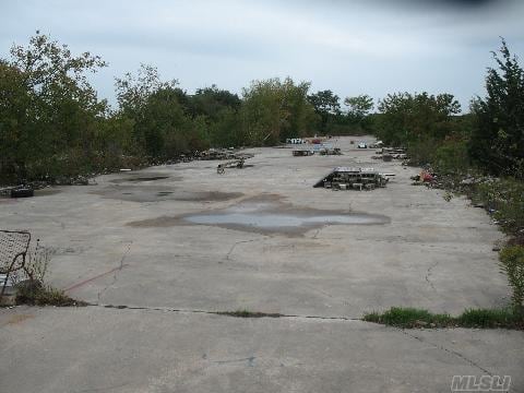
34 E Meadow Rd, Calverton, NY 11933

Save to a Folder
{{folder.Name}}
{{folder.ListingIds.length}} Properties
{{folder.ListingIds.length}} Property
Create a New Folder
Property Detail
34 E Meadow Rd
0600-080-00-01-00-002-003
THE MANORS AT B H SEC 2 LOT 34 OPEN SPACE
Agriculturalland
SUFFOLK
04
New York
B and X Area of moderate flood hazard, usually the area between the limits of the 100-year and 500-year floods.
2
2024
22.30 AC
2025
Eastern Suffolk
169705
Long Island (New York)
1,536 SF
Nassau County-Suffolk County, NY
NEARBY LISTINGS FOR SALE OR LEASE
DEMOGRAPHICS near 34 E Meadow Rd
1 mile
3 mile
5 mile
2025 Total Population
1,516
13,659
32,206
2030 Population
1,525
14,001
32,713
Pop Growth 2025-2030
+ 0.59%
+ 2.50%
+ 1.57%
Average Age
46
49
44
2025 Total Households
577
5,918
12,237
HH Growth 2025-2030
+ 0.52%
+ 2.31%
+ 1.45%
Median Household Inc
$114,999
$74,295
$82,120
Avg Household Size
2.60
2.20
2.50
2025 Avg HH Vehicles
2.00
2.00
2.00
Median Home Value
$568,493
$490,436
$474,021
Median Year Built
1991
1991
1984
Nearby Places
Map Layers
Map Styles
 Street
 Aerial
Layers
 Traffic
 Biking
Places
Listings with unknown addresses are not visible on the map
- Restaurants
- Banks
- Shops
- Fitness
- Groceries
PUBLIC TRANSPORTATION
COMMUTER RAIL
Riverhead Station (Greenport Branch - Long Island Rail Road)
Drive
Walk
Distance
Riverhead Station (Greenport Branch - Long Island Rail Road)
10 min
4.3 mi
AIRPORT
Long Island MacArthur
Drive
Walk
Distance
Long Island MacArthur
44 min
26.8 mi
Freight Ports
Port of New Haven
Drive
Walk
Distance
Port of New Haven
143 min
56.5 mi
SALE & LEASE HISTORY
LISTING DATE
SALE/LEASE

Feb 22, 2017
For Sale
Nearby Properties
Address
Land Use
TOTAL SIZE
Lot Size
Zoning
Address
Land Use
TOTAL SIZE
Lot Size
Zoning
450,000 SF
8.50 AC
3
Address
Land Use
TOTAL SIZE
Lot Size
Zoning
252,053 SF
31.60 AC
3
Address
Land Use
TOTAL SIZE
Lot Size
Zoning
42.70 AC
9
Address
Land Use
TOTAL SIZE
Lot Size
Zoning
47.30 AC
9
Address
Land Use
TOTAL SIZE
Lot Size
Zoning
127,334 SF
49.72 AC
04
Address
Land Use
TOTAL SIZE
Lot Size
Zoning
109.90 AC
Address
Land Use
TOTAL SIZE
Lot Size
Zoning
25,620 SF
7.03 AC
9
Address
Land Use
TOTAL SIZE
Lot Size
Zoning
9,715 SF
82.50 AC
9
Address
Land Use
TOTAL SIZE
Lot Size
Zoning
13.92 AC
04
Address
Land Use
TOTAL SIZE
Lot Size
Zoning
20.72 AC
09
Address
Land Use
TOTAL SIZE
Lot Size
Zoning
26.39 AC
04
Address
Land Use
TOTAL SIZE
Lot Size
Zoning
92.73 AC
Address
Land Use
TOTAL SIZE
Lot Size
Zoning
108,572 SF
17.30 AC
04
Address
Land Use
TOTAL SIZE
Lot Size
Zoning
13,773 SF
11.65 AC
03
Address
Land Use
TOTAL SIZE
Lot Size
Zoning
36.60 AC
RC
Address
Land Use
TOTAL SIZE
Lot Size
Zoning
1,435 SF
13.20 AC
Address
Land Use
TOTAL SIZE
Lot Size
Zoning
2,860 SF
9.38 AC
3
Address
Land Use
TOTAL SIZE
Lot Size
Zoning
15.40 AC
RA40
Address
Land Use
TOTAL SIZE
Lot Size
Zoning
1,190 SF
32.16 AC
09
Address
Land Use
TOTAL SIZE
Lot Size
Zoning
45.10 AC
Address
Land Use
TOTAL SIZE
Lot Size
Zoning
50.50 AC
04
Address
Land Use
TOTAL SIZE
Lot Size
Zoning
126,200 SF
14.09 AC
3
Address
Land Use
TOTAL SIZE
Lot Size
Zoning
70,775 SF
13 AC
4
Address
Land Use
TOTAL SIZE
Lot Size
Zoning
7.20 AC
RA40
Address
Land Use
TOTAL SIZE
Lot Size
Zoning
66,340 SF
6.81 AC
BC
Address
Land Use
TOTAL SIZE
Lot Size
Zoning
6,814 SF
349 AC
4
Address
Land Use
TOTAL SIZE
Lot Size
Zoning
55,614 SF
10.60 AC
03
Address
Land Use
TOTAL SIZE
Lot Size
Zoning
12.08 AC
DRC
Address
Land Use
TOTAL SIZE
Lot Size
Zoning
49,960 SF
5.08 AC
09
Address
Land Use
TOTAL SIZE
Lot Size
Zoning
131,859 SF
28.62 AC
09
The World's #1 Commercial Real Estate Marketplace
Connect with us
© 2026 CoStar Group
The information above has been obtained from sources believed reliable. While we do not doubt its accuracy we have not verified it and make no guarantee, warranty or representation about it. It is your responsibility to independently confirm its accuracy and completeness. Any projections, opinions, assumptions, or estimates used are for example only and do not represent the current or future performance of the property. The value of this transaction to you depends on tax and other factors which should be evaluated by your tax, financial, and legal advisors. You and your advisors should conduct a careful, independent investigation of the property to determine to your satisfaction the suitability of the property for your needs.