Property Record
34 Main St, Plaistow, NH 03865

Save to a Folder
{{folder.Name}}
{{folder.ListingIds.length}} Properties
{{folder.ListingIds.length}} Property
Create a New Folder
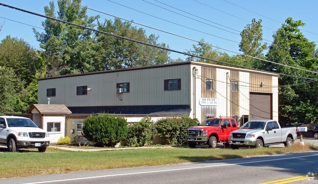
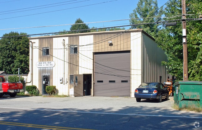
Property Detail
34 Main St
PLSW-000038-000038
ROCKINGHAM
Manufacturinglight
New Hampshire
C-2
000
B and X Area of moderate flood hazard, usually the area between the limits of the 100-year and 500-year floods.
0.47 AC
2025
Rockingham
2025
Boston
101101
Boston-Cambridge-Newton, MA-NH
5,880 SF
NEARBY LISTINGS FOR SALE OR LEASE
DEMOGRAPHICS near 34 Main St
1 mile
3 mile
5 mile
2025 Total Population
3,968
37,627
94,598
2030 Population
3,979
37,947
96,176
Pop Growth 2025-2030
+ 0.28%
+ 0.85%
+ 1.67%
Average Age
45
42
42
2025 Total Households
1,728
14,356
37,023
HH Growth 2025-2030
+ 0.12%
+ 0.77%
+ 1.63%
Median Household Inc
$105,779
$95,731
$93,685
Avg Household Size
2.30
2.50
2.50
2025 Avg HH Vehicles
2.00
2.00
2.00
Median Home Value
$436,111
$470,553
$479,143
Median Year Built
1976
1966
1971
Nearby Places
Map Layers
Map Styles
 Street
 Aerial
Layers
 Traffic
 Biking
Places
Listings with unknown addresses are not visible on the map
- Restaurants
- Banks
- Shops
- Fitness
- Groceries
PUBLIC TRANSPORTATION
COMMUTER RAIL
Haverhill (Haverhill Line - Massachusetts Bay Transportation Authority Commuter Rail (Purple Line))
Drive
Walk
Distance
Haverhill (Haverhill Line - Massachusetts Bay Transportation Authority Commuter Rail (Purple Line))
8 min
3.9 mi
Bradford (Haverhill Line - Massachusetts Bay Transportation Authority Commuter Rail (Purple Line))
Drive
Walk
Distance
Bradford (Haverhill Line - Massachusetts Bay Transportation Authority Commuter Rail (Purple Line))
9 min
4.4 mi
AIRPORT
Portsmouth International at Pease
Drive
Walk
Distance
Portsmouth International at Pease
43 min
31.2 mi
Manchester Boston Regional
Drive
Walk
Distance
Manchester Boston Regional
50 min
32.6 mi
General Edward Lawrence Logan International
Drive
Walk
Distance
General Edward Lawrence Logan International
54 min
39.7 mi
Nearby Properties
Address
Land Use
TOTAL SIZE
Lot Size
Zoning
Address
Land Use
TOTAL SIZE
Lot Size
Zoning
109.09 AC
Address
Land Use
TOTAL SIZE
Lot Size
Zoning
32.32 AC
Address
Land Use
TOTAL SIZE
Lot Size
Zoning
Address
Land Use
TOTAL SIZE
Lot Size
Zoning
195,120 SF
9.05 AC
Address
Land Use
TOTAL SIZE
Lot Size
Zoning
169,340 SF
14.95 AC
C-1
Address
Land Use
TOTAL SIZE
Lot Size
Zoning
257,286 SF
90 AC
LDR
Address
Land Use
TOTAL SIZE
Lot Size
Zoning
125,627 SF
46.02 AC
C-1
Address
Land Use
TOTAL SIZE
Lot Size
Zoning
72,019 SF
10.74 AC
Address
Land Use
TOTAL SIZE
Lot Size
Zoning
35,633 SF
19.15 AC
C-1
Address
Land Use
TOTAL SIZE
Lot Size
Zoning
2,400 SF
4 AC
MDR
Address
Land Use
TOTAL SIZE
Lot Size
Zoning
142,845 SF
20.99 AC
Address
Land Use
TOTAL SIZE
Lot Size
Zoning
102,488 SF
19.50 AC
Address
Land Use
TOTAL SIZE
Lot Size
Zoning
202,022 SF
13.29 AC
Address
Land Use
TOTAL SIZE
Lot Size
Zoning
126,618 SF
17.47 AC
Address
Land Use
TOTAL SIZE
Lot Size
Zoning
63,461 SF
7.61 AC
Address
Land Use
TOTAL SIZE
Lot Size
Zoning
74,723 SF
5.15 AC
Address
Land Use
TOTAL SIZE
Lot Size
Zoning
16.87 AC
Address
Land Use
TOTAL SIZE
Lot Size
Zoning
115,088 SF
27.42 AC
Address
Land Use
TOTAL SIZE
Lot Size
Zoning
2.09 AC
LDR
Address
Land Use
TOTAL SIZE
Lot Size
Zoning
51.41 AC
Address
Land Use
TOTAL SIZE
Lot Size
Zoning
99,441 SF
18.69 AC
C-1
Address
Land Use
TOTAL SIZE
Lot Size
Zoning
104,380 SF
20.08 AC
Address
Land Use
TOTAL SIZE
Lot Size
Zoning
106,921 SF
25.16 AC
Address
Land Use
TOTAL SIZE
Lot Size
Zoning
184,193 SF
24.80 AC
I
Address
Land Use
TOTAL SIZE
Lot Size
Zoning
32,074 SF
6.69 AC
C-1
Address
Land Use
TOTAL SIZE
Lot Size
Zoning
109,418 SF
17.06 AC
Address
Land Use
TOTAL SIZE
Lot Size
Zoning
67,705 SF
10.93 AC
TC- TO
Address
Land Use
TOTAL SIZE
Lot Size
Zoning
139,564 SF
10.71 AC
Address
Land Use
TOTAL SIZE
Lot Size
Zoning
3.89 AC
Address
Land Use
TOTAL SIZE
Lot Size
Zoning
55,960 SF
12.42 AC
I
The World's #1 Commercial Real Estate Marketplace
Connect with us
© 2026 CoStar Group
The information above has been obtained from sources believed reliable. While we do not doubt its accuracy we have not verified it and make no guarantee, warranty or representation about it. It is your responsibility to independently confirm its accuracy and completeness. Any projections, opinions, assumptions, or estimates used are for example only and do not represent the current or future performance of the property. The value of this transaction to you depends on tax and other factors which should be evaluated by your tax, financial, and legal advisors. You and your advisors should conduct a careful, independent investigation of the property to determine to your satisfaction the suitability of the property for your needs.