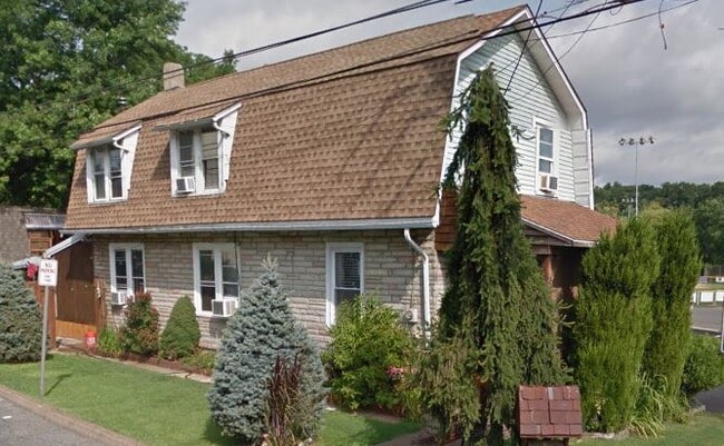
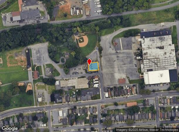
Property Record
40 N 21St North St, Easton, PA 18042
NEARBY LISTINGS FOR SALE OR LEASE
Property Detail
40 N 21St North St
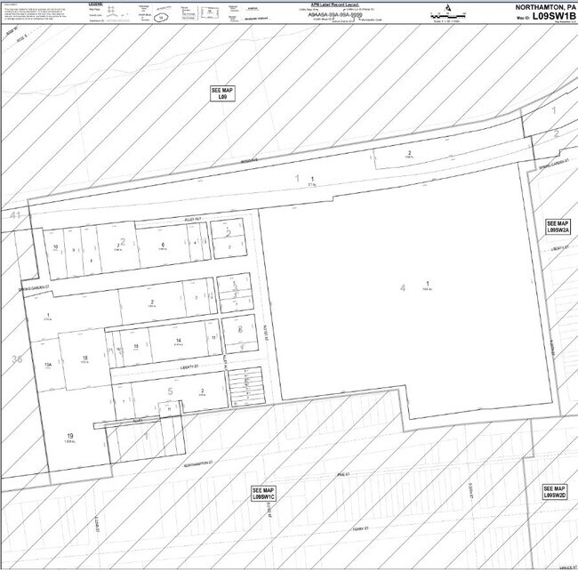
L9SW1B-3-8-0837
Plan Of Bissells Palmer Township
Officebuilding
Northampton
X
Pennsylvania
42095C0278E
0.18 AC
2025
Lehigh Valley
2025
Philadelphia
014600
Allentown-Bethlehem-Easton, PA-NJ
6,384 SF
DEMOGRAPHICS near 40 N 21St North St
1 Mile
3 Mile
5 Mile
2024 Total Population
15,802
87,734
139,925
2029 Population
15,766
88,451
141,504
Pop Growth 2024-2029
(0.23%)
+ 0.82%
+ 1.13%
Average Age
38
40
41
2024 Total Households
5,905
32,762
53,011
HH Growth 2024-2029
(0.20%)
+ 0.84%
+ 1.19%
Median Household Inc
$73,696
$79,032
$83,235
Avg Household Size
2.50
2.50
2.50
2024 Avg HH Vehicles
2.00
2.00
2.00
Median Home Value
$179,462
$240,023
$259,962
Median Year Built
1948
1959
1968
Nearby Places
- Restaurants
- Banks
- Shops
- Fitness
- Groceries
PUBLIC TRANSPORTATION
AIRPORT
Lehigh Valley International
DRIVE
WALK
Distance
Lehigh Valley International
20 min
12.5 mi
Nearby Properties
Address
Land Use
TOTAL SIZE
Lot Size
Zoning
Address
Land Use
TOTAL SIZE
Lot Size
Zoning
87,508 SF
40.79 AC
CCE
Address
Land Use
TOTAL SIZE
Lot Size
Zoning
13,916 SF
9.47 AC
RLD
Address
Land Use
TOTAL SIZE
Lot Size
Zoning
17.06 AC
R-75
Address
Land Use
TOTAL SIZE
Lot Size
Zoning
127,731 SF
56.29 AC
R12
Address
Land Use
TOTAL SIZE
Lot Size
Zoning
205,594 SF
61.99 AC
C
Address
Land Use
TOTAL SIZE
Lot Size
Zoning
6,966 SF
8.86 AC
RMD
Address
Land Use
TOTAL SIZE
Lot Size
Zoning
84,805 SF
12.20 AC
CHDD
Address
Land Use
TOTAL SIZE
Lot Size
Zoning
358,875 SF
39.99 AC
PO/IP
Address
Land Use
TOTAL SIZE
Lot Size
Zoning
4,913 SF
27.03 AC
PIC
Address
Land Use
TOTAL SIZE
Lot Size
Zoning
162,960 SF
16.26 AC
HDR
Address
Land Use
TOTAL SIZE
Lot Size
Zoning
176,397 SF
45.38 AC
HI
Address
Land Use
TOTAL SIZE
Lot Size
Zoning
26,714 SF
33.71 AC
RI
Address
Land Use
TOTAL SIZE
Lot Size
Zoning
430,201 SF
17.30 AC
I
Address
Land Use
TOTAL SIZE
Lot Size
Zoning
281,400 SF
19.80 AC
PO/IP
Address
Land Use
TOTAL SIZE
Lot Size
Zoning
94,794 SF
17.51 AC
GB
Address
Land Use
TOTAL SIZE
Lot Size
Zoning
111,271 SF
15.32 AC
C
Address
Land Use
TOTAL SIZE
Lot Size
Zoning
14.03 AC
I-2
Address
Land Use
TOTAL SIZE
Lot Size
Zoning
254,848 SF
19.50 AC
PO/IP
Address
Land Use
TOTAL SIZE
Lot Size
Zoning
65.90 AC
PO/IP
Address
Land Use
TOTAL SIZE
Lot Size
Zoning
135,293 SF
38 AC
C
Address
Land Use
TOTAL SIZE
Lot Size
Zoning
21.80 AC
I-1
Address
Land Use
TOTAL SIZE
Lot Size
Zoning
107,028 SF
3.31 AC
R2
Address
Land Use
TOTAL SIZE
Lot Size
Zoning
6.35 AC
R-75
Address
Land Use
TOTAL SIZE
Lot Size
Zoning
319,578 SF
27.91 AC
I
Address
Land Use
TOTAL SIZE
Lot Size
Zoning
97,066 SF
14.02 AC
MDB
Address
Land Use
TOTAL SIZE
Lot Size
Zoning
11.73 AC
I-1
Address
Land Use
TOTAL SIZE
Lot Size
Zoning
59,583 SF
3.87 AC
C
Address
Land Use
TOTAL SIZE
Lot Size
Zoning
2 AC
B-4
Address
Land Use
TOTAL SIZE
Lot Size
Zoning
35,575 SF
35.21 AC
C
Address
Land Use
TOTAL SIZE
Lot Size
Zoning
182,000 SF
12.55 AC
PO/IP
The World's #1 Commercial Real Estate Marketplace
Connect with us
© 2025 CoStar Group
The information above has been obtained from sources believed reliable. While we do not doubt its accuracy we have not verified it and make no guarantee, warranty or representation about it. It is your responsibility to independently confirm its accuracy and completeness. Any projections, opinions, assumptions, or estimates used are for example only and do not represent the current or future performance of the property. The value of this transaction to you depends on tax and other factors which should be evaluated by your tax, financial, and legal advisors. You and your advisors should conduct a careful, independent investigation of the property to determine to your satisfaction the suitability of the property for your needs.