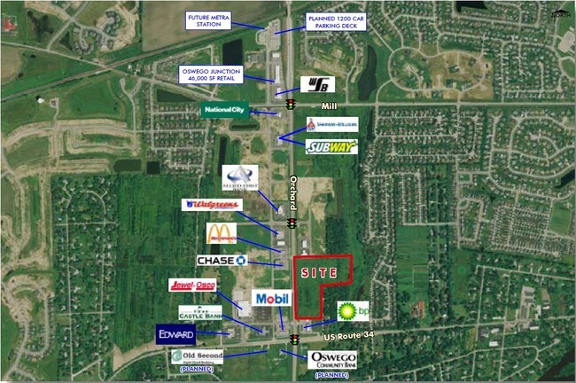
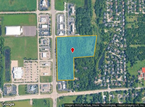
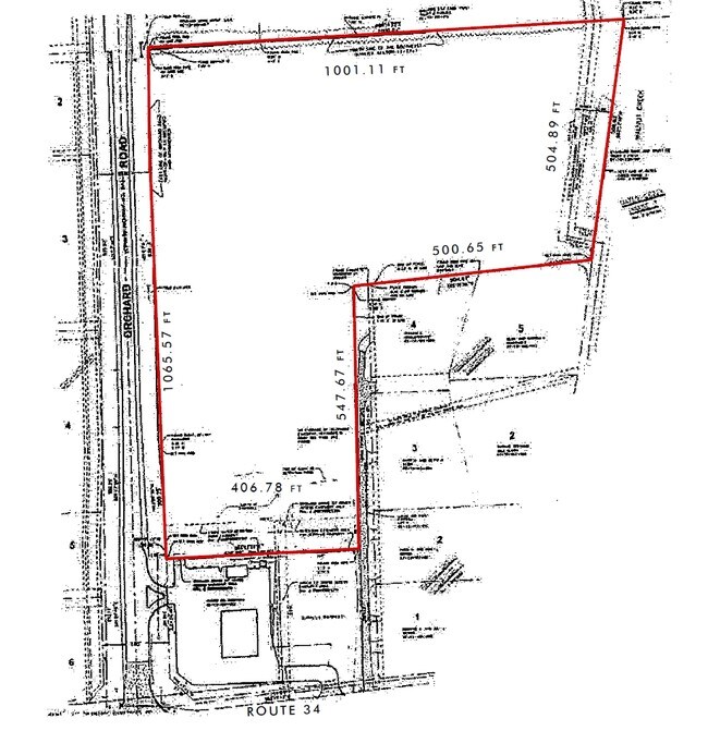
Property Record
34 Orchard Ave, Oswego, IL 60543
NEARBY LISTINGS FOR SALE OR LEASE
Property Detail
34 Orchard Ave
Chicago-Naperville-Elgin, IL-IN-WI
Walnut Creek Sub
02-13-401-004
SEC 13-37-7 16.67 AC TR LYG WLY WALNUT CREEK SUB AND ELY ORCHARD ROAD, VILLAGE OF OSWEGO
Commercialacreage
Kendall
X
Illinois
17093C0045H
2
2024
16.55 AC
2024
Western East/West Corr
890302
Chicago
DEMOGRAPHICS near 34 Orchard Ave
1 Mile
3 Mile
5 Mile
2024 Total Population
6,110
51,539
101,309
2029 Population
6,708
56,748
109,845
Pop Growth 2024-2029
+ 9.79%
+ 10.11%
+ 8.43%
Average Age
37
37
37
2024 Total Households
2,008
16,947
33,810
HH Growth 2024-2029
+ 9.86%
+ 10.18%
+ 8.50%
Median Household Inc
$105,641
$99,630
$92,349
Avg Household Size
3.00
3.00
2.90
2024 Avg HH Vehicles
2.00
2.00
2.00
Median Home Value
$292,792
$267,255
$256,712
Median Year Built
2002
2001
1999
Nearby Places
Map Layers
Map Styles
 Street
 Aerial
- Restaurants
- Banks
- Shops
- Fitness
- Groceries
PUBLIC TRANSPORTATION
COMMUTER RAIL
Aurora Station (Burlington Northern-Santa Fe Railway Line - Northeast Illinois Regional Commuter Railroad (Metra))
DRIVE
WALK
Distance
Aurora Station (Burlington Northern-Santa Fe Railway Line - Northeast Illinois Regional Commuter Railroad (Metra))
14 min
7.9 mi
Plano Amtrak Station (Carl Sandburg - Amtrak, Illinois Zephyr - Amtrak)
DRIVE
WALK
Distance
Plano Amtrak Station (Carl Sandburg - Amtrak, Illinois Zephyr - Amtrak)
17 min
9.2 mi
Freight Ports
Port Milwaukee
DRIVE
WALK
Distance
Port Milwaukee
147 min
117.8 mi
SALE & LEASE HISTORY
LISTING DATE
SALE/LEASE

May 19, 2021
For Sale
Nearby Properties
Address
Land Use
TOTAL SIZE
Lot Size
Zoning
Address
Land Use
TOTAL SIZE
Lot Size
Zoning
350.78 AC
Address
Land Use
TOTAL SIZE
Lot Size
Zoning
56.02 AC
Address
Land Use
TOTAL SIZE
Lot Size
Zoning
218,020 SF
21.35 AC
Address
Land Use
TOTAL SIZE
Lot Size
Zoning
97,136 SF
6.08 AC
Address
Land Use
TOTAL SIZE
Lot Size
Zoning
9.86 AC
Address
Land Use
TOTAL SIZE
Lot Size
Zoning
118,236 SF
20.93 AC
Address
Land Use
TOTAL SIZE
Lot Size
Zoning
56.13 AC
Address
Land Use
TOTAL SIZE
Lot Size
Zoning
581,048 SF
37.29 AC
Address
Land Use
TOTAL SIZE
Lot Size
Zoning
287,902 SF
3.31 AC
Address
Land Use
TOTAL SIZE
Lot Size
Zoning
49,292 SF
1.70 AC
Address
Land Use
TOTAL SIZE
Lot Size
Zoning
49,292 SF
1.70 AC
Address
Land Use
TOTAL SIZE
Lot Size
Zoning
49,292 SF
1.70 AC
Address
Land Use
TOTAL SIZE
Lot Size
Zoning
84,884 SF
5.23 AC
Address
Land Use
TOTAL SIZE
Lot Size
Zoning
62,164 SF
6.76 AC
Address
Land Use
TOTAL SIZE
Lot Size
Zoning
39,020 SF
1.70 AC
Address
Land Use
TOTAL SIZE
Lot Size
Zoning
31.35 AC
Address
Land Use
TOTAL SIZE
Lot Size
Zoning
33,730 SF
6.95 AC
Address
Land Use
TOTAL SIZE
Lot Size
Zoning
3,096 SF
15.44 AC
Address
Land Use
TOTAL SIZE
Lot Size
Zoning
120,058 SF
10.71 AC
Address
Land Use
TOTAL SIZE
Lot Size
Zoning
18,774 SF
4.95 AC
Address
Land Use
TOTAL SIZE
Lot Size
Zoning
178,010 SF
9 AC
Address
Land Use
TOTAL SIZE
Lot Size
Zoning
36,711 SF
0.44 AC
Address
Land Use
TOTAL SIZE
Lot Size
Zoning
16,152 SF
2.40 AC
Address
Land Use
TOTAL SIZE
Lot Size
Zoning
18,896 SF
2.49 AC
Address
Land Use
TOTAL SIZE
Lot Size
Zoning
65,646 SF
2.76 AC
Address
Land Use
TOTAL SIZE
Lot Size
Zoning
4,632 SF
3.24 AC
Address
Land Use
TOTAL SIZE
Lot Size
Zoning
8,056 SF
2.64 AC
Address
Land Use
TOTAL SIZE
Lot Size
Zoning
86,764 SF
5.38 AC
Address
Land Use
TOTAL SIZE
Lot Size
Zoning
10,046 SF
1.40 AC
Address
Land Use
TOTAL SIZE
Lot Size
Zoning
9,945 SF
1.25 AC
The World's #1 Commercial Real Estate Marketplace
Connect with us
© 2025 CoStar Group
The information above has been obtained from sources believed reliable. While we do not doubt its accuracy we have not verified it and make no guarantee, warranty or representation about it. It is your responsibility to independently confirm its accuracy and completeness. Any projections, opinions, assumptions, or estimates used are for example only and do not represent the current or future performance of the property. The value of this transaction to you depends on tax and other factors which should be evaluated by your tax, financial, and legal advisors. You and your advisors should conduct a careful, independent investigation of the property to determine to your satisfaction the suitability of the property for your needs.